


$1,200
/ Month
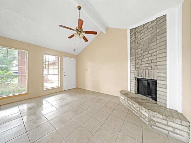
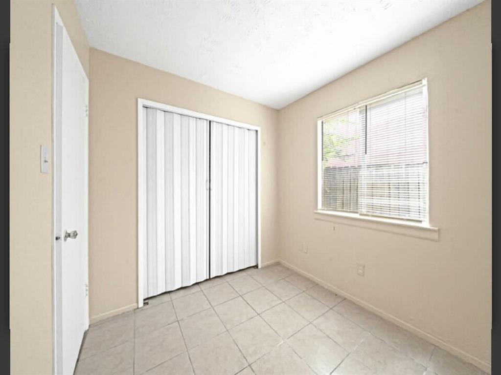
10166 Inwood Hollow Ln
Houston, TX 77088
2 Weeks Ago
|
Edit
Favorites
10166 Inwood Hollow Ln

Favorites
Check Back Soon for Upcoming Availability
| Beds | Baths | Average SF |
|---|---|---|
| 2 Bedrooms 2 Bedrooms 2 Br | 1 Bath 1 Bath 1 Ba | — |
Fees and Policies
Details
Lease Options
-
12 Months
About This Property
Greater Inwood is a charming suburban neighborhood located about 13 miles northwest of Downtown Houston. Multiple shopping centers and plazas are strewn throughout the neighborhood, allowing residents quick access to an array of diverse restaurants, markets, and convenience stores. The White Oak Bayou Greenway Trail cuts directly through the community, providing great opportunities for outdoor recreation close to home. Nearby Interstate 45 and U.S. Route 290 connect Greater Inwood to Downtown Houston within minutes.
10166 Inwood Hollow Ln is a house located in Harris County and the 77088 ZIP Code. This area is served by the Klein Independent attendance zone.
House Features
- Smoke Free
Location
Get Directions
Greater Inwood is a charming suburban neighborhood located about 13 miles northwest of Downtown Houston. Residents are drawn to Greater Inwood for its peaceful atmosphere, affordable cost of living, and convenient locale. Greater Inwood offers a broad range of apartments and houses available for rent along attractive, tree-lined streets.
Multiple shopping centers and plazas are strewn throughout the neighborhood, affording residents quick access to an array of diverse restaurants, markets, and convenience stores. The White Oak Bayou Greenway Trail cuts directly through the community, providing great opportunities for outdoor recreation close to home. Nearby Interstate 45 and U.S. Route 290 connect Greater Inwood to Downtown Houston within minutes.
Learn more about living in Greater InwoodBelow are rent ranges for similar nearby apartments
Amenities
- Smoke Free
Education
| Colleges & Universities | Distance | ||
|---|---|---|---|
| Colleges & Universities | Distance | ||
| Drive: | 19 min | 13.2 mi | |
| Drive: | 23 min | 15.2 mi | |
| Drive: | 25 min | 16.7 mi | |
| Drive: | 26 min | 17.5 mi |
10166 Inwood Hollow Ln is within 19 minutes or 13.2 miles from The Art Institute of Houston. It is also near Univ. of Houston, Downtown and University of St Thomas.
Schools


Public Elementary School
Grades PK-5
618 Students
Nearby
Public Elementary School
Grades PK-5
521 Students
Attendance Zone
Public Middle School
Grades 6-8
1,062 Students
Attendance Zone
Public High School
Grades 9-12
3,481 Students
Attendance Zone
Private Elementary, Middle & High School
Grades K-10
Nearby
Private Elementary & Middle School
Grades K-8
56 Students
Nearby
Private Elementary School
Grades PK-1
Nearby
Private High School
Grades 9-12
Nearby
School data provided by
 The GreatSchools Rating helps parents compare schools within a state based on a variety of school quality indicators and provides a helpful picture of how effectively each school serves all of its students. Ratings are on a scale of 1 (below average) to 10 (above average) and can include test scores, college readiness, academic progress, advanced courses, equity, discipline and attendance data. We also advise parents to visit schools, consider other information on school performance and programs, and consider family needs as part of the school selection process.
View GreatSchools Rating Methodology
Data provided by GreatSchools.org © 2025. All rights reserved.
View GreatSchools Rating Methodology
Data provided by GreatSchools.org © 2025. All rights reserved.
Transportation options available in Houston include Northline Transit Center / Hcc, located 10.1 miles from 10166 Inwood Hollow Ln. 10166 Inwood Hollow Ln is near George Bush Intcntl/Houston, located 16.6 miles or 22 minutes away, and William P Hobby, located 28.2 miles or 44 minutes away.
| Transit / Subway | Distance | ||
|---|---|---|---|
| Transit / Subway | Distance | ||
|
|
Drive: | 18 min | 10.1 mi |
|
|
Drive: | 19 min | 11.7 mi |
|
|
Drive: | 19 min | 12.5 mi |
|
|
Drive: | 19 min | 13.0 mi |
| Commuter Rail | Distance | ||
|---|---|---|---|
| Commuter Rail | Distance | ||
|
|
Drive: | 24 min | 15.4 mi |
| Airports | Distance | ||
|---|---|---|---|
| Airports | Distance | ||
|
George Bush Intcntl/Houston
|
Drive: | 22 min | 16.6 mi |
|
William P Hobby
|
Drive: | 44 min | 28.2 mi |
Time and distance from 10166 Inwood Hollow Ln.
| Shopping Centers | Distance | ||
|---|---|---|---|
| Shopping Centers | Distance | ||
| Walk: | 13 min | 0.7 mi | |
| Walk: | 15 min | 0.8 mi | |
| Walk: | 17 min | 0.9 mi |
10166 Inwood Hollow Ln has 3 shopping centers within 0.9 mile, which is about a 17-minute walk. The miles and minutes will be for the farthest away property.
| Parks and Recreation | Distance | ||
|---|---|---|---|
| Parks and Recreation | Distance | ||
|
Cy-Champ Park
|
Drive: | 13 min | 7.7 mi |
|
Kickerillo-Mischer Preserve
|
Drive: | 12 min | 8.9 mi |
|
Hundred Acre Wood Preserve
|
Drive: | 14 min | 9.5 mi |
|
Fallen Warriors Memorial
|
Drive: | 14 min | 9.7 mi |
|
Bear Creek Pioneers Park
|
Drive: | 22 min | 12.6 mi |
10166 Inwood Hollow Ln has 5 parks within 12.6 miles, including Cy-Champ Park, Fallen Warriors Memorial, and Kickerillo-Mischer Preserve.
| Hospitals | Distance | ||
|---|---|---|---|
| Hospitals | Distance | ||
| Drive: | 10 min | 6.8 mi | |
| Drive: | 13 min | 7.4 mi | |
| Drive: | 13 min | 8.0 mi |
10166 Inwood Hollow Ln has 3 hospitals within 8.0 miles, the nearest is Houston Methodist Willowbrook Hospital which is 6.8 miles away and a 10 minute drive.
| Military Bases | Distance | ||
|---|---|---|---|
| Military Bases | Distance | ||
| Drive: | 57 min | 41.7 mi | |
| Drive: | 86 min | 67.2 mi |
10166 Inwood Hollow Ln is 41.7 miles from Lyndon B Johnson Space Center, and is convenient to other military bases, including Pelican Spit Military Reservation.
You May Also Like
Similar Rentals Nearby


What Are Walk Score®, Transit Score®, and Bike Score® Ratings?
Walk Score® measures the walkability of any address. Transit Score® measures access to public transit. Bike Score® measures the bikeability of any address.
What is a Sound Score Rating?
A Sound Score Rating aggregates noise caused by vehicle traffic, airplane traffic and local sources
10166 Inwood Hollow Ln
Houston, TX 77088