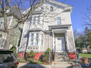
$4,400 / Month
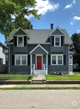
1040 S Main St
Bellingham, MA 02019
2 Weeks Ago
Favorites
1040 S Main St

Favorites
Check Back Soon for Upcoming Availability
| Beds | Baths | Average SF |
|---|---|---|
| 4 Bedrooms 4 Bedrooms 4 Br | 2 Baths 2 Baths 2 Ba | — |
About This Property
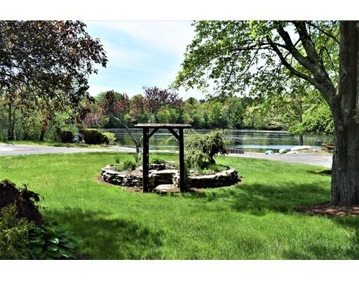
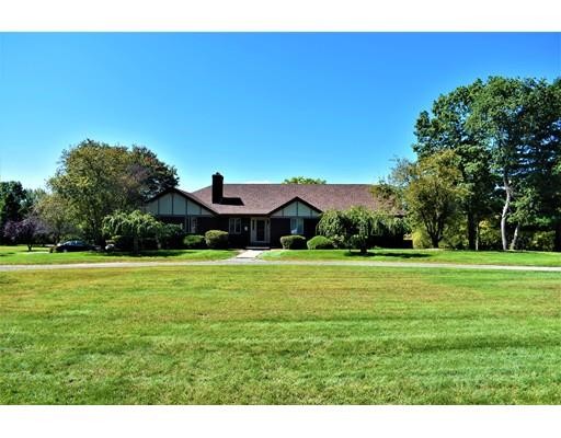
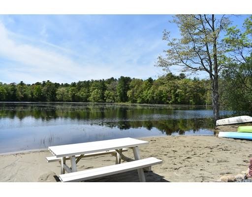
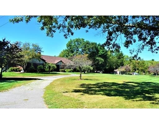
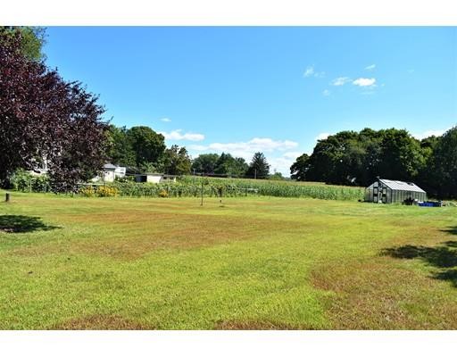
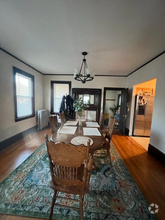
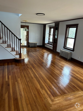
Beautiful property with endless possibilities. Includes 4 bedrooms with bonus room. Large dining area with hard wood flooring overlooking 7 acre pond perfect for entertaining. Sun room or office also overlooks pond & beach. Main bathroom includes tub & shower stall. Welcoming entry way with basement access, also hardwood along with main hallway. Inviting kitchen, island, radiant heat flooring & view of stone gazebo. Furniture, window treatments negotiable. Large living room with gorgeous pine cathedral ceilings. Floor to ceiling stone working fireplace. Solar Panels on 3 year old roof. Property offers mixed use, residential, in home business or commercial business use. Circular driveway with multiple parking spots, use of meadow & fenced area with barn structure possibly for 1 to 2 horses. Access to 7 acre pond, sandy beach, equestrian trails, kayaking, swimming and peaceful sunsets with beautiful views. Kennel structure use, green house, grape vines all negotiable.
1040 S Main St is a house located in Norfolk County and the 02019 ZIP Code. This area is served by the Bellingham attendance zone.
House Features
Air Conditioning
Dishwasher
Refrigerator
Fireplace
- Air Conditioning
- Fireplace
- Dishwasher
- Oven
- Range
- Refrigerator
- Walking/Biking Trails
- Patio
- Porch
- Garden
- Greenhouse
Fees and Policies
The fees below are based on community-supplied data and may exclude additional fees and utilities.
- Dogs Allowed
-
Fees not specified
- Cats Allowed
-
Fees not specified
Details
Utilities Included
-
Water
Location
Get Directions
495-South is a large area surrounding Interstate 495 about 20 miles south of Boston. This suburban town features peaceful neighborhoods nestled in forested areas paired with commercial developments. Renters have the choice of moderately priced to luxury apartments, condos, and single-family homes. An abundance of shopping and dining choices are scattered along the town’s major thoroughfares. Ponds, creeks, and large natural areas like Franklin State Forest and DelCarte Conservation Area provide relaxing outdoor activities. Residents have access to big-city amenities by driving a bit north into Boston, and the eclectic downtown districts of Worcester and Framingham are situated outside of the western and eastern corners of town.
Learn more about living in 495-SouthBelow are rent ranges for similar nearby apartments
Amenities
- Air Conditioning
- Fireplace
- Dishwasher
- Oven
- Range
- Refrigerator
- Patio
- Porch
- Garden
- Greenhouse
- Walking/Biking Trails
Expenses
Utilities Included
Water
Included
Education
| Colleges & Universities | Distance | ||
|---|---|---|---|
| Colleges & Universities | Distance | ||
| Drive: | 23 min | 13.6 mi | |
| Drive: | 22 min | 14.2 mi | |
| Drive: | 26 min | 18.4 mi | |
| Drive: | 28 min | 19.0 mi |
1040 S Main St is within 22 minutes or 14.2 miles from Bryant University. It is also near C.C. of Rhode Island, Flanagan and Providence College.
Schools


Public Elementary School
Grades PK-2
425 Students
Nearby
Public Elementary & Middle School
Grades 4-7
587 Students
Nearby
Public Elementary School
Grades K-3
300 Students
Attendance Zone
Public Middle & High School
Grades 8-12
747 Students
Attendance Zone
Public Middle & High School
Grades 7-12
28 Students
Attendance Zone
Public High School
Grades 9-12
957 Students
Nearby
Private Elementary, Middle & High School
Grades PK-12
192 Students
Nearby
Private Elementary, Middle & High School
Grades 1-10
Nearby
School data provided by
 The GreatSchools Rating helps parents compare schools within a state based on a variety of school quality indicators and provides a helpful picture of how effectively each school serves all of its students. Ratings are on a scale of 1 (below average) to 10 (above average) and can include test scores, college readiness, academic progress, advanced courses, equity, discipline and attendance data. We also advise parents to visit schools, consider other information on school performance and programs, and consider family needs as part of the school selection process.
View GreatSchools Rating Methodology
View GreatSchools Rating Methodology
Transportation options available in Bellingham include Newton Highlands Station, located 25.8 miles from 1040 S Main St. 1040 S Main St is near Rhode Island Tf Green International, located 27.2 miles or 41 minutes away, and Worcester Regional, located 37.1 miles or 53 minutes away.
| Transit / Subway | Distance | ||
|---|---|---|---|
| Transit / Subway | Distance | ||
|
|
Drive: | 51 min | 25.8 mi |
|
|
Drive: | 51 min | 26.0 mi |
|
|
Drive: | 47 min | 35.4 mi |
|
|
Drive: | 48 min | 35.7 mi |
|
|
Drive: | 49 min | 36.4 mi |
| Commuter Rail | Distance | ||
|---|---|---|---|
| Commuter Rail | Distance | ||
|
|
Drive: | 8 min | 3.6 mi |
|
|
Drive: | 11 min | 5.4 mi |
|
|
Drive: | 19 min | 9.9 mi |
|
|
Drive: | 27 min | 14.1 mi |
|
|
Drive: | 25 min | 16.8 mi |
| Airports | Distance | ||
|---|---|---|---|
| Airports | Distance | ||
|
Rhode Island Tf Green International
|
Drive: | 41 min | 27.2 mi |
|
Worcester Regional
|
Drive: | 53 min | 37.1 mi |
Time and distance from 1040 S Main St.
| Shopping Centers | Distance | ||
|---|---|---|---|
| Shopping Centers | Distance | ||
| Drive: | 3 min | 1.4 mi | |
| Drive: | 2 min | 1.6 mi | |
| Drive: | 3 min | 1.8 mi |
1040 S Main St has 3 shopping centers within 1.8 miles, which is about a 3-minute drive. The miles and minutes will be for the farthest away property.
| Parks and Recreation | Distance | ||
|---|---|---|---|
| Parks and Recreation | Distance | ||
|
World War II Memorial State Park
|
Drive: | 8 min | 4.9 mi |
|
Blackstone River Valley National Heritage Corridor
|
Drive: | 8 min | 5.4 mi |
|
Fort Nature Refuge
|
Drive: | 16 min | 9.7 mi |
|
Blackstone River and Canal Heritage State Park
|
Drive: | 19 min | 10.2 mi |
|
Mass Audubon's Stony Brook Wildlife Sanctuary
|
Drive: | 21 min | 10.8 mi |
1040 S Main St has 5 parks within 10.8 miles, including World War II Memorial State Park, Blackstone River Valley National Heritage Corridor, and Fort Nature Refuge.
| Hospitals | Distance | ||
|---|---|---|---|
| Hospitals | Distance | ||
| Drive: | 8 min | 5.2 mi | |
| Drive: | 10 min | 6.4 mi |
1040 S Main St is 5.2 miles from Landmark Medical Center, and is convenient to other hospitals, including Milford Regional Medical Center.
| Military Bases | Distance | ||
|---|---|---|---|
| Military Bases | Distance | ||
| Drive: | 39 min | 18.9 mi |
1040 S Main St is 18.9 miles and a 39 minute drive from US Military Reservation.
You May Also Like
Similar Rentals Nearby
What Are Walk Score®, Transit Score®, and Bike Score® Ratings?
Walk Score® measures the walkability of any address. Transit Score® measures access to public transit. Bike Score® measures the bikeability of any address.
What is a Sound Score Rating?
A Sound Score Rating aggregates noise caused by vehicle traffic, airplane traffic and local sources

1040 S Main St
Bellingham, MA 02019