$3,450 / Month
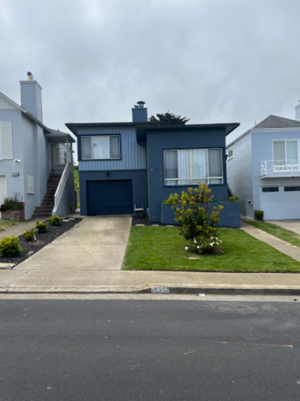
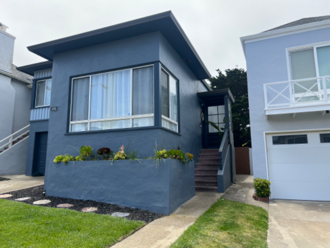
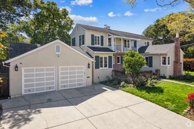
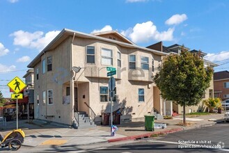
1066 S Mayfair Ave
Daly City, CA 94015
2 Weeks Ago
Favorites
1066 S Mayfair Ave

Favorites
Check Back Soon for Upcoming Availability
| Beds | Baths | Average SF |
|---|---|---|
| 2 Bedrooms 2 Bedrooms 2 Br | 1 Bath 1 Bath 1 Ba | 940 SF |
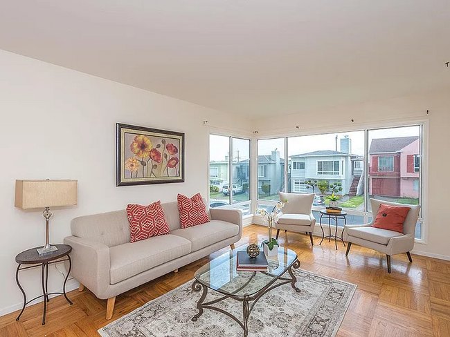
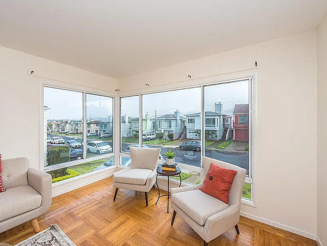
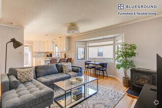
About This Property
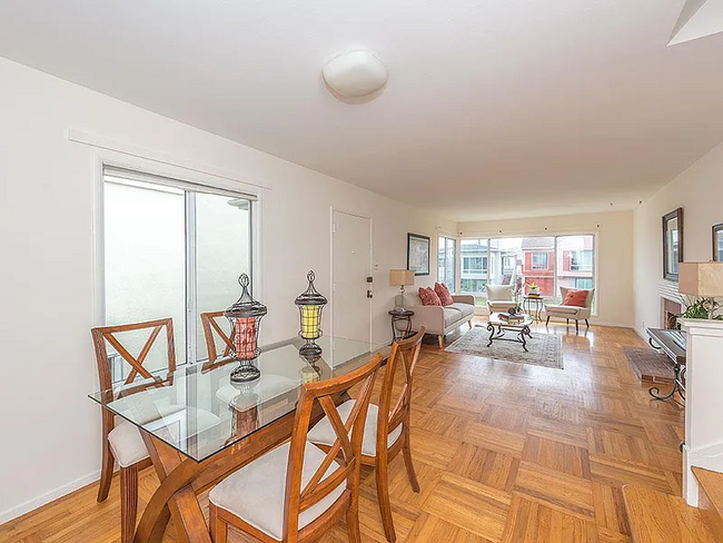
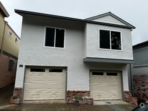
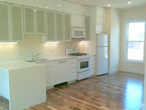
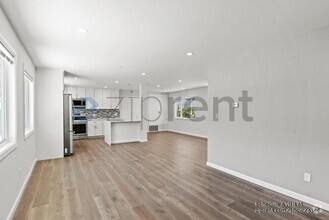
Property Id: 1207145 Beautiful home recently renovated and ready to move-in with 2 bedrooms and one bath and large backyard and large garage. Located in a quiet neighborhood within walking distance to Westlake Shopping (great restaurants and grocery stores) & less than 2 miles from San Francisco and conveniently located with easy access to major highways CA-1, CA-280, SamTrans, Muni and BART, making the commute to SF, East Bay & Silicon Valley very easy. The home is blocks away from great schools and local parks. Some of the best features are the parking availability with 1 car garage and 2 driveway spaces and a newly landscaped front yard with a huge backyard that is regularly maintained by a professional landscaper. Lease Terms and Requirements: Minimum of 700 score or higher, income required 3X monthly rent. No prior convictions, no felonies, no bankruptcies. Move in funds: 1st and last month's rent and $4,000 security deposit. Pre-screening questions required for viewing.
1066 S Mayfair Ave is a house located in San Mateo County and the 94015 ZIP Code. This area is served by the Jefferson Elementary attendance zone.
House Features
Washer/Dryer
Hardwood Floors
Refrigerator
Security System
- Washer/Dryer
- Cable Ready
- Security System
- Oven
- Refrigerator
- Hardwood Floors
- Vinyl Flooring
- Bicycle Storage
- Fenced Lot
- Lawn
Fees and Policies
The fees below are based on community-supplied data and may exclude additional fees and utilities.
- Parking
-
Garage--
Property Address:
1066 S Mayfair Ave,
Daly City,
CA
94015
Located about nine miles southwest of San Francisco, Westlake is a picturesque Daly City neighborhood nestled alongside the Pacific Ocean. Westlake is renowned for its distinctive architecture, serving as an early example of a master-planned community after World War II.
Today, Westlake is revered for its exceptional schools and stunning oceanside vistas. The neighborhood’s steep hills afford many of Westlake’s rentals beautiful views. Residents enjoy their gorgeous surroundings at the local Mussel Rock Park and Thornton State Beach, as well as the nearby Fort Funston, Lake Merced Park, and Pacifica State Beach.
Although the neighborhood is mostly residential, there are plenty of great shopping and dining options at Westlake Shopping Center in the northeastern portion of the community. Commuting from Westlake is simple with convenience to Interstate 280 and the Daly City BART Station.
Learn more about living in WestlakeBelow are rent ranges for similar nearby apartments
Amenities
- Washer/Dryer
- Cable Ready
- Security System
- Oven
- Refrigerator
- Hardwood Floors
- Vinyl Flooring
- Fenced Lot
- Lawn
- Bicycle Storage
Education
| Colleges & Universities | Distance | ||
|---|---|---|---|
| Colleges & Universities | Distance | ||
| Drive: | 9 min | 3.8 mi | |
| Drive: | 9 min | 4.6 mi | |
| Drive: | 11 min | 5.8 mi | |
| Drive: | 15 min | 6.8 mi |
1066 S Mayfair Ave is within 9 minutes or 3.8 miles from San Francisco State University. It is also near City College of San Francisco and Skyline College.
Schools


Public Elementary School
Grades K-5
394 Students
Nearby
Public Elementary School
Grades K-5
315 Students
Attendance Zone
Public Middle School
Grades 6-8
500 Students
Attendance Zone
Public High School
Grades 9-12
1,159 Students
Attendance Zone
Public High School
Grades 9-12
1,302 Students
Attendance Zone
Private Elementary & Middle School
Grades PK-8
131 Students
Nearby
Private Elementary & Middle School
Grades K-8
454 Students
Nearby
School data provided by
 The GreatSchools Rating helps parents compare schools within a state based on a variety of school quality indicators and provides a helpful picture of how effectively each school serves all of its students. Ratings are on a scale of 1 (below average) to 10 (above average) and can include test scores, college readiness, academic progress, advanced courses, equity, discipline and attendance data. We also advise parents to visit schools, consider other information on school performance and programs, and consider family needs as part of the school selection process.
View GreatSchools Rating Methodology
View GreatSchools Rating Methodology
Transportation options available in Daly City include Colma Station, located 2.2 miles from 1066 S Mayfair Ave. 1066 S Mayfair Ave is near San Francisco International, located 11.2 miles or 18 minutes away, and Metro Oakland International, located 29.2 miles or 42 minutes away.
| Transit / Subway | Distance | ||
|---|---|---|---|
| Transit / Subway | Distance | ||
|
|
Drive: | 6 min | 2.2 mi |
|
|
Drive: | 6 min | 2.6 mi |
|
|
Drive: | 6 min | 3.1 mi |
|
|
Drive: | 6 min | 3.2 mi |
|
|
Drive: | 7 min | 3.4 mi |
| Commuter Rail | Distance | ||
|---|---|---|---|
| Commuter Rail | Distance | ||
| Drive: | 15 min | 7.8 mi | |
| Drive: | 13 min | 8.6 mi | |
| Drive: | 13 min | 8.6 mi | |
| Drive: | 13 min | 9.6 mi | |
| Drive: | 15 min | 10.5 mi |
| Airports | Distance | ||
|---|---|---|---|
| Airports | Distance | ||
|
San Francisco International
|
Drive: | 18 min | 11.2 mi |
|
Metro Oakland International
|
Drive: | 42 min | 29.2 mi |
Time and distance from 1066 S Mayfair Ave.
| Shopping Centers | Distance | ||
|---|---|---|---|
| Shopping Centers | Distance | ||
| Walk: | 17 min | 0.9 mi | |
| Walk: | 18 min | 0.9 mi | |
| Drive: | 4 min | 1.5 mi |
1066 S Mayfair Ave has 3 shopping centers within 1.5 miles, which is about a 4-minute walk. The miles and minutes will be for the farthest away property.
| Parks and Recreation | Distance | ||
|---|---|---|---|
| Parks and Recreation | Distance | ||
|
San Francisco State Univ. Observatory
|
Drive: | 9 min | 3.6 mi |
|
Charles F. Hagar Planetarium
|
Drive: | 9 min | 3.6 mi |
|
San Francisco Zoo
|
Drive: | 7 min | 3.6 mi |
|
San Bruno Mountain State Park
|
Drive: | 16 min | 6.0 mi |
|
San Francisco Botanical Garden
|
Drive: | 15 min | 7.1 mi |
1066 S Mayfair Ave has 5 parks within 7.1 miles, including San Francisco State Univ. Observatory, Charles F. Hagar Planetarium, and San Francisco Zoo.
| Hospitals | Distance | ||
|---|---|---|---|
| Hospitals | Distance | ||
| Drive: | 5 min | 1.9 mi | |
| Drive: | 10 min | 5.2 mi | |
| Drive: | 10 min | 6.3 mi |
1066 S Mayfair Ave has 3 hospitals within 6.3 miles, the nearest is Seton Medical Center which is 1.9 miles away and a 5 minute drive.
| Military Bases | Distance | ||
|---|---|---|---|
| Military Bases | Distance | ||
| Drive: | 17 min | 7.8 mi | |
| Drive: | 20 min | 8.7 mi |
1066 S Mayfair Ave is 7.8 miles from West Fort Miley, and is convenient to other military bases, including East Fort Miley.
You May Also Like
Similar Rentals Nearby


What Are Walk Score®, Transit Score®, and Bike Score® Ratings?
Walk Score® measures the walkability of any address. Transit Score® measures access to public transit. Bike Score® measures the bikeability of any address.
What is a Sound Score Rating?
A Sound Score Rating aggregates noise caused by vehicle traffic, airplane traffic and local sources

1066 S Mayfair Ave
Daly City, CA 94015