$1,000 / Month
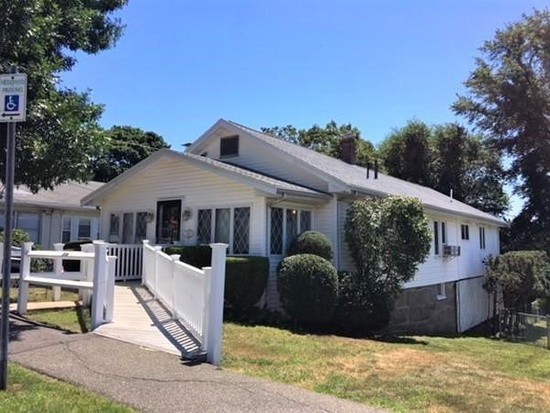
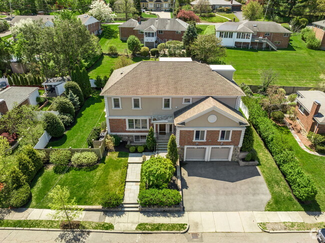
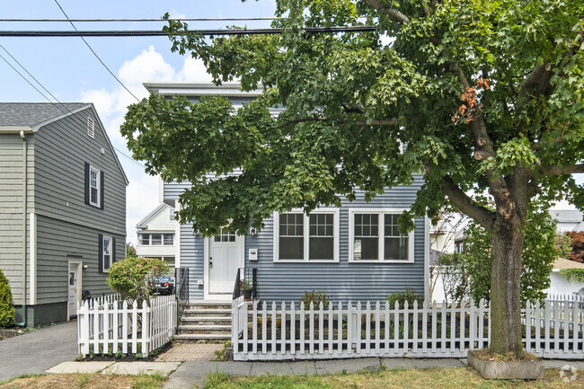
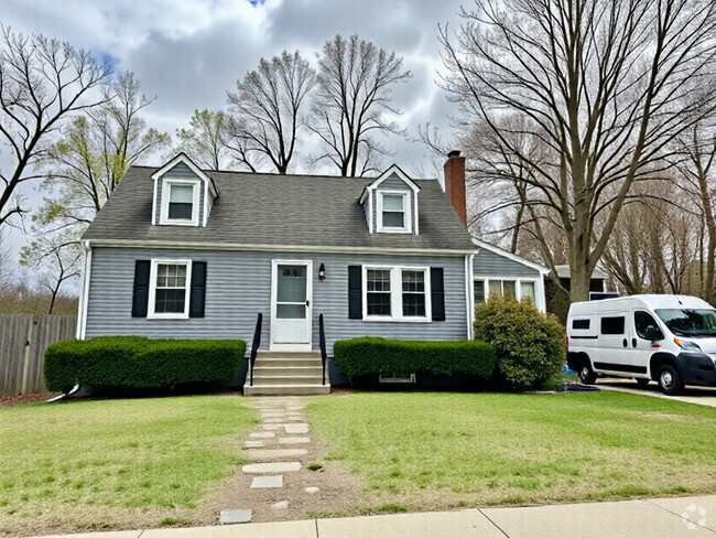
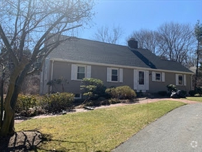
108 Connell St
Quincy, MA 02169
2 Weeks Ago
Favorites
108 Connell St

Favorites
Check Back Soon for Upcoming Availability
| Beds | Baths | Average SF |
|---|---|---|
| 3 Bedrooms 3 Bedrooms 3 Br | 2 Baths 2 Baths 2 Ba | 1,488 SF |
About This Property
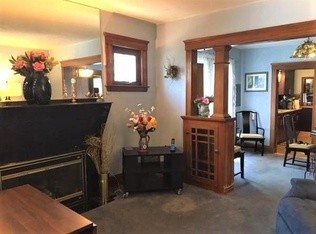
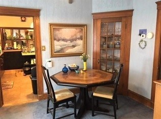
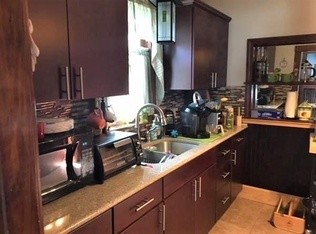
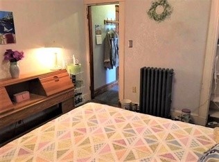
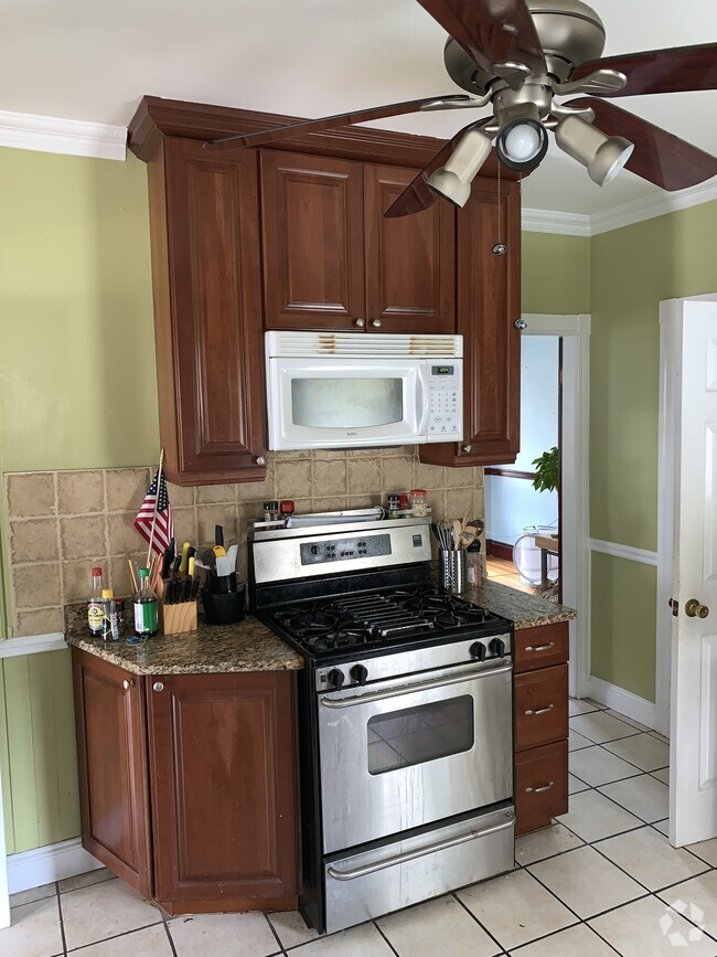
Desirable West Quincy neighborhood off Adams Street in the Bernazanni, Central and NQH school district, near the East Milton Lakin Square area. Oversized bungalow with 3-4 Bedrooms or 3 beds and family room. Fireplaced LR, some hardwood flooring and much original woodwork with built-ins including china cabinet. Newer, kitchen with granite countertops and an adjacent deck off the kitchen and two full baths. Two gas heating systems, one for original house and second for the large addition. Desirable West Quincy neighborhood off Adams Street in the Bernazanni, Central and NQH school district, near the East Milton Lakin Square area. Oversized bungalow with 3-4 Bedrooms or 3 beds and family room. Fireplaced LR, some hardwood flooring and much original woodwork with built-ins including china cabinet. Newer, kitchen with granite countertops and an adjacent deck off the kitchen and two full baths. Two gas heating systems, one for original house and second for the large addition.
108 Connell St is a house located in Norfolk County and the 02169 ZIP Code. This area is served by the Quincy attendance zone.
House Features
Air Conditioning
Dishwasher
Washer/Dryer Hookup
Hardwood Floors
- Washer/Dryer Hookup
- Air Conditioning
- Cable Ready
- Fireplace
- Wheelchair Accessible (Rooms)
- Dishwasher
- Microwave
- Refrigerator
- Hardwood Floors
- Laundry Facilities
- Storage Space
Fees and Policies
The fees below are based on community-supplied data and may exclude additional fees and utilities.
- Parking
-
Covered--
-
Garage--
Location
Get Directions
The Blue Hills Reservation takes up much of West Quincy. This 6,000-acre state park is one of the Boston area’s largest parcels of undeveloped land, culminating in its highest point, Great Blue Hill. Enjoy panoramic views from this vantage point and visit the historic Blue Hill Meteorological Observatory, founded by meteorologist and MIT grad, Abbott Lawrence Rotch in 1885. It is still active and is open to the public on weekends.
The north end of West Quincy is a wooded, attractive neighborhood with ample sidewalks that residents use for evening strolls or walking their dogs. The neighborhood provides ample mass transit and the Quincy Center subway station is only a mile or so to the east, making commuting throughout the Boston area a breeze.
While West Quincy is largely residential, you’ll find several shops and restaurants along Willard Street, as well as a few local favorites along Adams Street. Be sure to visit Brick & Beam, a rustic tavern, and Dairy Freeze for ice cream.
Learn more about living in West QuincyBelow are rent ranges for similar nearby apartments
Amenities
- Washer/Dryer Hookup
- Air Conditioning
- Cable Ready
- Fireplace
- Wheelchair Accessible (Rooms)
- Dishwasher
- Microwave
- Refrigerator
- Hardwood Floors
- Laundry Facilities
- Storage Space
Education
| Colleges & Universities | Distance | ||
|---|---|---|---|
| Colleges & Universities | Distance | ||
| Drive: | 10 min | 5.6 mi | |
| Drive: | 14 min | 5.6 mi | |
| Drive: | 14 min | 8.2 mi | |
| Drive: | 16 min | 8.7 mi |
108 Connell St is within 10 minutes or 5.6 miles from UMass Boston. It is also near Curry College and Wentworth Inst. of Technology.
Schools


Public Elementary School
Grades K-5
340 Students
Attendance Zone
Public Elementary School
Grades K-5
584 Students
Nearby
Public Middle School
Grades 6-8
647 Students
Attendance Zone
Public High School
Grades 9-12
1,476 Students
Attendance Zone
Private Elementary & Middle School
Grades PK-8
125 Students
Nearby
Private Middle & High School
Grades 6-12
59 Students
Nearby
School data provided by
 The GreatSchools Rating helps parents compare schools within a state based on a variety of school quality indicators and provides a helpful picture of how effectively each school serves all of its students. Ratings are on a scale of 1 (below average) to 10 (above average) and can include test scores, college readiness, academic progress, advanced courses, equity, discipline and attendance data. We also advise parents to visit schools, consider other information on school performance and programs, and consider family needs as part of the school selection process.
View GreatSchools Rating Methodology
View GreatSchools Rating Methodology
Transportation options available in Quincy include Wollaston Station, located 1.5 miles from 108 Connell St. 108 Connell St is near General Edward Lawrence Logan International, located 10.9 miles or 18 minutes away.
| Transit / Subway | Distance | ||
|---|---|---|---|
| Transit / Subway | Distance | ||
|
|
Drive: | 4 min | 1.5 mi |
|
|
Drive: | 5 min | 2.1 mi |
|
|
Drive: | 5 min | 2.6 mi |
|
|
Drive: | 6 min | 2.7 mi |
|
|
Drive: | 6 min | 3.0 mi |
| Commuter Rail | Distance | ||
|---|---|---|---|
| Commuter Rail | Distance | ||
|
|
Drive: | 4 min | 1.8 mi |
|
|
Drive: | 7 min | 3.9 mi |
| Drive: | 9 min | 4.4 mi | |
| Drive: | 9 min | 4.5 mi | |
|
|
Drive: | 8 min | 4.5 mi |
| Airports | Distance | ||
|---|---|---|---|
| Airports | Distance | ||
|
General Edward Lawrence Logan International
|
Drive: | 18 min | 10.9 mi |
Time and distance from 108 Connell St.
| Shopping Centers | Distance | ||
|---|---|---|---|
| Shopping Centers | Distance | ||
| Walk: | 8 min | 0.4 mi | |
| Drive: | 3 min | 1.6 mi | |
| Drive: | 4 min | 1.9 mi |
108 Connell St has 3 shopping centers within 1.9 miles, which is about a 4-minute walk. The miles and minutes will be for the farthest away property.
| Parks and Recreation | Distance | ||
|---|---|---|---|
| Parks and Recreation | Distance | ||
|
Adams National Historical Park
|
Drive: | 3 min | 1.3 mi |
|
Squantum Point Park
|
Drive: | 11 min | 4.4 mi |
|
Dorchester Shores Reservation
|
Drive: | 9 min | 5.5 mi |
|
Blue Hills Reservation
|
Drive: | 12 min | 7.5 mi |
|
Houghton's Pond Recreation Area
|
Drive: | 12 min | 7.5 mi |
108 Connell St has 5 parks within 7.5 miles, including Adams National Historical Park, Squantum Point Park, and Blue Hills Reservation.
| Hospitals | Distance | ||
|---|---|---|---|
| Hospitals | Distance | ||
| Drive: | 7 min | 3.0 mi | |
| Drive: | 6 min | 3.2 mi | |
| Drive: | 11 min | 7.0 mi |
108 Connell St has 3 hospitals within 7.0 miles, the nearest is Beth Israel Deaconess Hospital - Milton which is 3.0 miles away and a 7 minute drive.
You May Also Like
Similar Rentals Nearby
What Are Walk Score®, Transit Score®, and Bike Score® Ratings?
Walk Score® measures the walkability of any address. Transit Score® measures access to public transit. Bike Score® measures the bikeability of any address.
What is a Sound Score Rating?
A Sound Score Rating aggregates noise caused by vehicle traffic, airplane traffic and local sources

108 Connell St
Quincy, MA 02169