$1,700 / Month
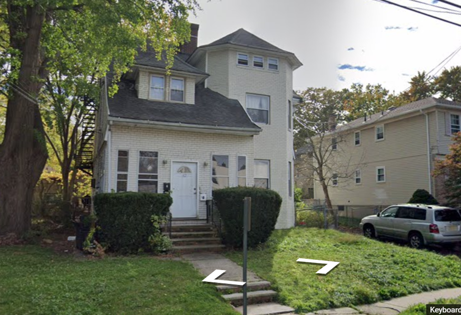
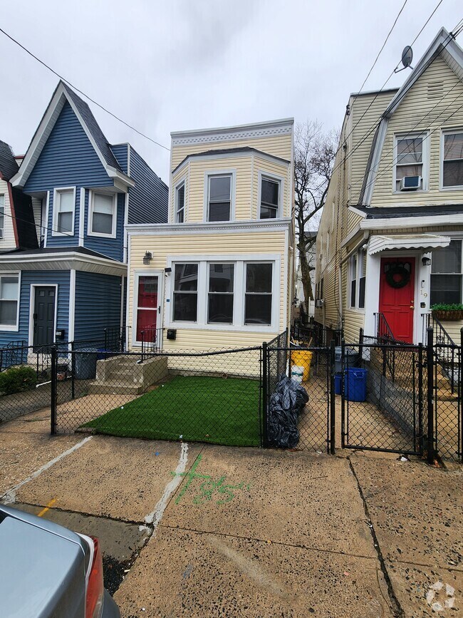
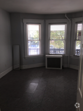
112 E 4th Ave Unit 2nd Floor
Roselle, NJ 07203
2 Weeks Ago
Favorites
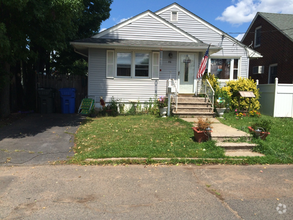
112 E 4th Ave

Favorites
Check Back Soon for Upcoming Availability
| Beds | Baths | Average SF |
|---|---|---|
| 2 Bedrooms 2 Bedrooms 2 Br | 1 Bath 1 Bath 1 Ba | 700 SF |
About This Property
Close to Shopping and NY Transportation. Eat in Kitchen. 3 Rooms (2 large , 1 small). 2nd Floor of a 3 family house. Parking available
112 E 4th Ave is a house located in Union County and the 07203 ZIP Code.
House Features
Tub/Shower
Heating
Eat-in Kitchen
Cable Ready
- Heating
- Cable Ready
- Tub/Shower
- Eat-in Kitchen
- Kitchen
Fees and Policies
The fees below are based on community-supplied data and may exclude additional fees and utilities.
- Cats Allowed
-
Fees not specified
-
Weight limit--
-
Pet Limit--
- Parking
-
Street--
Details
Utilities Included
-
Gas
-
Water
-
Heat
-
Trash Removal
-
Sewer
Location
Get Directions
Ideally located about 10 miles southwest of Newark and 18 miles from New York City, Roselle is a cozy borough for those looking for a quieter place to call home. First settled around 1664, Roselle was settled by farmers looking for better farmland. It was part of the first New Jersey settlement called Elizabethtown. The borough was officially incorporated in 1894 as Roselle.
Today, this terrific community features beautiful parks and great shopping. Warinanco Park, the borough's largest park, offers ball fields, a running track, a playground, pedal boats, an ice skating rink, a fitness trail, a bicycle path, fishing, a spray pool, tennis courts, picnic areas, and shuffleboard. Roselle's tree-lined streets are mainly residential, with a shopping district located between Westfield Avenue and West 1st Avenue.
Learn more about living in Roselle
Amenities
- Heating
- Cable Ready
- Tub/Shower
- Eat-in Kitchen
- Kitchen
Expenses
Utilities Included
Gas, Water, Heat, Trash Removal, Sewer
Included
Education
| Colleges & Universities | Distance | ||
|---|---|---|---|
| Colleges & Universities | Distance | ||
| Drive: | 6 min | 2.7 mi | |
| Drive: | 8 min | 3.2 mi | |
| Drive: | 12 min | 4.0 mi | |
| Drive: | 19 min | 10.1 mi |
112 E 4th Ave is within 6 minutes or 2.7 miles from Union County Coll., Elizabeth. It is also near Kean University and Union County College, Cranford.
Transportation options available in Roselle include Military Park, located 9.0 miles from 112 E 4th Ave. 112 E 4th Ave is near Newark Liberty International, located 12.2 miles or 17 minutes away, and Laguardia, located 27.4 miles or 52 minutes away.
| Transit / Subway | Distance | ||
|---|---|---|---|
| Transit / Subway | Distance | ||
|
|
Drive: | 16 min | 9.0 mi |
|
|
Drive: | 17 min | 9.6 mi |
| Drive: | 19 min | 10.0 mi | |
|
|
Drive: | 17 min | 10.5 mi |
|
|
Drive: | 17 min | 11.0 mi |
| Commuter Rail | Distance | ||
|---|---|---|---|
| Commuter Rail | Distance | ||
|
|
Drive: | 3 min | 1.2 mi |
|
|
Drive: | 5 min | 2.3 mi |
|
|
Drive: | 6 min | 2.6 mi |
|
|
Drive: | 7 min | 2.9 mi |
|
|
Drive: | 8 min | 3.6 mi |
| Airports | Distance | ||
|---|---|---|---|
| Airports | Distance | ||
|
Newark Liberty International
|
Drive: | 17 min | 12.2 mi |
|
Laguardia
|
Drive: | 52 min | 27.4 mi |
Time and distance from 112 E 4th Ave.
| Shopping Centers | Distance | ||
|---|---|---|---|
| Shopping Centers | Distance | ||
| Walk: | 19 min | 1.0 mi | |
| Drive: | 3 min | 1.3 mi | |
| Drive: | 4 min | 1.3 mi |
112 E 4th Ave has 3 shopping centers within 1.3 miles, which is about a 4-minute walk. The miles and minutes will be for the farthest away property.
| Parks and Recreation | Distance | ||
|---|---|---|---|
| Parks and Recreation | Distance | ||
|
William Miller Sperry Observatory
|
Drive: | 10 min | 3.8 mi |
|
Hawk Rise Sanctuary
|
Drive: | 12 min | 4.7 mi |
|
Merrill Park
|
Drive: | 15 min | 6.4 mi |
|
Staten Island Industrial Park
|
Drive: | 14 min | 7.4 mi |
|
Liberty State Park
|
Drive: | 16 min | 7.5 mi |
112 E 4th Ave has 5 parks within 7.5 miles, including William Miller Sperry Observatory, Hawk Rise Sanctuary, and Merrill Park.
| Hospitals | Distance | ||
|---|---|---|---|
| Hospitals | Distance | ||
| Drive: | 8 min | 3.0 mi | |
| Drive: | 9 min | 3.9 mi | |
| Drive: | 12 min | 7.6 mi |
112 E 4th Ave has 3 hospitals within 7.6 miles, the nearest is Trinitas Regional Medical Center which is 3.0 miles away and a 8 minute drive.
| Military Bases | Distance | ||
|---|---|---|---|
| Military Bases | Distance | ||
| Drive: | 17 min | 7.3 mi | |
| Drive: | 15 min | 7.6 mi | |
| Drive: | 23 min | 16.0 mi |
112 E 4th Ave has 3 military bases within 16.0 miles, the nearest is Tamdques Reservation which is 7.3 miles away and a 17 minute drive.
You May Also Like
Similar Rentals Nearby

What Are Walk Score®, Transit Score®, and Bike Score® Ratings?
Walk Score® measures the walkability of any address. Transit Score® measures access to public transit. Bike Score® measures the bikeability of any address.
What is a Sound Score Rating?
A Sound Score Rating aggregates noise caused by vehicle traffic, airplane traffic and local sources

112 E 4th Ave
Roselle, NJ 07203