
$1,950 / Month
1131 Lincoln Ave
Saint Paul, MN 55105
2 Days Ago
Favorites
-
Bedrooms
2
-
Bathrooms
1
-
Square Feet
1,500 sq ft
-
Available
Available Jul 1
Highlights
- Patio
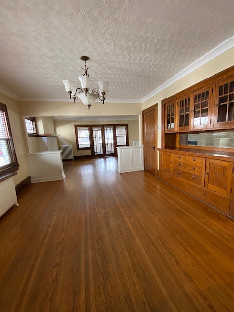
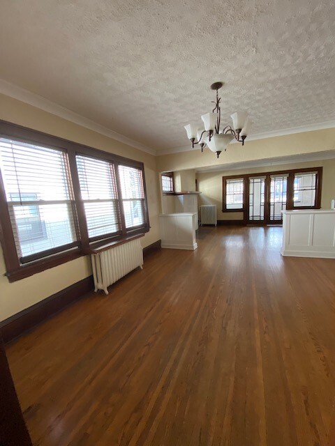
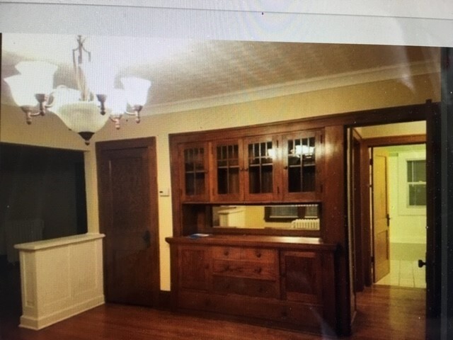
- Hardwood Floors
- Yard
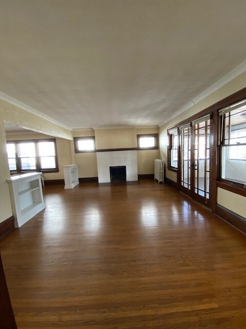
- Fireplace
- Smoke Free
1131 Lincoln Ave

Favorites
About This Home
12 Month Lease,
$1,950 deposit,
Available Jul 1
*************** COMING SOON! ************* Nice and spacious two bedrooms apartment in Crocus Hill St. Paul. One block from a bus line, walk to Kowalski, Grand Avenue restaurants, Starbucks and shop from local businesses. Close to colleges Mitchell Hamline School of Law, Macalester and University of St. Thomas.
1131 Lincoln Ave is a townhome located in Ramsey County and the 55105 ZIP Code.
* Price shown is base rent and may not include non-optional fees and utilities.
Price, availability, fees, and any applicable rent special are subject to change without notice.
* Square footage definitions vary. Displayed square footage is approximate.
Townhome Features
Dishwasher
Hardwood Floors
Fireplace
Smoke Free
- Smoke Free
- Fireplace
- Dishwasher
- Hardwood Floors
- Laundry Facilities
- Storage Space
- Patio
- Yard
Fees and Policies
The fees below are based on community-supplied data and may exclude additional fees and utilities.
- Parking
-
Garage$150/mo
Details
Utilities Included
-
Water
-
Trash Removal
Contact
- Contact
Location
Get Directions
Situated in beautiful Saint Paul along the eastern border of Minneapolis, the Summit Hill neighborhood features oak-lined boulevards and historic Victorian mansions. Considering its location three miles west of downtown Saint Paul and eight miles east of downtown Minneapolis, this area an ideal neighborhood for commuters to either city. The centerpieces of the pedestrian-friendly neighborhood are its stately cathedral and its bustling commercial center along Grand Avenue. Summit Avenue was recently named one of America’s 10 Great Streets by the American Planning Association.
Home to locally and nationally owned restaurants, galleries and businesses, Summit Hill provides a safe, historic and vibrant community for both homeowners and renters.
Learn more about living in Summit Hill
Education
| Colleges & Universities | Distance | ||
|---|---|---|---|
| Colleges & Universities | Distance | ||
| Walk: | 19 min | 1.0 mi | |
| Drive: | 2 min | 1.1 mi | |
| Drive: | 6 min | 2.5 mi | |
| Drive: | 7 min | 2.9 mi |
1131 Lincoln Ave is within 19 minutes or 1.0 miles from Concordia Univ.-Saint Paul. It is also near Macalester College and Saint Paul College.
Transportation options available in Saint Paul include Lexington Pkwy Station, located 1.3 miles from 1131 Lincoln Ave. 1131 Lincoln Ave is near Minneapolis-St Paul International/Wold-Chamberlain, located 7.0 miles or 14 minutes away.
| Transit / Subway | Distance | ||
|---|---|---|---|
| Transit / Subway | Distance | ||
| Drive: | 4 min | 1.3 mi | |
| Drive: | 4 min | 1.6 mi | |
| Drive: | 4 min | 2.0 mi | |
| Drive: | 4 min | 2.1 mi | |
| Drive: | 4 min | 2.1 mi |
| Commuter Rail | Distance | ||
|---|---|---|---|
| Commuter Rail | Distance | ||
|
|
Drive: | 7 min | 3.5 mi |
|
|
Drive: | 17 min | 8.3 mi |
|
|
Drive: | 25 min | 16.9 mi |
|
|
Drive: | 35 min | 25.7 mi |
|
|
Drive: | 36 min | 27.4 mi |
| Airports | Distance | ||
|---|---|---|---|
| Airports | Distance | ||
|
Minneapolis-St Paul International/Wold-Chamberlain
|
Drive: | 14 min | 7.0 mi |
Time and distance from 1131 Lincoln Ave.
| Shopping Centers | Distance | ||
|---|---|---|---|
| Shopping Centers | Distance | ||
| Walk: | 11 min | 0.6 mi | |
| Walk: | 11 min | 0.6 mi | |
| Walk: | 12 min | 0.6 mi |
1131 Lincoln Ave has 3 shopping centers within 0.6 mile, which is about a 12-minute walk. The miles and minutes will be for the farthest away property.
| Parks and Recreation | Distance | ||
|---|---|---|---|
| Parks and Recreation | Distance | ||
|
Macalester College Observatory
|
Drive: | 2 min | 1.2 mi |
|
Highland Park and Golf Course
|
Drive: | 5 min | 2.2 mi |
|
Irvine Park
|
Drive: | 5 min | 2.4 mi |
|
Western Park
|
Drive: | 6 min | 3.1 mi |
|
Cherokee Regional Park
|
Drive: | 8 min | 3.6 mi |
1131 Lincoln Ave has 5 parks within 3.6 miles, including Macalester College Observatory, Highland Park and Golf Course, and Irvine Park.
| Hospitals | Distance | ||
|---|---|---|---|
| Hospitals | Distance | ||
| Drive: | 4 min | 2.1 mi | |
| Drive: | 6 min | 3.2 mi | |
| Drive: | 7 min | 3.7 mi |
1131 Lincoln Ave has 3 hospitals within 3.7 miles, the nearest is Allina United Hospital which is 2.1 miles away and a 4 minute drive.
| Military Bases | Distance | ||
|---|---|---|---|
| Military Bases | Distance | ||
| Drive: | 13 min | 5.7 mi |
1131 Lincoln Ave is 5.7 miles and a 13 minute drive from Fort Snelling Military Reservation.
Amenities
- Smoke Free
- Fireplace
- Dishwasher
- Hardwood Floors
- Laundry Facilities
- Storage Space
- Patio
- Yard
1131 Lincoln Ave Photos
-
Dining
-
Dining
-
-
Living
-
-
Fireplace
-
-
Kitchen
-
Kitchen
What Are Walk Score®, Transit Score®, and Bike Score® Ratings?
Walk Score® measures the walkability of any address. Transit Score® measures access to public transit. Bike Score® measures the bikeability of any address.
What is a Sound Score Rating?
A Sound Score Rating aggregates noise caused by vehicle traffic, airplane traffic and local sources

1131 Lincoln Ave
Saint Paul, MN 55105