1216 N La Cienega Blvd
1216 N La Cienega Blvd,
West Hollywood,
CA
90069
2 Weeks Ago
Favorites
1216 N La Cienega Blvd

Favorites
Check Back Soon for Upcoming Availability
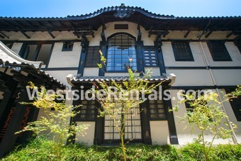
About 1216 N La Cienega Blvd West Hollywood, CA 90069
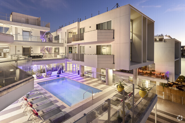
Amazing Renovated West Hollywood Apts in Historic Building Upper units 1-car Subterranean Parking. Enter the gates into the lush gardens of The Historical Lotus Apartments and step into your newly renovated home! This Hollywood landmark has been beautifully updated while still maintaining it's original charm and luxurious curb appeal. Featuring hardwood floors through out, french windows, high ceilings, spacious layout, new stainless steel appliances, washer/dryer in unit, large closets, security system installed, gated parking, and much more! Located in the heart of West Hollywood; walking distance to countless hot spots including the new James Hotel, Standard Hotel, WeHo Bistro, The Mondrian, Barney's Beanery, Katana, Sunset Plaza, Equinox, Crunch, Trader Joe's, Gelson's, Shake Shack, Palihouse, and the list goes on. Multiple units available now!
1216 N La Cienega Blvd is an apartment community located in Los Angeles County and the 90069 ZIP Code.
Apartment Features
- Air Conditioning
- Microwave
- Refrigerator
Fees and Policies
The fees below are based on community-supplied data and may exclude additional fees and utilities.
- Dogs Allowed
-
Pet deposit$0
- Cats Allowed
-
Pet deposit$0
Details
Property Information
-
7 units
Property Address:
1216 N La Cienega Blvd,
West Hollywood,
CA
90069
It's the Sunset Strip, Santa Monica Boulevard, the Roxy Theater, and the Comedy Club. Everything you love about living in LA is in West Hollywood. It's the most pedestrian-friendly city in California, and the nightlife is unrivaled -- even for LA. West Hollywood's neighborhoods are equally famous -- West Hollywood West and the Norma Triangle are located here.
The Pacific Design Center is a West Hollywood landmark -- a giant 1.6-million square foot design community with 100 showrooms displaying everything from furniture to contemporary art. The PDC also contains the SiverScreen Theater and the Red Seven by Wolfgang Puck restaurant. It is located on Melrose Avenue, which is lined with boutiques, restaurants, and antique stores. West Hollywood is home to several legendary music venues, including Whisky a Go Go, the Roxy Theatre, and the House of Blues.
Learn more about living in West Hollywood
Amenities
- Air Conditioning
- Microwave
- Refrigerator
Education
| Colleges & Universities | Distance | ||
|---|---|---|---|
| Colleges & Universities | Distance | ||
| Drive: | 6 min | 3.2 mi | |
| Drive: | 7 min | 3.6 mi | |
| Drive: | 12 min | 5.6 mi | |
| Drive: | 14 min | 7.3 mi |
1216 N La Cienega Blvd is within 6 minutes or 3.2 miles from Musicians Institute. It is also near Los Angeles Film School and UCLA.
Transportation options available in West Hollywood include Hollywood/Highland Station, located 3.1 miles from 1216 N La Cienega Blvd. 1216 N La Cienega Blvd is near Bob Hope, located 11.5 miles or 22 minutes away, and Los Angeles International, located 12.1 miles or 23 minutes away.
| Transit / Subway | Distance | ||
|---|---|---|---|
| Transit / Subway | Distance | ||
|
|
Drive: | 6 min | 3.1 mi |
|
|
Drive: | 7 min | 3.8 mi |
|
|
Drive: | 9 min | 4.8 mi |
|
|
Drive: | 10 min | 5.7 mi |
|
|
Drive: | 12 min | 6.5 mi |
| Commuter Rail | Distance | ||
|---|---|---|---|
| Commuter Rail | Distance | ||
|
|
Drive: | 17 min | 9.1 mi |
|
|
Drive: | 19 min | 9.4 mi |
|
|
Drive: | 17 min | 9.9 mi |
|
|
Drive: | 20 min | 10.4 mi |
| Drive: | 21 min | 10.9 mi |
| Airports | Distance | ||
|---|---|---|---|
| Airports | Distance | ||
|
Bob Hope
|
Drive: | 22 min | 11.5 mi |
|
Los Angeles International
|
Drive: | 23 min | 12.1 mi |
Time and distance from 1216 N La Cienega Blvd.
| Shopping Centers | Distance | ||
|---|---|---|---|
| Shopping Centers | Distance | ||
| Walk: | 5 min | 0.3 mi | |
| Walk: | 6 min | 0.3 mi | |
| Walk: | 9 min | 0.5 mi |
1216 N La Cienega Blvd has 3 shopping centers within 0.5 mile, which is about a 9-minute walk. The miles and minutes will be for the farthest away property.
| Parks and Recreation | Distance | ||
|---|---|---|---|
| Parks and Recreation | Distance | ||
|
Runyon Canyon
|
Drive: | 6 min | 2.2 mi |
|
Zimmer Children's Museum
|
Drive: | 5 min | 2.4 mi |
|
Virginia Robinson Gardens
|
Drive: | 7 min | 2.9 mi |
|
La Brea Tar Pits
|
Drive: | 6 min | 3.1 mi |
|
Franklin Canyon Park
|
Drive: | 15 min | 4.8 mi |
1216 N La Cienega Blvd has 5 parks within 4.8 miles, including Zimmer Children's Museum, Runyon Canyon, and Virginia Robinson Gardens.
| Hospitals | Distance | ||
|---|---|---|---|
| Hospitals | Distance | ||
| Drive: | 3 min | 1.5 mi | |
| Drive: | 5 min | 2.9 mi | |
| Drive: | 6 min | 3.0 mi |
1216 N La Cienega Blvd has 3 hospitals within 3.0 miles, the nearest is Cedars-Sinai Medical Center which is 1.5 miles away and a 3 minutes drive.
| Military Bases | Distance | ||
|---|---|---|---|
| Military Bases | Distance | ||
| Drive: | 23 min | 13.8 mi |
1216 N La Cienega Blvd is 13.8 miles and a 23 minutes from Los Angeles Air Force Base.
You May Also Like
Similar Rentals Nearby


What Are Walk Score®, Transit Score®, and Bike Score® Ratings?
Walk Score® measures the walkability of any address. Transit Score® measures access to public transit. Bike Score® measures the bikeability of any address.
What is a Sound Score Rating?
A Sound Score Rating aggregates noise caused by vehicle traffic, airplane traffic and local sources