$3,000 / Month
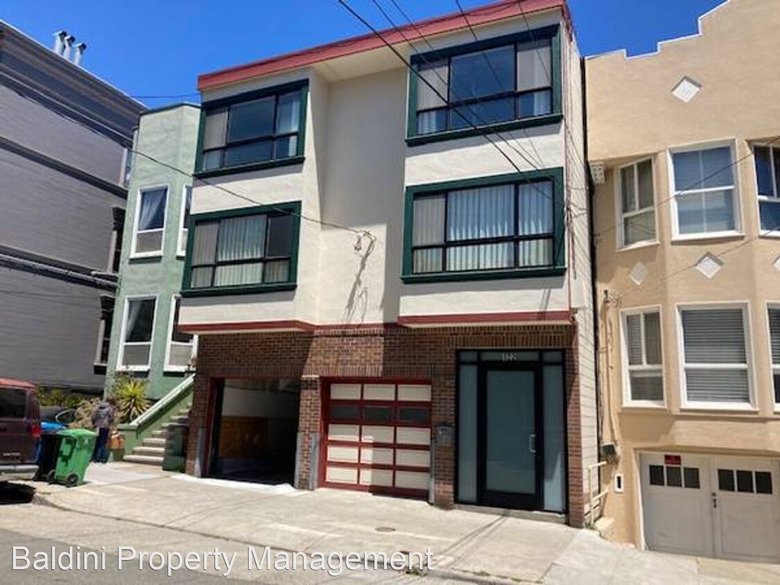
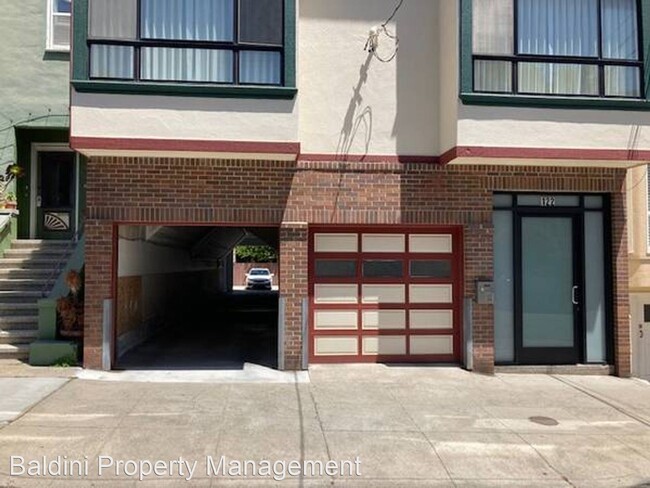
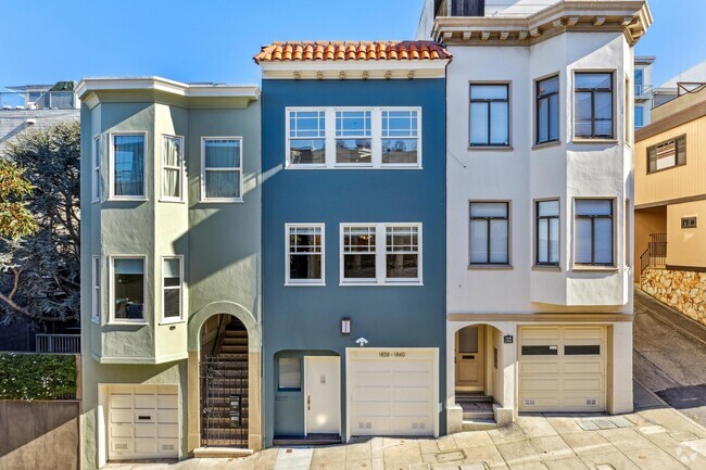
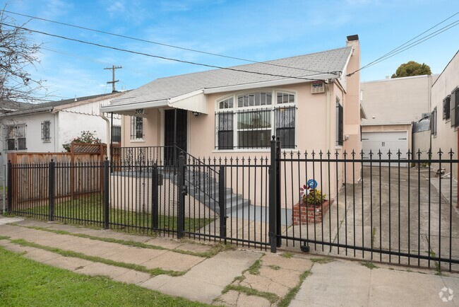
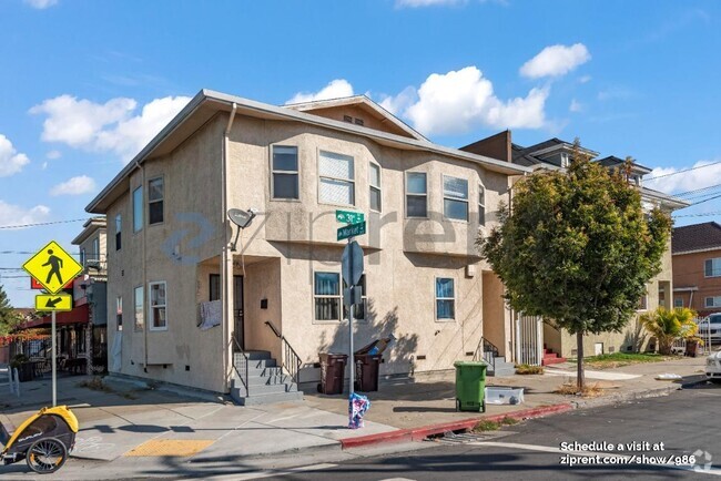
122 29th St
San Francisco, CA 94110
2 Weeks Ago
Favorites
122 29th St

Favorites
Check Back Soon for Upcoming Availability
| Beds | Baths | Average SF |
|---|---|---|
| 2 Bedrooms 2 Bedrooms 2 Br | 1 Bath 1 Bath 1 Ba | — |
About This Property
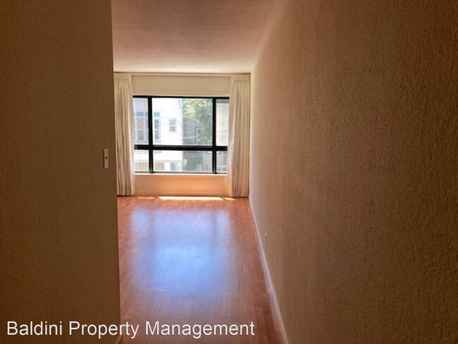
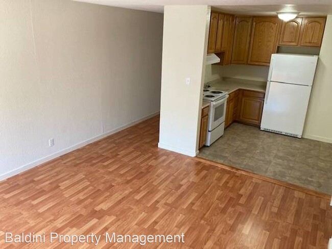
(415) 587-4212 - CLEANEST, 2BD/1BA, PKG, IN THE CITY ! - Impeccable building, incredible location !!! This super clean , super bright 2bd/1ba unit is strategically located in the all access portion of Noe Valley. Short hop to anywhere into the City or a minute to freeways heading South. Short walk to the Mission, and amazing restaurants,coffee shops. Mitchell's Ice Cream right around the corner. Surrounded by bus routes. Best weather in the City. Nice flat area, great for walking. 1 car secured parking with interior building access. Call for a private showing appointment !!! (RLNE6708902)
122 29th St is a house located in San Francisco County and the 94110 ZIP Code. This area is served by the San Francisco Unified attendance zone.
Location
Get Directions
Noe Valley is in central San Francisco, encompassed by modern comforts. Many renters choose Noe Valley apartments because of the convenient access to city transit. The SFMTA Light Rails pick up along Church Street, and BART 24th Street Mission Station is a short walk away.
Most of the neighborhood’s bars, eateries, and bakeries are found along 24th Street. A couple of green spaces are in Noe Valley, such as Upper Noe Recreation Center and Noe Valley Courts. Residents enjoy hiking along the trails at nearby Twin Peaks and perusing the luxury jewelry shops and boutiques in town3.
Learn more about living in Noe ValleyBelow are rent ranges for similar nearby apartments
Education
| Colleges & Universities | Distance | ||
|---|---|---|---|
| Colleges & Universities | Distance | ||
| Drive: | 5 min | 2.5 mi | |
| Drive: | 9 min | 2.9 mi | |
| Drive: | 11 min | 3.8 mi | |
| Drive: | 8 min | 5.6 mi |
122 29th St is within 5 minutes or 2.5 miles from City College of San Francisco. It is also near California College of the Arts and UC San Francisco, Mission Bay.
Schools


Public Elementary School
Grades K-5
Nearby
Public Elementary School
Grades K-5
488 Students
Attendance Zone
Public Middle & High School
Grades 8-12
401 Students
Nearby
Public Middle School
Grades 6-8
485 Students
Attendance Zone
Private Elementary & Middle School
Grades PK-8
476 Students
Nearby
Private Elementary & Middle School
Grades K-8
207 Students
Nearby
Private High School
Grades 9-12
364 Students
Nearby
School data provided by
 The GreatSchools Rating helps parents compare schools within a state based on a variety of school quality indicators and provides a helpful picture of how effectively each school serves all of its students. Ratings are on a scale of 1 (below average) to 10 (above average) and can include test scores, college readiness, academic progress, advanced courses, equity, discipline and attendance data. We also advise parents to visit schools, consider other information on school performance and programs, and consider family needs as part of the school selection process.
View GreatSchools Rating Methodology
View GreatSchools Rating Methodology
Transportation options available in San Francisco include 30Th Street And Dolores, located 0.2 mile from 122 29th St. 122 29th St is near San Francisco International, located 12.7 miles or 19 minutes away, and Metro Oakland International, located 22.8 miles or 36 minutes away.
| Transit / Subway | Distance | ||
|---|---|---|---|
| Transit / Subway | Distance | ||
|
|
Walk: | 3 min | 0.2 mi |
|
|
Walk: | 3 min | 0.2 mi |
|
|
Walk: | 5 min | 0.3 mi |
|
|
Walk: | 6 min | 0.3 mi |
|
|
Walk: | 8 min | 0.4 mi |
| Commuter Rail | Distance | ||
|---|---|---|---|
| Commuter Rail | Distance | ||
| Drive: | 8 min | 3.5 mi | |
| Drive: | 9 min | 4.4 mi | |
| Drive: | 8 min | 4.8 mi | |
| Drive: | 14 min | 9.3 mi | |
| Drive: | 15 min | 11.7 mi |
| Airports | Distance | ||
|---|---|---|---|
| Airports | Distance | ||
|
San Francisco International
|
Drive: | 19 min | 12.7 mi |
|
Metro Oakland International
|
Drive: | 36 min | 22.8 mi |
Time and distance from 122 29th St.
| Shopping Centers | Distance | ||
|---|---|---|---|
| Shopping Centers | Distance | ||
| Walk: | 8 min | 0.5 mi | |
| Drive: | 4 min | 1.1 mi | |
| Drive: | 6 min | 1.9 mi |
122 29th St has 3 shopping centers within 1.9 miles, which is about a 6-minute walk. The miles and minutes will be for the farthest away property.
| Parks and Recreation | Distance | ||
|---|---|---|---|
| Parks and Recreation | Distance | ||
|
Buena Vista Park
|
Drive: | 7 min | 2.6 mi |
|
Randall Museum
|
Drive: | 8 min | 2.8 mi |
|
Heron's Head Park
|
Drive: | 9 min | 3.2 mi |
|
Children's Creativity Museum
|
Drive: | 10 min | 3.5 mi |
|
Conservatory of Flowers
|
Drive: | 10 min | 4.0 mi |
122 29th St has 5 parks within 4.0 miles, including Randall Museum, Buena Vista Park, and Heron's Head Park.
| Hospitals | Distance | ||
|---|---|---|---|
| Hospitals | Distance | ||
| Walk: | 7 min | 0.4 mi | |
| Drive: | 3 min | 1.5 mi | |
| Drive: | 5 min | 1.8 mi |
122 29th St has 3 hospitals within 1.8 miles, the nearest is California Pacific Medical Center - Mission Bernal which is 0.4 mile away and a 7 minute walk.
| Military Bases | Distance | ||
|---|---|---|---|
| Military Bases | Distance | ||
| Drive: | 18 min | 6.9 mi | |
| Drive: | 19 min | 7.4 mi |
122 29th St is 6.9 miles from East Fort Miley, and is convenient to other military bases, including West Fort Miley.
You May Also Like
Similar Rentals Nearby

What Are Walk Score®, Transit Score®, and Bike Score® Ratings?
Walk Score® measures the walkability of any address. Transit Score® measures access to public transit. Bike Score® measures the bikeability of any address.
What is a Sound Score Rating?
A Sound Score Rating aggregates noise caused by vehicle traffic, airplane traffic and local sources

122 29th St
San Francisco, CA 94110