-
Monthly Rent
$1,888
-
Bedrooms
4 bd
-
Bathrooms
3 ba
-
Square Feet
Details

About This Property
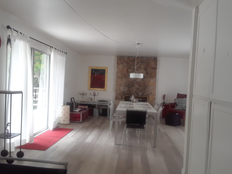
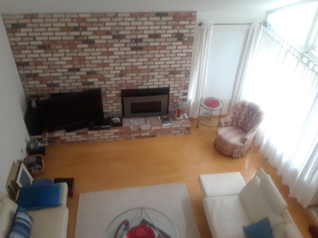
Property Id: 947553 Excellent Location Easy access to 280/foothill expressway Upscale neighborhood Stanford, Apple , Google, Tesla ....NEAR By 4 Bedroom 3 Full bathroom One Master Bedroom Private Bath All Hardwood Floor big Back Yard available 3 Single professional engineers Seeking One Single professional Housemate Non-smoker, No Pet, No drama, No Drug, GOOD Credit Text or Email your professional profile or linkedin Appt PER VIEWING Pls text to confirm Sunday (text Only)
1221 St Matthew Way is a house located in Santa Clara County and the 94024 ZIP Code. This area is served by the Cupertino Union attendance zone.
House Features
Washer/Dryer
Dishwasher
Hardwood Floors
Microwave
- Washer/Dryer
- Cable Ready
- Security System
- Fireplace
- Dishwasher
- Disposal
- Microwave
- Oven
- Refrigerator
- Hardwood Floors
- Tile Floors
- Vaulted Ceiling
- Furnished
- Bicycle Storage
- Fenced Lot
- Lawn
Fees and Policies
The fees below are based on community-supplied data and may exclude additional fees and utilities.
- Parking
-
Garage--
Details
Property Information
-
Furnished Units Available
 This Property
 Available Property
- Washer/Dryer
- Cable Ready
- Security System
- Fireplace
- Dishwasher
- Disposal
- Microwave
- Oven
- Refrigerator
- Hardwood Floors
- Tile Floors
- Vaulted Ceiling
- Furnished
- Fenced Lot
- Lawn
- Bicycle Storage
Los Altos likes to strike a balance between the urbanized atmosphere of the Bay Area and the more rural environment of the wide-open spaces bordering the city’s southwest side. While it is mainly a residential community, the downtown area surrounding Main Street is a walkable shopping and dining district with tree-lined streets and several public parks nearby. The crime rate is quite low and the local schools are among the highest-performing in the state. Palo Alto is right next door and San Jose just a few minutes down the road, giving Los Altos residents convenient access to Silicon Valley’s greatest amenities.
Learn more about living in Los Altos| Colleges & Universities | Distance | ||
|---|---|---|---|
| Colleges & Universities | Distance | ||
| Drive: | 8 min | 3.6 mi | |
| Drive: | 9 min | 4.2 mi | |
| Drive: | 14 min | 6.7 mi | |
| Drive: | 15 min | 8.6 mi |
Transportation options available in Los Altos include Whisman Station, located 6.3 miles from 1221 St Matthew Way. 1221 St Matthew Way is near Norman Y Mineta San Jose International, located 13.3 miles or 20 minutes away, and San Francisco International, located 31.1 miles or 40 minutes away.
| Transit / Subway | Distance | ||
|---|---|---|---|
| Transit / Subway | Distance | ||
|
|
Drive: | 11 min | 6.3 mi |
|
|
Drive: | 10 min | 6.4 mi |
|
|
Drive: | 11 min | 6.6 mi |
|
|
Drive: | 13 min | 8.0 mi |
|
|
Drive: | 13 min | 8.3 mi |
| Commuter Rail | Distance | ||
|---|---|---|---|
| Commuter Rail | Distance | ||
| Drive: | 13 min | 5.4 mi | |
| Drive: | 11 min | 5.7 mi | |
| Drive: | 10 min | 6.1 mi | |
| Drive: | 17 min | 8.1 mi | |
| Drive: | 16 min | 9.7 mi |
| Airports | Distance | ||
|---|---|---|---|
| Airports | Distance | ||
|
Norman Y Mineta San Jose International
|
Drive: | 20 min | 13.3 mi |
|
San Francisco International
|
Drive: | 40 min | 31.1 mi |
Time and distance from 1221 St Matthew Way.
| Shopping Centers | Distance | ||
|---|---|---|---|
| Shopping Centers | Distance | ||
| Drive: | 3 min | 1.3 mi | |
| Drive: | 4 min | 2.0 mi | |
| Drive: | 6 min | 2.5 mi |
| Parks and Recreation | Distance | ||
|---|---|---|---|
| Parks and Recreation | Distance | ||
|
Deer Hollow Farm
|
Drive: | 7 min | 2.8 mi |
|
Rancho San Antonio County Park
|
Drive: | 8 min | 2.9 mi |
|
McClellan Ranch Park
|
Drive: | 7 min | 3.2 mi |
|
Fujitsu Planetarium
|
Drive: | 8 min | 3.6 mi |
|
Fremont Older Open Space Preserve
|
Drive: | 14 min | 5.5 mi |
| Hospitals | Distance | ||
|---|---|---|---|
| Hospitals | Distance | ||
| Drive: | 6 min | 2.1 mi | |
| Drive: | 11 min | 6.5 mi | |
| Drive: | 19 min | 11.5 mi |
| Military Bases | Distance | ||
|---|---|---|---|
| Military Bases | Distance | ||
| Drive: | 15 min | 8.1 mi |
You May Also Like
What Are Walk Score®, Transit Score®, and Bike Score® Ratings?
Walk Score® measures the walkability of any address. Transit Score® measures access to public transit. Bike Score® measures the bikeability of any address.
What is a Sound Score Rating?
A Sound Score Rating aggregates noise caused by vehicle traffic, airplane traffic and local sources


