


$1,000 / Month
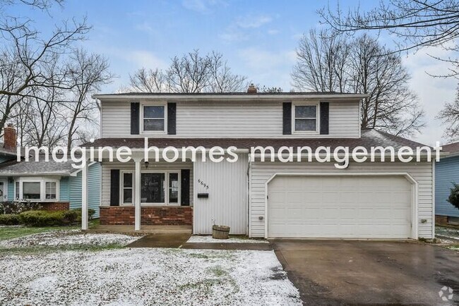
12301 Forest Ave Unit Lower
Cleveland, OH 44120
Today
Favorites
440-332-7132
-
Bedrooms
4
-
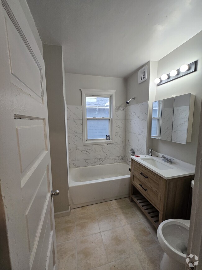
Bathrooms
1
-
Square Feet
1,150 sq ft
-
Available
Available Now
12301 Forest Ave Unit Lower

Favorites
About This Home
Available Now
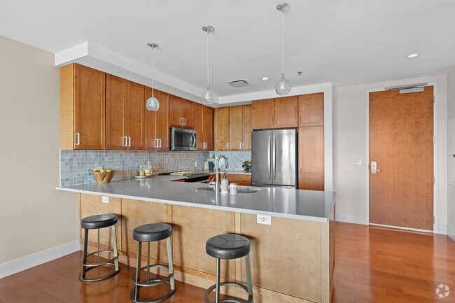
SECTION 8 / CMHA VOUCHERS ACCEPTED. Looking for extra space? This beautifully renovated 4-bedroom home is ideal for families, offering a bright and spacious layout with modern updates throughout. The kitchen boasts a convenient rear entry, making grocery trips a breeze, while the large open-concept living area is perfect for relaxing or entertaining. Enjoy the convenience of a prime location—just a short walk to shopping centers, schools, and everyday essentials. Plus, with easy access to Kinsman, commuting to downtown is quick and stress-free! Key Details: - Rent: $1200/month - Security Deposit: $1200 - Utilities: Residents are responsible for gas and electric, while the landlord pays water and sewer. - Lease term: One-year initial lease, converting to month-to-month unless a new annual lease is signed. - Property Care: Tenants are expected to maintain both the interior and exterior, including leaf and snow removal. - Payment: Rent is due on the 1st of each month. Don’t miss out on this fantastic opportunity to settle into a freshly updated home with plenty of space for the whole family. Schedule a tour today and make this wonderful house your next home!
12301 Forest Ave is an apartment community located in Cuyahoga County and the 44120 ZIP Code.
* Price shown is base rent and may not include non-optional fees and utilities.
Price, availability, fees, and any applicable rent special are subject to change without notice.
* Square footage definitions vary. Displayed square footage is approximate.
Features
- Smoke Free
Fees and Policies
The fees below are based on community-supplied data and may exclude additional fees and utilities.
Details
Utilities Included
-
Sewer
Contact
- Listed by PMI CLE
- Phone Number
- Contact
Location
Get Directions
Amenities
- Smoke Free
Expenses
Utilities Included
Sewer
Included
Known as one of Cleveland, Ohio's, premiere shopping and dining districts, the Buckeye-Shaker neighborhood sits on the east side of the city and contains the old Buckeye, Larchmere, and Shaker Square areas. Originally known as Little Hungary, the area of Cleveland in and around Buckeye Road contains many older single-family homes and apartment buildings. The Larchmere and Shaker Square sections of the neighborhood hold a large selection of shops and restaurants, all within easy walking distance of one another.
Bordered by University Circle to the north, Shaker Heights to the east, Mount Pleasant to the south, and Woodland Hills to the west, the Buckeye-Shaker area lies roughly six miles to the east of downtown Cleveland. Getting from the Buckeye-Shaker area to downtown is made easier thanks to the rapid transit station located near the Shaker Square shopping district.
Learn more about living in Buckeye-Shaker
Education
| Colleges & Universities | Distance | ||
|---|---|---|---|
| Colleges & Universities | Distance | ||
| Drive: | 6 min | 2.7 mi | |
| Drive: | 7 min | 2.7 mi | |
| Drive: | 7 min | 3.0 mi | |
| Drive: | 13 min | 5.0 mi |
12301 Forest Ave Unit Lower is within 6 minutes or 2.7 miles from Case Western Reserve. It is also near Cleveland Institute of Art and Cleveland Institute of Music.
Transportation options available in Cleveland include Shaker Square, located 0.7 mile from 12301 Forest Ave Unit Lower. 12301 Forest Ave Unit Lower is near Cleveland-Hopkins International, located 16.8 miles or 30 minutes away.
| Transit / Subway | Distance | ||
|---|---|---|---|
| Transit / Subway | Distance | ||
|
|
Walk: | 14 min | 0.7 mi |
|
|
Walk: | 14 min | 0.8 mi |
|
|
Walk: | 15 min | 0.8 mi |
|
|
Walk: | 15 min | 0.8 mi |
|
|
Walk: | 21 min | 1.1 mi |
| Commuter Rail | Distance | ||
|---|---|---|---|
| Commuter Rail | Distance | ||
|
|
Drive: | 19 min | 7.7 mi |
| Drive: | 19 min | 7.8 mi | |
| Drive: | 22 min | 9.5 mi | |
| Drive: | 32 min | 18.5 mi | |
| Drive: | 37 min | 22.8 mi |
| Airports | Distance | ||
|---|---|---|---|
| Airports | Distance | ||
|
Cleveland-Hopkins International
|
Drive: | 30 min | 16.8 mi |
Time and distance from 12301 Forest Ave Unit Lower.
| Shopping Centers | Distance | ||
|---|---|---|---|
| Shopping Centers | Distance | ||
| Walk: | 12 min | 0.6 mi | |
| Walk: | 12 min | 0.7 mi | |
| Walk: | 14 min | 0.8 mi |
12301 Forest Ave Unit Lower has 3 shopping centers within 0.8 mile, which is about a 14-minute walk. The miles and minutes will be for the farthest away property.
| Parks and Recreation | Distance | ||
|---|---|---|---|
| Parks and Recreation | Distance | ||
|
Nature Center at Shaker Lakes
|
Drive: | 5 min | 1.9 mi |
|
Children's Museum of Cleveland
|
Drive: | 5 min | 2.4 mi |
|
Cleveland Botanical Garden
|
Drive: | 7 min | 2.8 mi |
|
Cleveland Museum of Natural History
|
Drive: | 7 min | 3.0 mi |
|
Garfield Park Nature Center
|
Drive: | 10 min | 4.9 mi |
12301 Forest Ave Unit Lower has 5 parks within 4.9 miles, including Nature Center at Shaker Lakes, Children's Museum of Cleveland, and Cleveland Botanical Garden.
| Hospitals | Distance | ||
|---|---|---|---|
| Hospitals | Distance | ||
| Walk: | 17 min | 0.9 mi | |
| Drive: | 6 min | 2.6 mi | |
| Drive: | 6 min | 2.6 mi |
12301 Forest Ave Unit Lower has 3 hospitals within 2.6 miles, the nearest is Cleveland Clinic Children's Hospital for Rehab which is 0.9 mile away and a 17 minute walk.
| Military Bases | Distance | ||
|---|---|---|---|
| Military Bases | Distance | ||
| Drive: | 105 min | 85.6 mi | |
| Drive: | 107 min | 86.9 mi |
12301 Forest Ave Unit Lower is 85.6 miles from Mansfield Lahm Airport Air Guard Station, and is convenient to other military bases, including Camp Perry Air Guard Station.
You May Also Like
Similar Rentals Nearby


What Are Walk Score®, Transit Score®, and Bike Score® Ratings?
Walk Score® measures the walkability of any address. Transit Score® measures access to public transit. Bike Score® measures the bikeability of any address.
What is a Sound Score Rating?
A Sound Score Rating aggregates noise caused by vehicle traffic, airplane traffic and local sources

12301 Forest Ave
Cleveland, OH 44120