


$2,600 / Month
1241 Berkeley Way
Berkeley, CA 94702
2 Weeks Ago
Favorites
1241 Berkeley Way

Favorites
Check Back Soon for Upcoming Availability
| Beds | Baths | Average SF |
|---|---|---|
| 1 Bedroom 1 Bedroom 1 Br | 1 Bath 1 Bath 1 Ba | — |
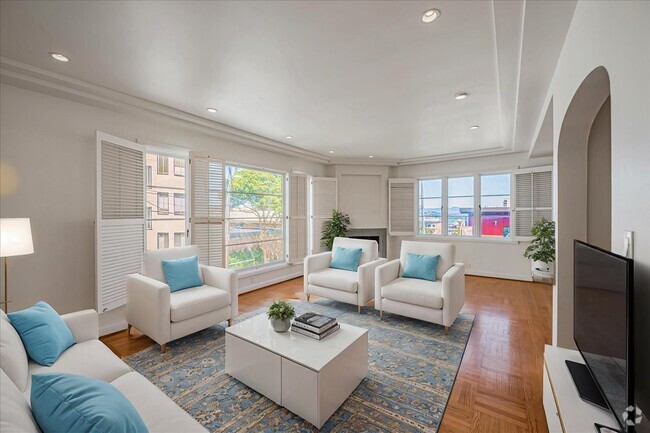
About This Property
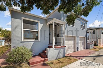
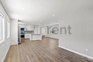
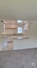
You will love this turn of the century flat located in a Central Berkeley location! Loaded in sunlight with wood flooring, an updated eat-in kitchen and updated bathroom. Fantastic details, gas stove and an in-unit laundry! This is a 4 unit building and is well maintained. Top Floor location, 1 car parking, backyard and front yard are shared. All Tenants share water/trash/sewage fees. Tenant should have good credit and references.
1241 Berkeley Way is a house located in Alameda County and the 94702 ZIP Code. This area is served by the Berkeley Unified attendance zone.
Property Address:
1241 Berkeley Way,
Berkeley,
CA
94702
World famous for its freewheeling lifestyle and free-thinking citizens, Berkeley has never been a better place to live. Tucked along the waterfront, just a couple miles from downtown and less than 15 miles from San Francisco, lies the Northwest Berkeley area.
Students, artists, professionals, and families are all proud to call this affordable and diverse community home. There's always something going on, someone trying something new, and plenty of shops, restaurants and events to explore.
Learn more about living in Northwest BerkeleyBelow are rent ranges for similar nearby apartments
| Beds | Average Size | Lowest | Typical | Premium |
|---|---|---|---|---|
| Studio Studio Studio | 445-448 Sq Ft | $1,700 | $2,353 | $2,873 |
| 1 Bed 1 Bed 1 Bed | 719-720 Sq Ft | $2,295 | $3,077 | $3,735 |
| 2 Beds 2 Beds 2 Beds | 956-969 Sq Ft | $2,095 | $3,929 | $5,378 |
| 3 Beds 3 Beds 3 Beds | 1191 Sq Ft | $2,275 | $4,205 | $5,678 |
| 4 Beds 4 Beds 4 Beds | 1742 Sq Ft | $3,400 | $5,679 | $7,199 |
Education
| Colleges & Universities | Distance | ||
|---|---|---|---|
| Colleges & Universities | Distance | ||
| Drive: | 3 min | 1.2 mi | |
| Drive: | 7 min | 2.1 mi | |
| Drive: | 13 min | 5.3 mi | |
| Drive: | 10 min | 6.0 mi |
1241 Berkeley Way is within 3 minutes or 1.2 miles from Berkeley City College. It is also near UC Berkeley and Samuel Merritt University.
Schools
Public Elementary School
Grades K-5
270 Students
Nearby
3
Out of 10
Public Elementary School
Grades K-5
395 Students
Attendance Zone
9
Out of 10
Public Elementary School
Grades K-5
395 Students
Attendance Zone
7
Out of 10
Public Middle School
Grades 6-8
871 Students
Attendance Zone
7
Out of 10
Public High School
Grades 9-12
3,204 Students
Attendance Zone
8
Out of 10
Private Elementary School
Grades K
20 Students
Nearby
Private Elementary & Middle School
Grades PK-8
55 Students
Nearby
School data provided by
GreatSchools
The GreatSchools Rating helps parents compare schools within a state based on a variety of school quality indicators and provides a helpful picture of how effectively each school serves all of its students. Ratings are on a scale of 1 (below average) to 10 (above average) and can include test scores, college readiness, academic progress, advanced courses, equity, discipline and attendance data. We also advise parents to visit schools, consider other information on school performance and programs, and consider family needs as part of the school selection process.
Transportation options available in Berkeley include North Berkeley Station, located 0.5 mile from 1241 Berkeley Way. 1241 Berkeley Way is near Metro Oakland International, located 16.4 miles or 25 minutes away, and San Francisco International, located 24.0 miles or 37 minutes away.
| Transit / Subway | Distance | ||
|---|---|---|---|
| Transit / Subway | Distance | ||
|
|
Walk: | 9 min | 0.5 mi |
|
|
Drive: | 4 min | 1.3 mi |
|
|
Drive: | 6 min | 2.2 mi |
|
|
Drive: | 7 min | 2.8 mi |
|
|
Drive: | 12 min | 4.3 mi |
| Commuter Rail | Distance | ||
|---|---|---|---|
| Commuter Rail | Distance | ||
|
|
Walk: | 15 min | 0.8 mi |
|
|
Drive: | 7 min | 2.7 mi |
|
|
Drive: | 13 min | 7.9 mi |
| Drive: | 19 min | 11.6 mi | |
| Drive: | 21 min | 12.8 mi |
| Airports | Distance | ||
|---|---|---|---|
| Airports | Distance | ||
|
Metro Oakland International
|
Drive: | 25 min | 16.4 mi |
|
San Francisco International
|
Drive: | 37 min | 24.0 mi |
Time and distance from 1241 Berkeley Way.
| Shopping Centers | Distance | ||
|---|---|---|---|
| Shopping Centers | Distance | ||
| Drive: | 3 min | 1.2 mi | |
| Drive: | 4 min | 1.3 mi | |
| Drive: | 4 min | 1.4 mi |
1241 Berkeley Way has 3 shopping centers within 1.4 miles, which is about a 4-minute drive. The miles and minutes will be for the farthest away property.
| Parks and Recreation | Distance | ||
|---|---|---|---|
| Parks and Recreation | Distance | ||
|
Strawberry Creek Park
|
Walk: | 5 min | 0.3 mi |
|
Cedar-Rose Park
|
Walk: | 9 min | 0.5 mi |
|
McLaughlin Eastshore State Park
|
Drive: | 3 min | 1.1 mi |
|
Habitot Children's Museum
|
Drive: | 4 min | 1.4 mi |
|
Live Oak Park
|
Drive: | 5 min | 1.8 mi |
1241 Berkeley Way has 5 parks within 1.8 miles, including Strawberry Creek Park, Cedar-Rose Park, and McLaughlin Eastshore State Park.
| Hospitals | Distance | ||
|---|---|---|---|
| Hospitals | Distance | ||
| Drive: | 8 min | 2.8 mi | |
| Drive: | 8 min | 3.1 mi | |
| Drive: | 10 min | 5.9 mi |
1241 Berkeley Way has 3 hospitals within 5.9 miles, the nearest is Alta Bates Summit Medical Center - Alta Bates Campus which is 2.8 miles away and a 8 minute drive.
| Military Bases | Distance | ||
|---|---|---|---|
| Military Bases | Distance | ||
| Drive: | 13 min | 5.0 mi | |
| Drive: | 16 min | 7.0 mi |
1241 Berkeley Way is 5.0 miles from Military Reservation, and is convenient to other military bases, including Oakland Army Base.
You May Also Like
Similar Rentals Nearby
-
-
-
-
-
-
 $2,3001 Bed, 1 Bath, 750 sq ftHouse for Rent
 -

-

-
-

What Are Walk Score®, Transit Score®, and Bike Score® Ratings?
Walk Score® measures the walkability of any address. Transit Score® measures access to public transit. Bike Score® measures the bikeability of any address.
What is a Sound Score Rating?
A Sound Score Rating aggregates noise caused by vehicle traffic, airplane traffic and local sources
1241 Berkeley Way
Berkeley, CA 94702