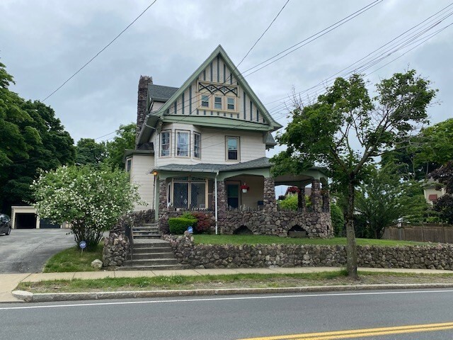
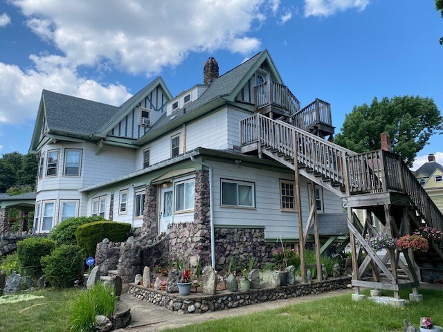
129 Upham St Unit #1
Melrose, MA 02176

-
Monthly Rent
$1,850
-
Bedrooms
1 bd
-
Bathrooms
1 ba
-
Square Feet
600 sq ft
Details

About This Property
1 bed and 1 bath located in Melrose. Easy access to downtown and public transportation!
129 Upham St is an apartment community located in Middlesex County and the 02176 ZIP Code. This area is served by the Melrose attendance zone.
Contact
Fees and Policies
The fees below are based on community-supplied data and may exclude additional fees and utilities.
- Parking
-
Garage--
Details
Utilities Included
-
Water
-
Electricity
Seven miles north of Boston, in the triangle forged by U.S. 1, I-93, and I-95, sits Melrose. Families flock to Melrose because of the serene landscape and proximity to city livelihood. A walkable suburb with plenty of amenities to choose from, Melrose also has a widely used public transportation system that includes access to MBTA Commuter Rail Stations and subway stations.
If you choose to rent in Melrose, you will have your pick of walking trails at parks and ponds to stroll through. Popular choices include Ell Pond and Pine Banks Park. You can play golf at Bellevue Golf Club as well as Mount Hood Memorial Park and Golf Course.
Downtown Melrose, known for its Victorian architecture, is an astute location for the annual Melrose Victorian Fair. A community staple, the Melrose Victorian Fair attracts thousands to the day-long event every year.
Learn more about living in Melrose| Colleges & Universities | Distance | ||
|---|---|---|---|
| Colleges & Universities | Distance | ||
| Drive: | 11 min | 5.8 mi | |
| Drive: | 12 min | 6.3 mi | |
| Drive: | 14 min | 7.3 mi | |
| Drive: | 15 min | 7.6 mi |
Transportation options available in Melrose include Oak Grove Station, located 1.9 miles from 129 Upham St Unit #1. 129 Upham St Unit #1 is near General Edward Lawrence Logan International, located 8.6 miles or 18 minutes away.
| Transit / Subway | Distance | ||
|---|---|---|---|
| Transit / Subway | Distance | ||
|
|
Drive: | 3 min | 1.9 mi |
|
|
Drive: | 5 min | 2.9 mi |
|
|
Drive: | 9 min | 4.4 mi |
| Drive: | 11 min | 5.7 mi | |
|
|
Drive: | 13 min | 6.4 mi |
| Commuter Rail | Distance | ||
|---|---|---|---|
| Commuter Rail | Distance | ||
|
|
Walk: | 14 min | 0.8 mi |
|
|
Walk: | 15 min | 0.8 mi |
|
|
Drive: | 2 min | 1.2 mi |
|
|
Drive: | 4 min | 2.1 mi |
|
|
Drive: | 5 min | 2.9 mi |
| Airports | Distance | ||
|---|---|---|---|
| Airports | Distance | ||
|
General Edward Lawrence Logan International
|
Drive: | 18 min | 8.6 mi |
Time and distance from 129 Upham St Unit #1.
| Shopping Centers | Distance | ||
|---|---|---|---|
| Shopping Centers | Distance | ||
| Walk: | 13 min | 0.7 mi | |
| Drive: | 3 min | 1.5 mi | |
| Drive: | 4 min | 2.0 mi |
| Parks and Recreation | Distance | ||
|---|---|---|---|
| Parks and Recreation | Distance | ||
|
Friends of Middlesex Fells Reservation
|
Walk: | 13 min | 0.7 mi |
|
Middlesex Fells Reservation
|
Drive: | 4 min | 1.9 mi |
|
Walter D. Stone Memorial Zoo
|
Drive: | 5 min | 2.4 mi |
|
Saugus Ironworks National Historic Site
|
Drive: | 7 min | 3.7 mi |
|
Breakheart Reservation
|
Drive: | 12 min | 4.7 mi |
| Hospitals | Distance | ||
|---|---|---|---|
| Hospitals | Distance | ||
| Walk: | 7 min | 0.4 mi | |
| Drive: | 10 min | 4.6 mi | |
| Drive: | 15 min | 7.7 mi |
| Military Bases | Distance | ||
|---|---|---|---|
| Military Bases | Distance | ||
| Drive: | 25 min | 13.5 mi | |
| Drive: | 27 min | 14.6 mi |
129 Upham St Unit #1 Photos
What Are Walk Score®, Transit Score®, and Bike Score® Ratings?
Walk Score® measures the walkability of any address. Transit Score® measures access to public transit. Bike Score® measures the bikeability of any address.
What is a Sound Score Rating?
A Sound Score Rating aggregates noise caused by vehicle traffic, airplane traffic and local sources


