

$4,500 / Month
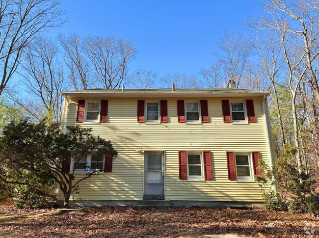
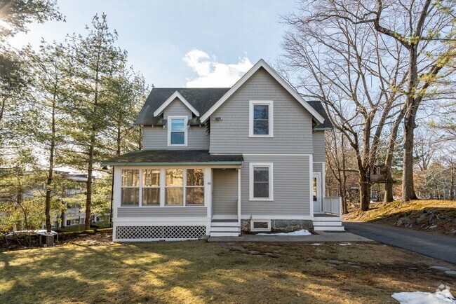
13 Wayside Rd
Westborough, MA 01581
2 Weeks Ago
Favorites
13 Wayside Rd

Favorites
Check Back Soon for Upcoming Availability
| Beds | Baths | Average SF |
|---|---|---|
| 4 Bedrooms 4 Bedrooms 4 Br | 2.5 Baths 2.5 Baths 2.5 Ba | 3,650 SF |
About This Property
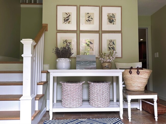
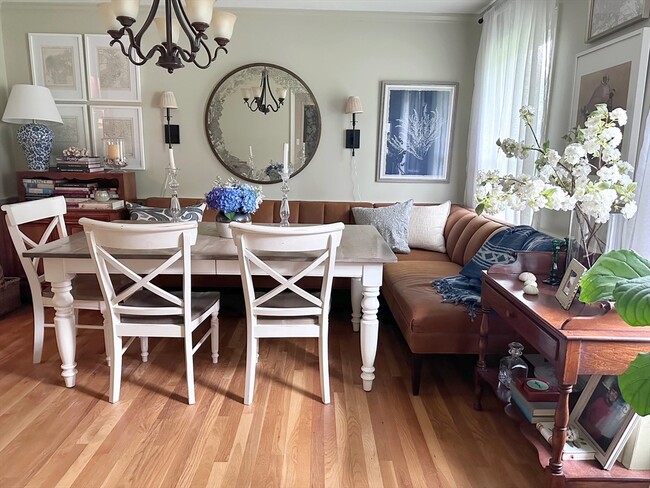
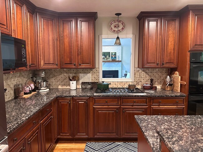
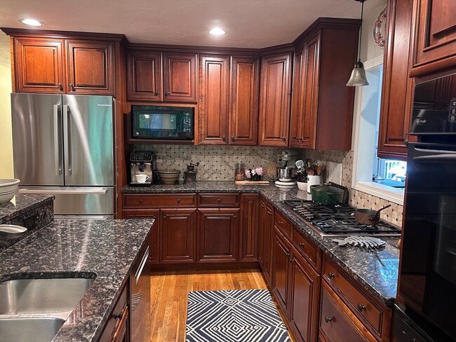
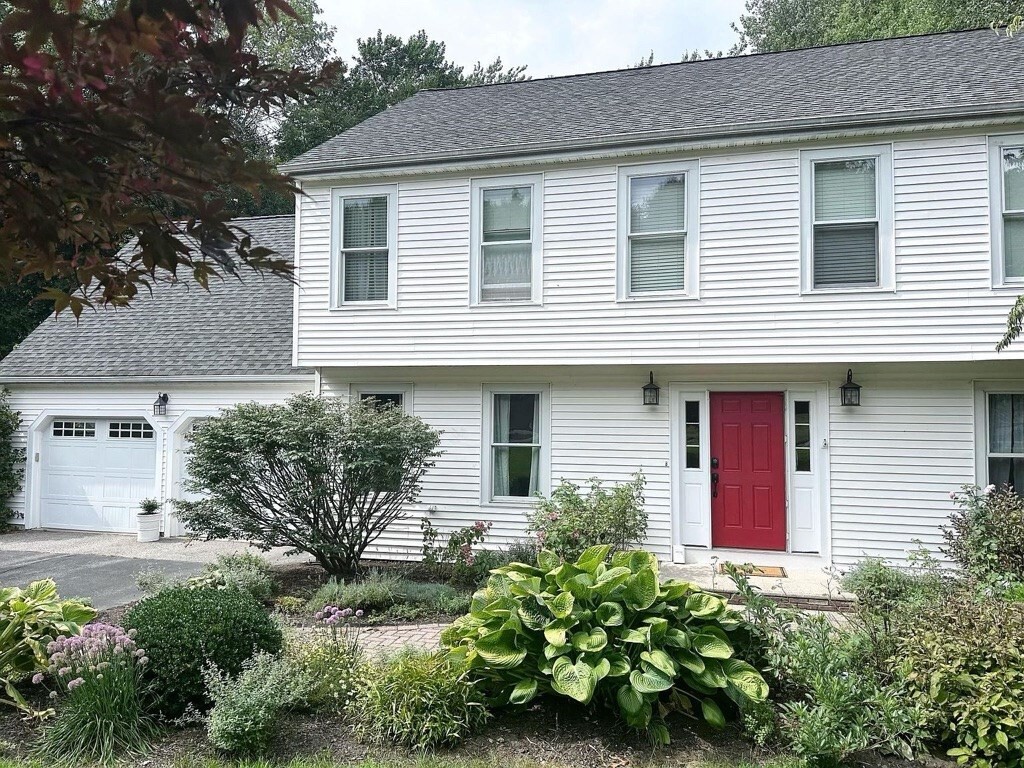
Spacious and well loved family home in a fantastic neighbourhood within the highly ranked Westborough school district. This 4 bedroom 2.5 bath has separate living room,home office,and a cathedral ceiling family room with fireplace and cherry hardwood flooring on the main floor. The home includes a fully finished basement with plenty of space to use as a playroom,home gym,or entertainment/TV room. The second floor hosts three bedrooms,a main bathroom,and a master bedroom with walk-in closet and en suite bath. Enjoy the privacy of the backyard with spacious back deck,perfect for outdoor entertaining,or sit around the fire pit on a cool autumn evening. Conveniently located close to Route 9,I-495,I-90,and the Westborough commuter rail station,and 20 minutes from Worcester and 35 minutes from Boston,this home extends the benefits of town amenities making this an ideal MetroWest location while providing the safety and privacy of a tranquil setting.
13 Wayside Rd is a house located in Worcester County and the 01581 ZIP Code. This area is served by the Westborough attendance zone.
Property Address:
13 Wayside Rd,
Westborough,
MA
01581
Situated just moments east of Worcester is the Route 9 Corridor, a large neighborhood compiled of several communities including Shrewsbury, Westborough, Northborough, and Southborough. Not only is Worcester at residents’ fingertips, but Downtown Boston is less than 40 miles east. The Route 9 Corridor is a commuter’s dream, offering easy city access and entry onto Interstates 290, 495, and 90.
The suburb is dotted with ponds, reservoirs, brooks, and rivers, providing ample outdoor recreation. Renters craving a beach day can bask on the sunny shores of Lake Chauncy Beach. Route 9 Corridor’s Prospect Park allows locals to take their dog for a stroll while Assabet Park gives children ample space to play on the playground. Those looking for winter recreation won’t want to miss the powdery slopes of Ski Ward Ski Area. No matter the season, renters settling in this diverse community can choose from gorgeous apartments ranging in price and amenities.
Learn more about living in Route 9 CorridorBelow are rent ranges for similar nearby apartments
| Beds | Average Size | Lowest | Typical | Premium |
|---|---|---|---|---|
| Studio Studio Studio | 512 Sq Ft | $1,735 | $2,440 | $3,880 |
| 1 Bed 1 Bed 1 Bed | 803-804 Sq Ft | $1,200 | $2,887 | $6,044 |
| 2 Beds 2 Beds 2 Beds | 1168 Sq Ft | $1,550 | $3,592 | $6,713 |
| 3 Beds 3 Beds 3 Beds | 1523 Sq Ft | $2,600 | $4,428 | $12,316 |
| 4 Beds 4 Beds 4 Beds | 2633 Sq Ft | $4,500 | $4,749 | $5,000 |
Education
| Colleges & Universities | Distance | ||
|---|---|---|---|
| Colleges & Universities | Distance | ||
| Drive: | 12 min | 4.5 mi | |
| Drive: | 20 min | 10.6 mi | |
| Drive: | 23 min | 12.4 mi | |
| Drive: | 24 min | 12.7 mi |
13 Wayside Rd is within 12 minutes or 4.5 miles from Tufts University, Grafton. It is also near Stillman College and MCPHS University, Worcester.
Schools


Public Elementary School
Grades PK-3
475 Students
Nearby
Public Elementary School
Grades 4-6
865 Students
Attendance Zone
Public Elementary School
Grades K-3
331 Students
Attendance Zone
Public Middle School
Grades 7-8
590 Students
Attendance Zone
Public High School
Grades 9-12
1,178 Students
Attendance Zone
Private Elementary & Middle School
Grades K-9
467 Students
Nearby
Private Elementary & Middle School
Grades PK-8
183 Students
Nearby
Private Elementary School
Grades PK-K
95 Students
Nearby
Private High School
Grades 9-12
872 Students
Nearby
School data provided by
 The GreatSchools Rating helps parents compare schools within a state based on a variety of school quality indicators and provides a helpful picture of how effectively each school serves all of its students. Ratings are on a scale of 1 (below average) to 10 (above average) and can include test scores, college readiness, academic progress, advanced courses, equity, discipline and attendance data. We also advise parents to visit schools, consider other information on school performance and programs, and consider family needs as part of the school selection process.
View GreatSchools Rating Methodology
View GreatSchools Rating Methodology
Transportation options available in Westborough include Riverside Station, located 24.1 miles from 13 Wayside Rd. 13 Wayside Rd is near Worcester Regional, located 17.4 miles or 34 minutes away, and General Edward Lawrence Logan International, located 37.2 miles or 56 minutes away.
| Transit / Subway | Distance | ||
|---|---|---|---|
| Transit / Subway | Distance | ||
|
|
Drive: | 38 min | 24.1 mi |
|
|
Drive: | 38 min | 24.4 mi |
|
|
Drive: | 40 min | 25.1 mi |
|
|
Drive: | 42 min | 26.7 mi |
|
|
Drive: | 42 min | 26.9 mi |
| Commuter Rail | Distance | ||
|---|---|---|---|
| Commuter Rail | Distance | ||
|
|
Drive: | 11 min | 4.1 mi |
|
|
Drive: | 11 min | 4.6 mi |
|
|
Drive: | 19 min | 9.1 mi |
|
|
Drive: | 26 min | 10.7 mi |
|
|
Drive: | 23 min | 12.1 mi |
| Airports | Distance | ||
|---|---|---|---|
| Airports | Distance | ||
|
Worcester Regional
|
Drive: | 34 min | 17.4 mi |
|
General Edward Lawrence Logan International
|
Drive: | 56 min | 37.2 mi |
Time and distance from 13 Wayside Rd.
| Shopping Centers | Distance | ||
|---|---|---|---|
| Shopping Centers | Distance | ||
| Drive: | 7 min | 2.5 mi | |
| Drive: | 9 min | 3.4 mi | |
| Drive: | 9 min | 3.4 mi |
13 Wayside Rd has 3 shopping centers within 3.4 miles, which is about a 9-minute drive. The miles and minutes will be for the farthest away property.
| Parks and Recreation | Distance | ||
|---|---|---|---|
| Parks and Recreation | Distance | ||
|
Whitehall State Park
|
Drive: | 12 min | 3.5 mi |
|
Upton State Forest
|
Drive: | 9 min | 4.1 mi |
|
Cedar Hill and Sawink Farm Reservation
|
Drive: | 13 min | 5.3 mi |
|
Walkup And Robinson Memorial Reservation
|
Drive: | 12 min | 5.4 mi |
|
Ward Hill Ski Area
|
Drive: | 17 min | 7.3 mi |
13 Wayside Rd has 5 parks within 7.3 miles, including Whitehall State Park, Upton State Forest, and Walkup And Robinson Memorial Reservation.
| Hospitals | Distance | ||
|---|---|---|---|
| Hospitals | Distance | ||
| Drive: | 20 min | 10.2 mi | |
| Drive: | 22 min | 10.7 mi | |
| Drive: | 21 min | 11.3 mi |
13 Wayside Rd has 3 hospitals within 11.3 miles, the nearest is Worcester Recovery Center and Hospital which is 10.2 miles away and a 20 minute drive.
| Military Bases | Distance | ||
|---|---|---|---|
| Military Bases | Distance | ||
| Drive: | 31 min | 17.1 mi |
13 Wayside Rd is 17.1 miles and a 31 minute drive from US Military Reservation.
You May Also Like
Similar Rentals Nearby

What Are Walk Score®, Transit Score®, and Bike Score® Ratings?
Walk Score® measures the walkability of any address. Transit Score® measures access to public transit. Bike Score® measures the bikeability of any address.
What is a Sound Score Rating?
A Sound Score Rating aggregates noise caused by vehicle traffic, airplane traffic and local sources
13 Wayside Rd
Westborough, MA 01581