
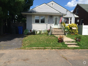
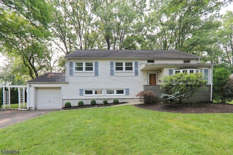
$3,700 / Month
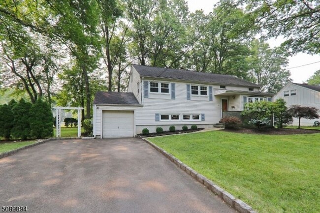
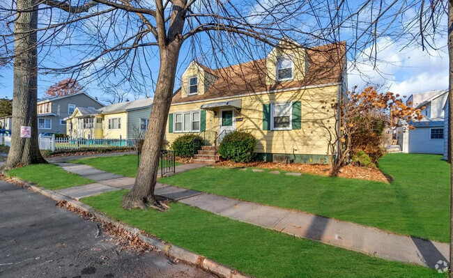
132 Roger Ave
Westfield, NJ 07090
2 Weeks Ago
Favorites
132 Roger Ave

Favorites
Check Back Soon for Upcoming Availability
| Beds | Baths | Average SF |
|---|---|---|
| 4 Bedrooms 4 Bedrooms 4 Br | 2.5 Baths 2.5 Baths 2.5 Ba | — |
About This Property
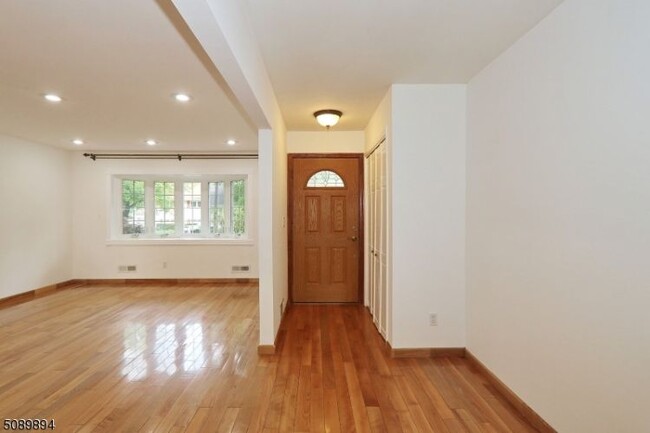
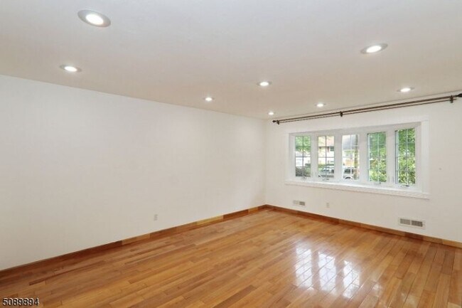
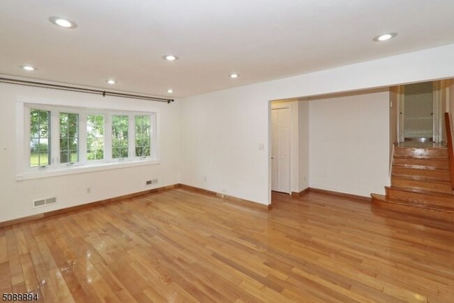
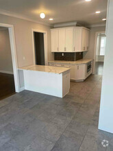
FANTASTIC OPPORTUNITY TO LIVE IN THE DESIRABLE TOWN OF WESTFIELD This Split Level Home is Located on a Large Corner Level Lot on a Tree Lined Street in a Highly Desirable Neighborhood Convenient to Everything: Downtown Westfield, Top Rated Schools, Parks, Houses of Worship, Major Highways and NYC Transportation. This Special Home Boasts: 4 Bedrooms, 2 Full Baths, 1 Half Bath and 1 Car Garage. The Floor Plan is a Perfect Layout for Comfortable Living. Home Features Include: Living Room with Hardwood Floors, Dining Room, Eat In Kitchen with Slider to Deck and Backyard, Family Room, Laundry Room, Storage, One Car Attached Garage and So Much More. Private Backyard is Perfect for Outdoor Relaxing or Entertaining. No Smoking. No Pets. PSEG Worry Free Contract on Appliances.
132 Roger Ave is a house located in Union County and the 07090 ZIP Code. This area is served by the Westfield Public attendance zone.
House Features
Dishwasher
Hardwood Floors
Refrigerator
Tile Floors
- Dishwasher
- Oven
- Refrigerator
- Hardwood Floors
- Tile Floors
- Basement
Fees and Policies
Location
Get Directions
Westfield is a picturesque Union County suburb located about 20 miles southwest of New York City. Westfield offers residents the best of urban and suburban living within its own borders. Residents enjoy a true sense of community, top-notch public schools, and manicured homes in Westfield as well as access to a walkable downtown, dynamic arts scene, and reliable transportation options.
Downtown Westfield is a vibrant combination of national retailers and local shops, award-winning restaurants and cozy cafes, and modern art galleries and historic buildings. Westfield’s cultural scene boasts an orchestra, community theater, movie house, and various events such as the summer jazz series. Nine parks in town provide a host of recreational opportunities in addition to many surrounding parks in the area. Access to NJ Transit and multiple highways makes getting around from Westfield simple.
Learn more about living in Westfield
Amenities
- Dishwasher
- Oven
- Refrigerator
- Hardwood Floors
- Tile Floors
- Basement
Education
| Colleges & Universities | Distance | ||
|---|---|---|---|
| Colleges & Universities | Distance | ||
| Drive: | 11 min | 2.9 mi | |
| Drive: | 17 min | 6.9 mi | |
| Drive: | 16 min | 8.1 mi | |
| Drive: | 16 min | 8.9 mi |
132 Roger Ave is within 11 minutes or 2.9 miles from Union County College, Cranford. It is also near Kean University and Union Co. Coll., Plainfield.
Schools


Public Elementary School
Grades PK-2
294 Students
Nearby
Public Elementary School
Grades 1-5
466 Students
Attendance Zone
Public Middle School
Grades 6-8
781 Students
Attendance Zone
Public High School
Grades 9-12
1,818 Students
Attendance Zone
Private Elementary & Middle School
Grades 1-8
90 Students
Nearby
Private Elementary & Middle School
Grades PK-8
234 Students
Nearby
Private Elementary School
Grades PK-4
124 Students
Nearby
Private Elementary School
Grades PK-1
Nearby
School data provided by
 The GreatSchools Rating helps parents compare schools within a state based on a variety of school quality indicators and provides a helpful picture of how effectively each school serves all of its students. Ratings are on a scale of 1 (below average) to 10 (above average) and can include test scores, college readiness, academic progress, advanced courses, equity, discipline and attendance data. We also advise parents to visit schools, consider other information on school performance and programs, and consider family needs as part of the school selection process.
View GreatSchools Rating Methodology
View GreatSchools Rating Methodology
Transportation options available in Westfield include Warren Street, located 12.8 miles from 132 Roger Ave. 132 Roger Ave is near Newark Liberty International, located 14.5 miles or 20 minutes away, and Laguardia, located 33.7 miles or 55 minutes away.
| Transit / Subway | Distance | ||
|---|---|---|---|
| Transit / Subway | Distance | ||
|
|
Drive: | 20 min | 12.8 mi |
|
|
Drive: | 20 min | 12.8 mi |
|
|
Drive: | 20 min | 13.0 mi |
|
|
Drive: | 20 min | 13.3 mi |
| Drive: | 25 min | 13.9 mi |
| Commuter Rail | Distance | ||
|---|---|---|---|
| Commuter Rail | Distance | ||
|
|
Drive: | 6 min | 1.6 mi |
|
|
Drive: | 5 min | 1.7 mi |
|
|
Drive: | 5 min | 1.8 mi |
|
|
Drive: | 8 min | 3.7 mi |
|
|
Drive: | 11 min | 3.9 mi |
| Airports | Distance | ||
|---|---|---|---|
| Airports | Distance | ||
|
Newark Liberty International
|
Drive: | 20 min | 14.5 mi |
|
Laguardia
|
Drive: | 55 min | 33.7 mi |
Time and distance from 132 Roger Ave.
| Shopping Centers | Distance | ||
|---|---|---|---|
| Shopping Centers | Distance | ||
| Walk: | 17 min | 0.9 mi | |
| Drive: | 3 min | 1.1 mi | |
| Drive: | 5 min | 1.6 mi |
132 Roger Ave has 3 shopping centers within 1.6 miles, which is about a 5-minute walk. The miles and minutes will be for the farthest away property.
| Parks and Recreation | Distance | ||
|---|---|---|---|
| Parks and Recreation | Distance | ||
|
William Miller Sperry Observatory
|
Drive: | 10 min | 3.0 mi |
|
Trailside Museum Watchung Reservation
|
Drive: | 13 min | 4.8 mi |
|
Hawk Rise Sanctuary
|
Drive: | 12 min | 5.0 mi |
|
Liberty State Park
|
Drive: | 15 min | 6.8 mi |
|
Merrill Park
|
Drive: | 13 min | 7.0 mi |
132 Roger Ave has 5 parks within 7.0 miles, including William Miller Sperry Observatory, Trailside Museum Watchung Reservation, and Hawk Rise Sanctuary.
| Hospitals | Distance | ||
|---|---|---|---|
| Hospitals | Distance | ||
| Drive: | 7 min | 2.7 mi | |
| Drive: | 17 min | 7.2 mi | |
| Drive: | 19 min | 7.9 mi |
132 Roger Ave has 3 hospitals within 7.9 miles, the nearest is Robert Wood Johnson University Hospital at Rahway which is 2.7 miles away and a 7 minute drive.
| Military Bases | Distance | ||
|---|---|---|---|
| Military Bases | Distance | ||
| Drive: | 9 min | 2.4 mi | |
| Drive: | 9 min | 3.8 mi | |
| Drive: | 26 min | 18.3 mi |
132 Roger Ave has 3 military bases within 18.3 miles, the nearest is Tamdques Reservation which is 2.4 miles away and a 9 minute drive.
You May Also Like
Similar Rentals Nearby
What Are Walk Score®, Transit Score®, and Bike Score® Ratings?
Walk Score® measures the walkability of any address. Transit Score® measures access to public transit. Bike Score® measures the bikeability of any address.
What is a Sound Score Rating?
A Sound Score Rating aggregates noise caused by vehicle traffic, airplane traffic and local sources
132 Roger Ave
Westfield, NJ 07090