
$3,590 / Month
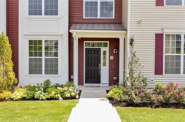
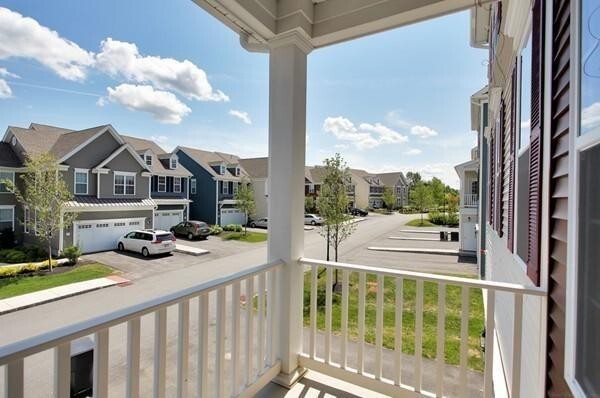
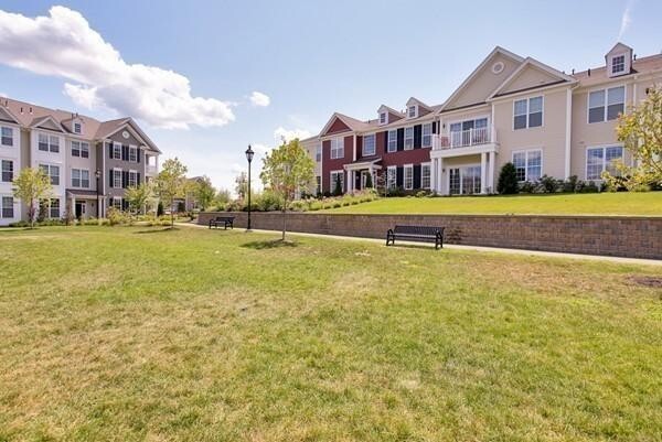
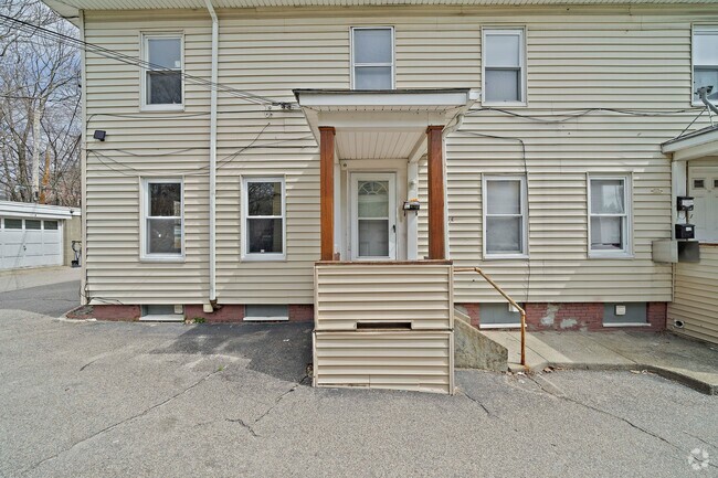
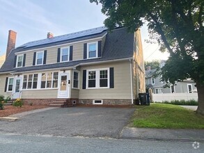
14 Corning Fairbanks Way
Westborough, MA 01581
2 Weeks Ago
Favorites
14 Corning Fairbanks Way

Favorites
Check Back Soon for Upcoming Availability
| Beds | Baths | Average SF |
|---|---|---|
| 3 Bedrooms 3 Bedrooms 3 Br | 2.5 Baths 2.5 Baths 2.5 Ba | 2,000 SF |
About This Property
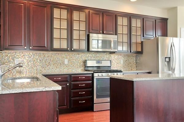
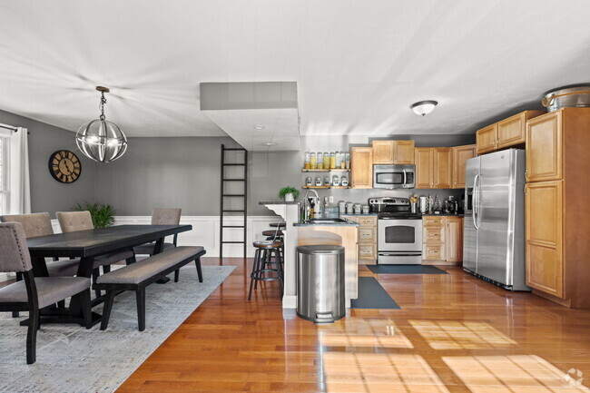
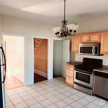
Great opportunity to RENT this beautiful 3 Bed 2.5 bath townhouse in Westborough Village by Toll Brothers. Gorgeous Barrett model with updated kitchen with granite countertops,breakfast bar,glass cabinets,stainless steel appliances and island. Master suite offers a grand double door entry,cathedral ceiling,large walk in closet and bath with whirpool tub and upgraded shower/double vanity. Open floor plan first floor room can be used as study/office area. Conveniently located to Rt. 9,495,shopping,restaurants and commuter rail. First and last month rent with one month security deposit is required prior to occupancy. Showings by appointment only.
14 Corning Fairbanks Way is a townhome located in Worcester County and the 01581 ZIP Code. This area is served by the Westborough attendance zone.
Location
Get Directions
Situated just moments east of Worcester is the Route 9 Corridor, a large neighborhood compiled of several communities including Shrewsbury, Westborough, Northborough, and Southborough. Not only is Worcester at residents’ fingertips, but Downtown Boston is less than 40 miles east. The Route 9 Corridor is a commuter’s dream, offering easy city access and entry onto Interstates 290, 495, and 90.
The suburb is dotted with ponds, reservoirs, brooks, and rivers, providing ample outdoor recreation. Renters craving a beach day can bask on the sunny shores of Lake Chauncy Beach. Route 9 Corridor’s Prospect Park allows locals to take their dog for a stroll while Assabet Park gives children ample space to play on the playground. Those looking for winter recreation won’t want to miss the powdery slopes of Ski Ward Ski Area. No matter the season, renters settling in this diverse community can choose from gorgeous apartments ranging in price and amenities.
Learn more about living in Route 9 CorridorBelow are rent ranges for similar nearby apartments
| Beds | Average Size | Lowest | Typical | Premium |
|---|---|---|---|---|
| Studio Studio Studio | 506 Sq Ft | $1,857 | $2,464 | $4,110 |
| 1 Bed 1 Bed 1 Bed | 798-799 Sq Ft | $1,200 | $2,931 | $7,150 |
| 2 Beds 2 Beds 2 Beds | 1152-1153 Sq Ft | $1,975 | $3,656 | $6,805 |
| 3 Beds 3 Beds 3 Beds | 1461 Sq Ft | $2,200 | $4,755 | $10,802 |
| 4 Beds 4 Beds 4 Beds | 1973 Sq Ft | $3,075 | $4,269 | $5,000 |
Education
| Colleges & Universities | Distance | ||
|---|---|---|---|
| Colleges & Universities | Distance | ||
| Drive: | 8 min | 2.9 mi | |
| Drive: | 14 min | 6.4 mi | |
| Drive: | 17 min | 8.3 mi | |
| Drive: | 17 min | 8.6 mi |
14 Corning Fairbanks Way is within 8 minutes or 2.9 miles from Tufts University, Grafton. It is also near Stillman College and Worcester Polytechnic Inst..
Schools


Public Elementary School
Grades PK-3
475 Students
Nearby
Public Elementary School
Grades K-3
391 Students
Nearby
Public Elementary School
Grades 4-6
865 Students
Nearby
Public Middle School
Grades 7-8
590 Students
Nearby
Public High School
Grades 9-12
1,178 Students
Attendance Zone
Private Elementary & Middle School
Grades PK-8
183 Students
Nearby
Private High School
Grades 9-12
872 Students
Nearby
School data provided by
 The GreatSchools Rating helps parents compare schools within a state based on a variety of school quality indicators and provides a helpful picture of how effectively each school serves all of its students. Ratings are on a scale of 1 (below average) to 10 (above average) and can include test scores, college readiness, academic progress, advanced courses, equity, discipline and attendance data. We also advise parents to visit schools, consider other information on school performance and programs, and consider family needs as part of the school selection process.
View GreatSchools Rating Methodology
View GreatSchools Rating Methodology
Transportation options available in Westborough include Riverside Station, located 25.3 miles from 14 Corning Fairbanks Way. 14 Corning Fairbanks Way is near Worcester Regional, located 13.2 miles or 27 minutes away, and General Edward Lawrence Logan International, located 38.4 miles or 56 minutes away.
| Transit / Subway | Distance | ||
|---|---|---|---|
| Transit / Subway | Distance | ||
|
|
Drive: | 38 min | 25.3 mi |
|
|
Drive: | 38 min | 25.6 mi |
|
|
Drive: | 39 min | 26.3 mi |
|
|
Drive: | 42 min | 27.9 mi |
|
|
Drive: | 42 min | 28.1 mi |
| Commuter Rail | Distance | ||
|---|---|---|---|
| Commuter Rail | Distance | ||
|
|
Walk: | 16 min | 0.9 mi |
|
|
Drive: | 7 min | 3.0 mi |
|
|
Drive: | 17 min | 7.9 mi |
|
|
Drive: | 16 min | 8.0 mi |
|
|
Drive: | 19 min | 10.2 mi |
| Airports | Distance | ||
|---|---|---|---|
| Airports | Distance | ||
|
Worcester Regional
|
Drive: | 27 min | 13.2 mi |
|
General Edward Lawrence Logan International
|
Drive: | 56 min | 38.4 mi |
Time and distance from 14 Corning Fairbanks Way.
| Shopping Centers | Distance | ||
|---|---|---|---|
| Shopping Centers | Distance | ||
| Drive: | 6 min | 1.6 mi | |
| Drive: | 5 min | 2.0 mi | |
| Drive: | 7 min | 2.3 mi |
14 Corning Fairbanks Way has 3 shopping centers within 2.3 miles, which is about a 7-minute drive. The miles and minutes will be for the farthest away property.
| Parks and Recreation | Distance | ||
|---|---|---|---|
| Parks and Recreation | Distance | ||
|
Ward Hill Ski Area
|
Drive: | 10 min | 4.6 mi |
|
Quinsigamond State Park
|
Drive: | 13 min | 6.3 mi |
|
Walkup And Robinson Memorial Reservation
|
Drive: | 12 min | 6.5 mi |
|
Cedar Hill and Sawink Farm Reservation
|
Drive: | 13 min | 6.6 mi |
|
Whitehall State Park
|
Drive: | 20 min | 7.0 mi |
14 Corning Fairbanks Way has 5 parks within 7.0 miles, including Ward Hill Ski Area, Walkup And Robinson Memorial Reservation, and Cedar Hill and Sawink Farm Reservation.
| Hospitals | Distance | ||
|---|---|---|---|
| Hospitals | Distance | ||
| Drive: | 13 min | 6.1 mi | |
| Drive: | 13 min | 6.4 mi | |
| Drive: | 17 min | 8.3 mi |
14 Corning Fairbanks Way has 3 hospitals within 8.3 miles, the nearest is Worcester Recovery Center and Hospital which is 6.1 miles away and a 13 minute drive.
| Military Bases | Distance | ||
|---|---|---|---|
| Military Bases | Distance | ||
| Drive: | 31 min | 18.2 mi |
14 Corning Fairbanks Way is 18.2 miles and a 31 minute drive from US Military Reservation.
You May Also Like
Similar Rentals Nearby

What Are Walk Score®, Transit Score®, and Bike Score® Ratings?
Walk Score® measures the walkability of any address. Transit Score® measures access to public transit. Bike Score® measures the bikeability of any address.
What is a Sound Score Rating?
A Sound Score Rating aggregates noise caused by vehicle traffic, airplane traffic and local sources
14 Corning Fairbanks Way
Westborough, MA 01581