-
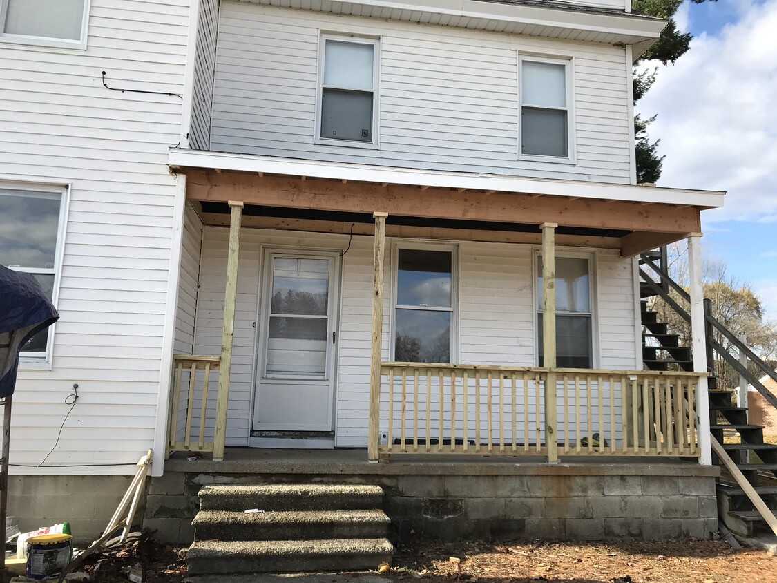
22 Dairy Rd
$850 / Month
149 George Hill Rd Unit 7
Lancaster, MA 01523
2 Weeks Ago
Favorites
149 George Hill Rd Unit 7

Favorites
Check Back Soon for Upcoming Availability
| Beds | Baths | Average SF |
|---|---|---|
| 1 Bedroom 1 Bedroom 1 Br | 1 Bath 1 Bath 1 Ba | 600 SF |
149 George Hill Rd is an apartment community located in Worcester County and the 01523 ZIP Code.
Apartment Features
- Smoke Free
Fees and Policies
The fees below are based on community-supplied data and may exclude additional fees and utilities.
- Parking
-
Surface Lot--
Details
Utilities Included
-
Water
-
Heat
Property Information
-
4 units
Property Address:
149 George Hill Rd,
Lancaster,
MA
01523
Lancaster is a small town that blends sprawling farmland with a few suburban streets. If you travel south along Main Street in this secluded suburb, you’ll find more restaurants and an array of businesses like Michael’s Bridge Diner. Lancaster is adjacent to larger cities, so though it has a tranquil atmosphere, there are more job, dining, shopping, and entertainment opportunities outside of town.
Leominster sits to the west of Lancaster and Clinton sits directly south. The Bolton Flats Wildlife Management Area is to the east of Lancaster, and Interstate 190 is to the west. Check out nearby recreational attractions like the Wachusett Mountain State Reservation including 17 miles of hiking and biking trails and scenic ski slopes, or visit Leominster State Forest for additional hiking and skiing trails, fishing, and mountain climbing.
Learn more about living in Lancaster
Amenities
- Smoke Free
Expenses
Utilities Included
Water, Heat
Included
Education
| Colleges & Universities | Distance | ||
|---|---|---|---|
| Colleges & Universities | Distance | ||
| Drive: | 27 min | 12.4 mi | |
| Drive: | 24 min | 13.4 mi | |
| Drive: | 27 min | 14.4 mi | |
| Drive: | 34 min | 21.3 mi |
149 George Hill Rd Unit 7 is within 27 minutes or 12.4 miles from Quinsigamond Community College. It is also near Fitchburg State University and Stillman College.
Transportation options available in Lancaster include Riverside Station, located 37.0 miles from 149 George Hill Rd Unit 7. 149 George Hill Rd Unit 7 is near Worcester Regional, located 25.5 miles or 40 minutes away.
| Transit / Subway | Distance | ||
|---|---|---|---|
| Transit / Subway | Distance | ||
|
|
Drive: | 50 min | 37.0 mi |
|
|
Drive: | 50 min | 37.4 mi |
|
|
Drive: | 52 min | 38.1 mi |
|
|
Drive: | 54 min | 39.6 mi |
|
|
Drive: | 54 min | 39.9 mi |
| Commuter Rail | Distance | ||
|---|---|---|---|
| Commuter Rail | Distance | ||
|
|
Drive: | 16 min | 8.6 mi |
|
|
Drive: | 20 min | 10.1 mi |
|
|
Drive: | 25 min | 12.4 mi |
|
|
Drive: | 23 min | 12.7 mi |
|
|
Drive: | 25 min | 15.7 mi |
| Airports | Distance | ||
|---|---|---|---|
| Airports | Distance | ||
|
Worcester Regional
|
Drive: | 40 min | 25.5 mi |
Time and distance from 149 George Hill Rd Unit 7.
| Shopping Centers | Distance | ||
|---|---|---|---|
| Shopping Centers | Distance | ||
| Drive: | 3 min | 1.2 mi | |
| Drive: | 5 min | 2.2 mi | |
| Drive: | 11 min | 5.0 mi |
149 George Hill Rd Unit 7 has 3 shopping centers within 5.0 miles, which is about a 11-minute drive. The miles and minutes will be for the farthest away property.
| Parks and Recreation | Distance | ||
|---|---|---|---|
| Parks and Recreation | Distance | ||
|
Mount Pisgah Conservation Area
|
Drive: | 20 min | 8.0 mi |
|
Tower Hill Botanic Garden
|
Drive: | 15 min | 8.0 mi |
|
Oxbow National Wildlife Refuge
|
Drive: | 15 min | 8.1 mi |
|
Mass Audubon's Lincoln Woods Wildlife Sanctuary
|
Drive: | 17 min | 9.0 mi |
|
Felton Conservation Area
|
Drive: | 22 min | 13.7 mi |
149 George Hill Rd Unit 7 has 5 parks within 13.7 miles, including Mount Pisgah Conservation Area, Mass Audubon's Lincoln Woods Wildlife Sanctuary, and Tower Hill Botanic Garden.
| Hospitals | Distance | ||
|---|---|---|---|
| Hospitals | Distance | ||
| Drive: | 18 min | 10.1 mi | |
| Drive: | 21 min | 10.4 mi | |
| Drive: | 22 min | 12.4 mi |
149 George Hill Rd Unit 7 has 3 hospitals within 12.4 miles, the nearest is Healthalliance Hospitals which is 10.1 miles away and a 18 minute drive.
You May Also Like
Similar Rentals Nearby


What Are Walk Score®, Transit Score®, and Bike Score® Ratings?
Walk Score® measures the walkability of any address. Transit Score® measures access to public transit. Bike Score® measures the bikeability of any address.
What is a Sound Score Rating?
A Sound Score Rating aggregates noise caused by vehicle traffic, airplane traffic and local sources

149 George Hill Rd
Lancaster, MA 01523