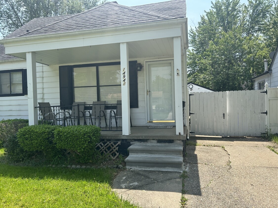
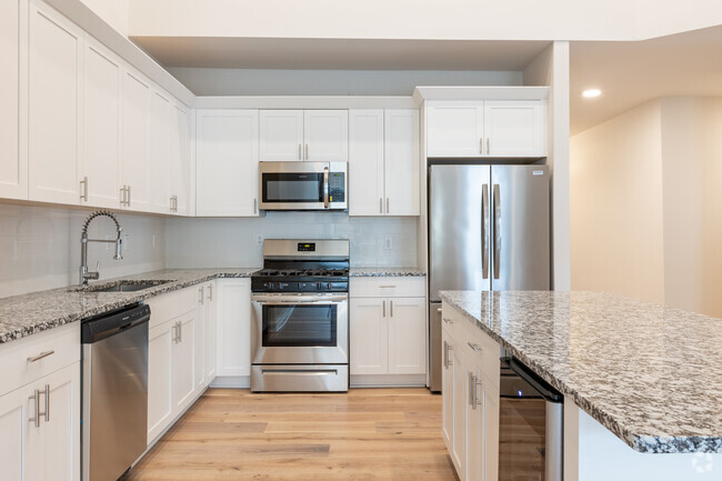
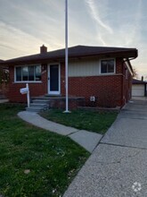
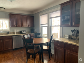
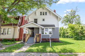
$1,400 / Month
14948 Chesterfield Ave
Warren, MI 48089
Today
Favorites
586-224-2786
-
Bedrooms
3
-
Bathrooms
1
-
Square Feet
--
-
Available
Available May 1
14948 Chesterfield Ave

Favorites
Southeast Warren is located roughly 20 miles north of Detroit, offering a quick commute into the city for work or play. The city of Warren offers a park-like atmosphere, while Southeast Warren’s main streets are lined with casual dining options, shops, and services. Along with easy access to Detroit and plentiful shopping and dining options, Southwest Warren residents enjoy a low cost of living. Apartments and houses available for rent in the area are very affordable, making Southeast Warren a great place for renters on a budget who wish to stay close to Detroit. Although Southeast Warren sits so close to the city, the area still offers a peaceful, family-friendly atmosphere and a close-knit community.
Learn more about living in Southeast Warren
Education
| Colleges & Universities | Distance | ||
|---|---|---|---|
| Colleges & Universities | Distance | ||
| Drive: | 8 min | 2.6 mi | |
| Drive: | 13 min | 6.8 mi | |
| Drive: | 17 min | 7.1 mi | |
| Drive: | 17 min | 11.4 mi |
14948 Chesterfield Ave is within 8 minutes or 2.6 miles from Macomb Community College. It is also near Wayne County C.C., Eastern and Baker Coll. Clinton Township.
Schools


Public Elementary School
Grades 3-5
242 Students
Attendance Zone
Public Elementary School
Grades PK-2
294 Students
Attendance Zone
Charter Elementary & Middle School
Grades PK-7
202 Students
Nearby
Public Middle School
Grades 6-8
464 Students
Attendance Zone
Public High School
Grades 9-12
633 Students
Attendance Zone
Private Elementary & Middle School
Grades K-8
92 Students
Nearby
Private Elementary & Middle School
Grades PK-8
Nearby
Private High School
Grades 9-12
686 Students
Nearby
School data provided by
 The GreatSchools Rating helps parents compare schools within a state based on a variety of school quality indicators and provides a helpful picture of how effectively each school serves all of its students. Ratings are on a scale of 1 (below average) to 10 (above average) and can include test scores, college readiness, academic progress, advanced courses, equity, discipline and attendance data. We also advise parents to visit schools, consider other information on school performance and programs, and consider family needs as part of the school selection process.
View GreatSchools Rating Methodology
View GreatSchools Rating Methodology
Transportation options available in Warren include Amsterdam St - Northbound, located 11.0 miles from 14948 Chesterfield Ave. 14948 Chesterfield Ave is near Detroit Metro Wayne County, located 32.1 miles or 52 minutes away.
| Transit / Subway | Distance | ||
|---|---|---|---|
| Transit / Subway | Distance | ||
| Drive: | 23 min | 11.0 mi | |
| Drive: | 23 min | 11.0 mi | |
| Drive: | 23 min | 11.2 mi | |
| Drive: | 23 min | 11.2 mi | |
| Drive: | 23 min | 11.3 mi |
| Commuter Rail | Distance | ||
|---|---|---|---|
| Commuter Rail | Distance | ||
|
|
Drive: | 23 min | 11.2 mi |
|
|
Drive: | 18 min | 11.8 mi |
|
|
Drive: | 27 min | 16.8 mi |
|
|
Drive: | 39 min | 20.6 mi |
| Airports | Distance | ||
|---|---|---|---|
| Airports | Distance | ||
|
Detroit Metro Wayne County
|
Drive: | 52 min | 32.1 mi |
Time and distance from 14948 Chesterfield Ave.
| Shopping Centers | Distance | ||
|---|---|---|---|
| Shopping Centers | Distance | ||
| Walk: | 2 min | 0.2 mi | |
| Walk: | 17 min | 0.9 mi | |
| Drive: | 3 min | 1.5 mi |
14948 Chesterfield Ave has 3 shopping centers within 1.5 miles, which is about a 3-minute walk. The miles and minutes will be for the farthest away property.
| Parks and Recreation | Distance | ||
|---|---|---|---|
| Parks and Recreation | Distance | ||
|
Freedom Hill County Park
|
Drive: | 15 min | 8.2 mi |
|
Michigan Transit Museum
|
Drive: | 17 min | 9.8 mi |
|
Red Oaks Nature Center and County Park
|
Drive: | 17 min | 10.0 mi |
|
Palmer Park
|
Drive: | 23 min | 11.0 mi |
|
Belle Isle Nature Zoo
|
Drive: | 16 min | 11.2 mi |
14948 Chesterfield Ave has 5 parks within 11.2 miles, including Freedom Hill County Park, Red Oaks Nature Center and County Park, and Michigan Transit Museum.
| Hospitals | Distance | ||
|---|---|---|---|
| Hospitals | Distance | ||
| Drive: | 7 min | 3.0 mi | |
| Drive: | 8 min | 4.0 mi | |
| Drive: | 14 min | 7.9 mi |
14948 Chesterfield Ave has 3 hospitals within 7.9 miles, the nearest is BCA StoneCrest Center which is 3.0 miles away and a 7 minute drive.
You May Also Like
Similar Rentals Nearby
What Are Walk Score®, Transit Score®, and Bike Score® Ratings?
Walk Score® measures the walkability of any address. Transit Score® measures access to public transit. Bike Score® measures the bikeability of any address.
What is a Sound Score Rating?
A Sound Score Rating aggregates noise caused by vehicle traffic, airplane traffic and local sources

14948 Chesterfield Ave
Warren, MI 48089