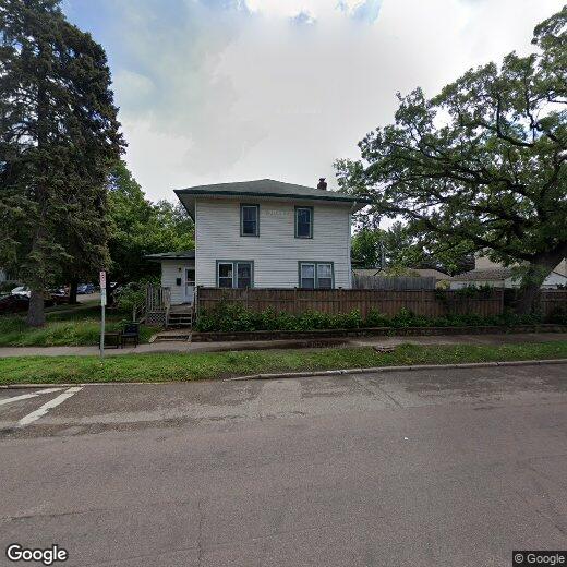
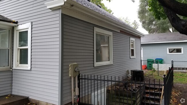
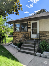
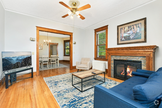
1576 Sargent Ave
1576 Sargent Ave
Saint Paul, MN 55105
2 Weeks Ago
Favorites
1576 Sargent Ave

Favorites
Check Back Soon for Upcoming Availability
Location
Get Directions
Macalester-Groveland, sometimes shortened to Mac-Grove, stretches from the eastern banks of the Mississippi River to Summit Hill. Mac-Grove is a largely residential neighborhood, touting an array of apartments and single-family homes available for rent.
The neighborhood contains the picturesque Summit Avenue Historic District, which boasts an impressive collection of Victorian-era homes between dense canopies of lush trees. One block south of Summit Avenue is the vibrant Grand Avenue, which is teeming with specialty shops, independent coffeehouses, and eclectic eateries.
Mac-Grove is famously convenient to multiple private colleges, including the University of Saint Thomas, Saint Catherine University, and Macalester College, making the neighborhood a top choice for many students, faculty, and staff. The community celebrates the start of the summer season every year with the annual Grand Old Day Festival.
Learn more about living in Macalester-GrovelandBelow are rent ranges for similar nearby apartments
Education
| Colleges & Universities | Distance | ||
|---|---|---|---|
| Colleges & Universities | Distance | ||
| Walk: | 5 min | 0.3 mi | |
| Drive: | 2 min | 1.5 mi | |
| Drive: | 5 min | 1.7 mi | |
| Drive: | 4 min | 1.7 mi |
1576 Sargent Ave is within 5 minutes or 0.3 mile from Macalester College. It is also near Concordia Univ.-Saint Paul and St. Catherine University.
Transportation options available in Saint Paul include Snelling Ave Station, located 1.5 miles from 1576 Sargent Ave. 1576 Sargent Ave is near Minneapolis-St Paul International/Wold-Chamberlain, located 6.3 miles or 13 minutes away.
| Transit / Subway | Distance | ||
|---|---|---|---|
| Transit / Subway | Distance | ||
| Drive: | 2 min | 1.5 mi | |
| Drive: | 3 min | 1.9 mi | |
| Drive: | 3 min | 2.0 mi | |
| Drive: | 4 min | 2.4 mi | |
| Drive: | 5 min | 2.9 mi |
| Commuter Rail | Distance | ||
|---|---|---|---|
| Commuter Rail | Distance | ||
|
|
Drive: | 9 min | 5.5 mi |
|
|
Drive: | 15 min | 7.7 mi |
|
|
Drive: | 23 min | 16.3 mi |
|
|
Drive: | 33 min | 25.1 mi |
|
|
Drive: | 34 min | 26.8 mi |
| Airports | Distance | ||
|---|---|---|---|
| Airports | Distance | ||
|
Minneapolis-St Paul International/Wold-Chamberlain
|
Drive: | 13 min | 6.3 mi |
Time and distance from 1576 Sargent Ave.
| Shopping Centers | Distance | ||
|---|---|---|---|
| Shopping Centers | Distance | ||
| Walk: | 6 min | 0.3 mi | |
| Drive: | 3 min | 1.6 mi | |
| Drive: | 3 min | 1.8 mi |
1576 Sargent Ave has 3 shopping centers within 1.8 miles, which is about a 3-minute walk. The miles and minutes will be for the farthest away property.
| Parks and Recreation | Distance | ||
|---|---|---|---|
| Parks and Recreation | Distance | ||
|
Macalester College Observatory
|
Walk: | 3 min | 0.2 mi |
|
Highland Park and Golf Course
|
Drive: | 5 min | 2.5 mi |
|
Newell Park
|
Drive: | 6 min | 2.8 mi |
|
Hidden Falls Park
|
Drive: | 9 min | 3.6 mi |
|
Hiawatha School Park
|
Drive: | 10 min | 4.1 mi |
1576 Sargent Ave has 5 parks within 4.1 miles, including Macalester College Observatory, Highland Park and Golf Course, and Newell Park.
| Hospitals | Distance | ||
|---|---|---|---|
| Hospitals | Distance | ||
| Drive: | 6 min | 3.3 mi | |
| Drive: | 7 min | 4.5 mi | |
| Drive: | 8 min | 5.0 mi |
1576 Sargent Ave has 3 hospitals within 5.0 miles, the nearest is Allina United Hospital which is 3.3 miles away and a 6 minute drive.
| Military Bases | Distance | ||
|---|---|---|---|
| Military Bases | Distance | ||
| Drive: | 12 min | 5.0 mi |
1576 Sargent Ave is 5.0 miles and a 12 minute drive from Fort Snelling Military Reservation.
You May Also Like
Similar Rentals Nearby

What Are Walk Score®, Transit Score®, and Bike Score® Ratings?
Walk Score® measures the walkability of any address. Transit Score® measures access to public transit. Bike Score® measures the bikeability of any address.
What is a Sound Score Rating?
A Sound Score Rating aggregates noise caused by vehicle traffic, airplane traffic and local sources