

$3,000 / Month
16 Taber St Unit 602
Boston, MA 02119
Today
Favorites
617-216-1493
-
Bedrooms
1
-
Bathrooms
1
-
Square Feet
741 sq ft
-
Available
Available Now
Highlights
- Medical Services
- Property is near public transit
- Jogging Path
- Intercom
- Cooling Available
- Park
16 Taber St Unit 602

Favorites
About This Home
$3,000 deposit,
Available Now
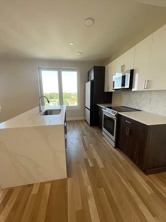
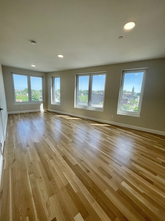
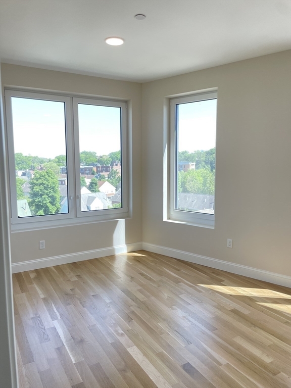
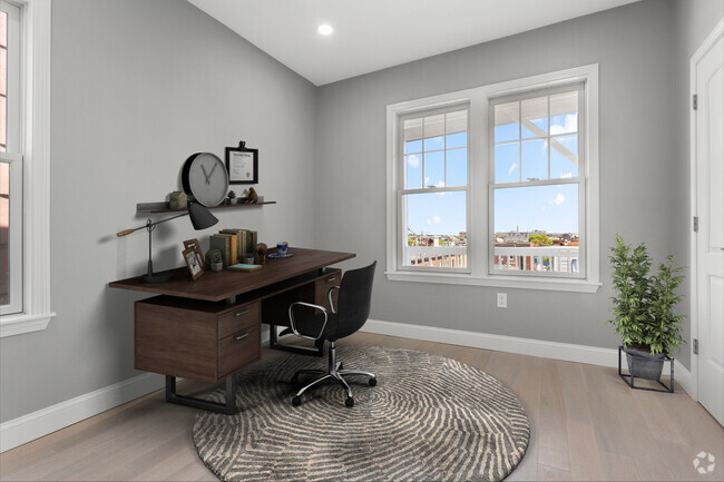
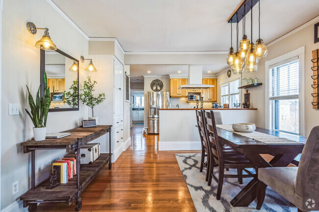
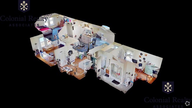
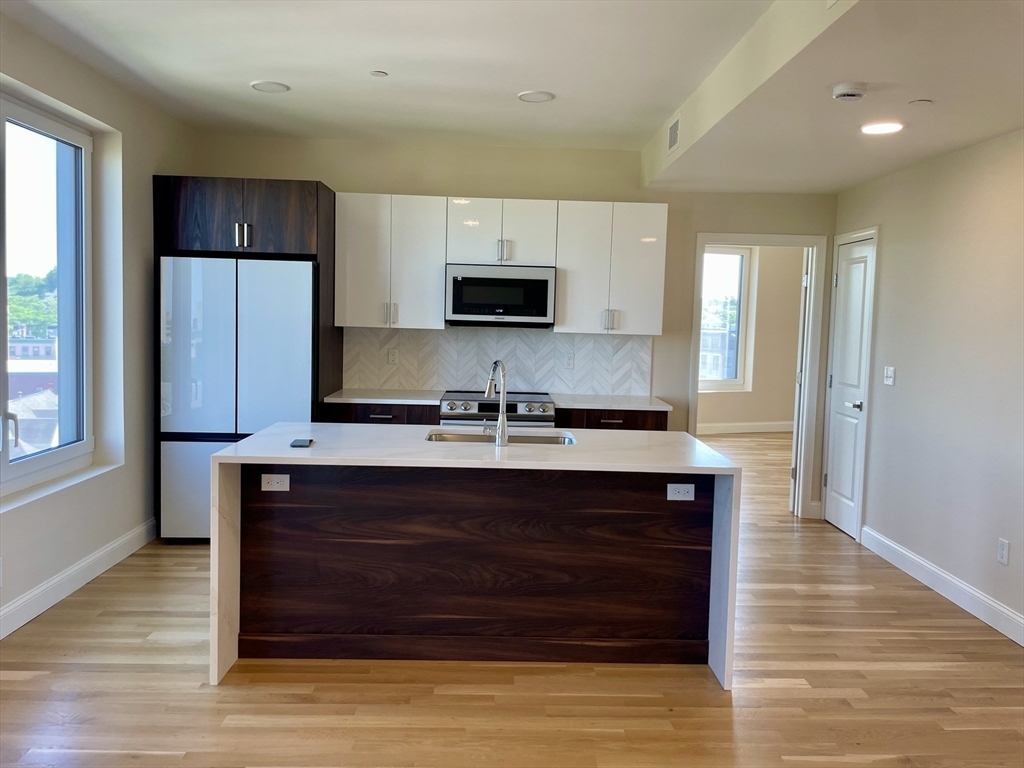
PENTHOUSE LEVEL- Corner oversized 1-bedroom unit easily accessible to Nubian Square Bus Station,Hospitals Medical schools,Boston Public Library,restaurants,banks,Parks and grocery shopping. This centrally-located and newly developed condominium is equipped with a residential lobby and separate lounge,bicycle-storage,elevator and professional off-site management. You'll find unobstructed views over Roxbury from the East and South facing windows of this penthouse unit. An open-concept living area is decorated with a 2-tone kitchen with island and waterfall countertops. Oak-hardwood flooring stretches across the home and triple-pane windows wrap the suite to provide a bright & quiet environment. This condo's oversized bedroom affords flex-space for an in-home office,additional clothing storage & more. Ready to move-in August 1st 2025. Heat and Hot water Included.
16 Taber St is a condo located in Suffolk County and the 02119 ZIP Code.
* Price shown is base rent and may not include non-optional fees and utilities.
Price, availability, fees, and any applicable rent special are subject to change without notice.
* Square footage definitions vary. Displayed square footage is approximate.
Home Details
Home Type
Condominium
Year Built
Built in 2024
Accessible Home Design
Entry on the 6th floor
Bedrooms and Bathrooms
1 Full Bathroom
1 Bedroom
Home Security
Intercom
Interior Spaces
741 Sq Ft Home
Kitchen
ENERGY STAR Qualified Dishwasher
ENERGY STAR Qualified Refrigerator
Range
Oven
Microwave
Disposal
Laundry
ENERGY STAR Qualified Dryer
Laundry in unit
ENERGY STAR Qualified Washer
Listing and Financial Details
Security Deposit $3,000
Property Available on 8/1/25
12 Month Lease Term
Rent includes heat, hot water, water, sewer, snow removal, gardener
Location
Property is near public transit
Property is near schools
Utilities
Cooling Available
Central Heating
Hydro-Air Heating System
Community Details
Amenities
Medical Services
Shops
Coin Laundry
Overview
Property has a Home Owners Association
Pet Policy
Call for details about the types of pets allowed
Recreation
Jogging Path
Park
Bike Trail
Fees and Policies
The fees below are based on community-supplied data and may exclude additional fees and utilities.
Pet policies are negotiable.
Contact
- Listed by The Shahani Group | Compass
- Phone Number
-
Source
 MLS Property Information Network
The property listing data and information set forth herein were provided to MLS Property Information Network, Inc. from third party sources, including sellers, lessors and public records, and were compiled by MLS Property Information Network, Inc. The property listing data and information are for the personal, non-commercial use of consumers having a good faith interest in purchasing or leasing listed properties of the type displayed to them and may not be used for any purpose other than to identify prospective properties which such consumers may have a good faith interest in purchasing or leasing. MLS Property Information Network, Inc. and its subscribers disclaim any and all representations and warranties as to the accuracy of the property listing data and information set forth herein. All properties are subject to prior sale, change or withdrawal. Copyright © 2025 MLS Property Information Network, Inc. All rights reserved.
Location
Get Directions
Amenities
- Disposal
- Microwave
- Range
- Elevator
Situated between the South End and Dudley Square, Lower Roxbury is a predominantly residential neighborhood brimming with apartments and town houses available for rent. Residents enjoy a walkable urban environment filled with diverse historical architecture.
Warren Street and Washington Street are the neighborhood’s main commercial thoroughfares, touting rows of specialty shops, markets, and eateries in historic buildings. Northeastern University, Wentworth Institute of Technology, and Massachusetts College of Art and Design are all just northwest of Lower Roxbury, offering the community a bevy of cultural and educational amenities. Getting around from Lower Roxbury is easy with access to multiple T stops on the Orange Line.
Learn more about living in Lower Roxbury
Education
| Colleges & Universities | Distance | ||
|---|---|---|---|
| Colleges & Universities | Distance | ||
| Drive: | 2 min | 1.2 mi | |
| Drive: | 2 min | 1.4 mi | |
| Drive: | 4 min | 1.4 mi | |
| Drive: | 3 min | 1.5 mi |
16 Taber St Unit 602 is within 4 minutes or 1.4 miles from Northeastern University. It is also near Wentworth Inst. of Technology and MassArt.
Transportation options available in Boston include Roxbury Crossing Station, located 0.8 mile from 16 Taber St Unit 602. 16 Taber St Unit 602 is near General Edward Lawrence Logan International, located 5.8 miles or 11 minutes away.
| Transit / Subway | Distance | ||
|---|---|---|---|
| Transit / Subway | Distance | ||
|
|
Walk: | 15 min | 0.8 mi |
|
|
Drive: | 2 min | 1.2 mi |
|
|
Drive: | 3 min | 1.4 mi |
|
|
Drive: | 3 min | 1.4 mi |
|
|
Drive: | 3 min | 1.5 mi |
| Commuter Rail | Distance | ||
|---|---|---|---|
| Commuter Rail | Distance | ||
| Drive: | 3 min | 1.3 mi | |
|
|
Drive: | 3 min | 1.5 mi |
|
|
Drive: | 3 min | 1.5 mi |
|
|
Drive: | 7 min | 2.0 mi |
|
|
Drive: | 9 min | 4.8 mi |
| Airports | Distance | ||
|---|---|---|---|
| Airports | Distance | ||
|
General Edward Lawrence Logan International
|
Drive: | 11 min | 5.8 mi |
Time and distance from 16 Taber St Unit 602.
| Shopping Centers | Distance | ||
|---|---|---|---|
| Shopping Centers | Distance | ||
| Walk: | 15 min | 0.8 mi | |
| Drive: | 4 min | 1.7 mi | |
| Drive: | 11 min | 6.0 mi |
16 Taber St Unit 602 has 3 shopping centers within 6.0 miles, which is about a 11-minute walk. The miles and minutes will be for the farthest away property.
| Parks and Recreation | Distance | ||
|---|---|---|---|
| Parks and Recreation | Distance | ||
|
Roxbury Heritage State Park
|
Walk: | 9 min | 0.5 mi |
|
Lower Neponset River Trail
|
Drive: | 4 min | 2.0 mi |
|
Franklin Park Zoo
|
Drive: | 4 min | 2.2 mi |
|
Boston Public Garden
|
Drive: | 5 min | 2.3 mi |
|
Charles River Reservation
|
Drive: | 5 min | 2.6 mi |
16 Taber St Unit 602 has 5 parks within 2.6 miles, including Roxbury Heritage State Park, Lower Neponset River Trail, and Franklin Park Zoo.
| Hospitals | Distance | ||
|---|---|---|---|
| Hospitals | Distance | ||
| Walk: | 10 min | 0.6 mi | |
| Walk: | 16 min | 0.9 mi | |
| Drive: | 3 min | 1.5 mi |
16 Taber St Unit 602 has 3 hospitals within 1.5 miles, the nearest is Boston Medical Center which is 0.6 mile away and a 10 minute walk.
| Military Bases | Distance | ||
|---|---|---|---|
| Military Bases | Distance | ||
| Drive: | 31 min | 16.7 mi |
16 Taber St Unit 602 is 16.7 miles and a 31 minute drive from Hanscom Air Force Base.
You May Also Like
Similar Rentals Nearby
What Are Walk Score®, Transit Score®, and Bike Score® Ratings?
Walk Score® measures the walkability of any address. Transit Score® measures access to public transit. Bike Score® measures the bikeability of any address.
What is a Sound Score Rating?
A Sound Score Rating aggregates noise caused by vehicle traffic, airplane traffic and local sources
16 Taber St
Boston, MA 02119