
$25,000 / Month
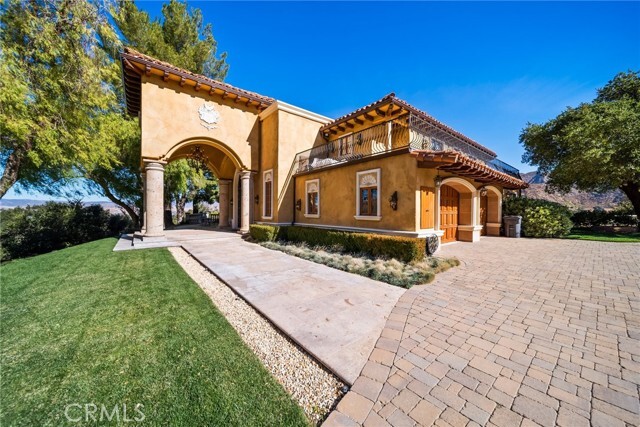
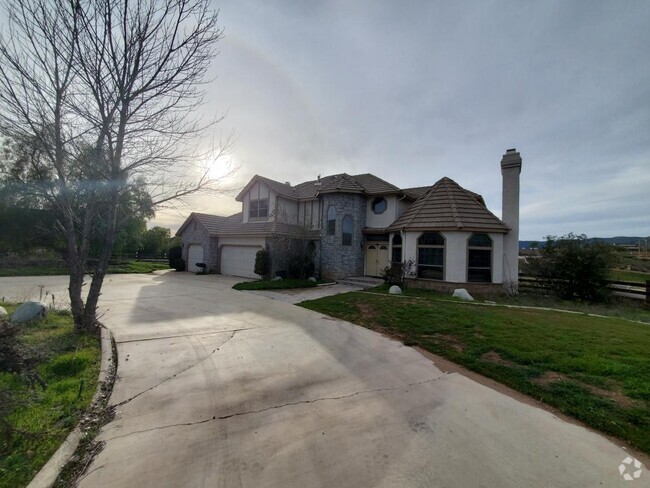
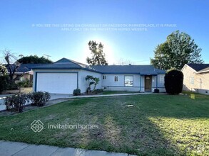
16034 Placerita Canyon Rd
Santa Clarita, CA 91387
Today
Favorites
661-733-5738
-
Bedrooms
5
-
Bathrooms
5
-
Square Feet
5,000 sq ft
-
Available
Available Now
Highlights
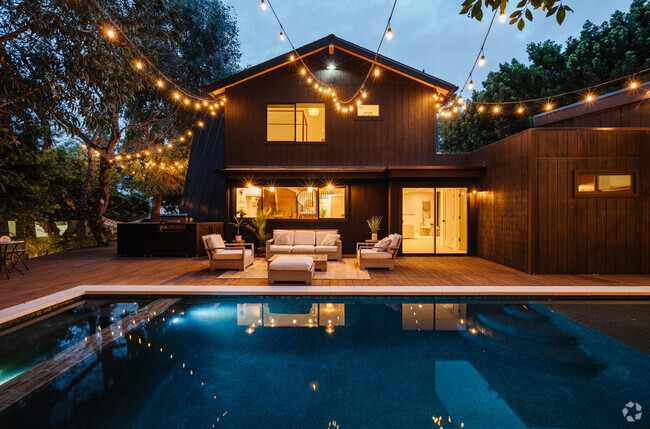
- Built in 1983 | Newly Remodeled
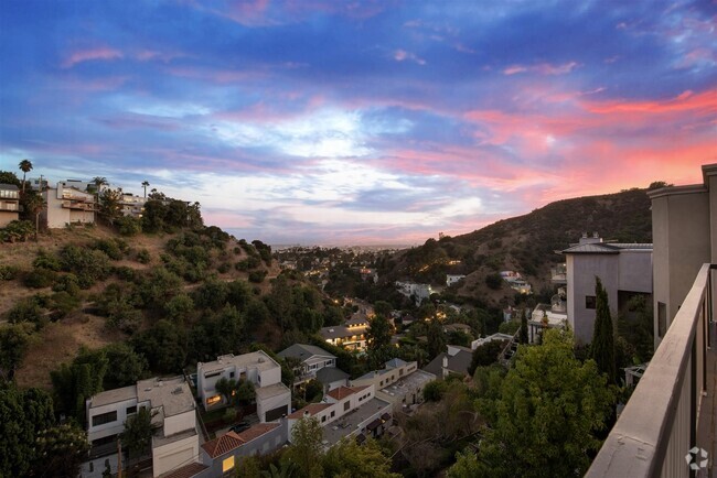
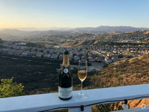
- Mountain View
- Main Floor Primary Bedroom
- Furnished
- Great Room
- Workshop
16034 Placerita Canyon Rd

Favorites
About This Home
12 Month Lease,
$50,000 deposit,
Available Now
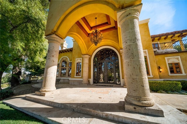
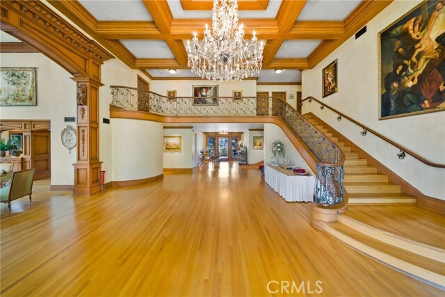
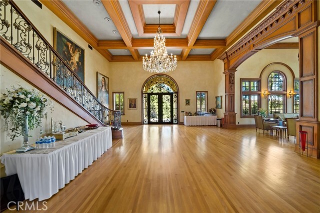
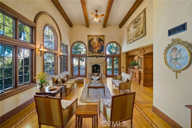
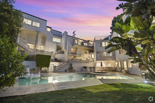
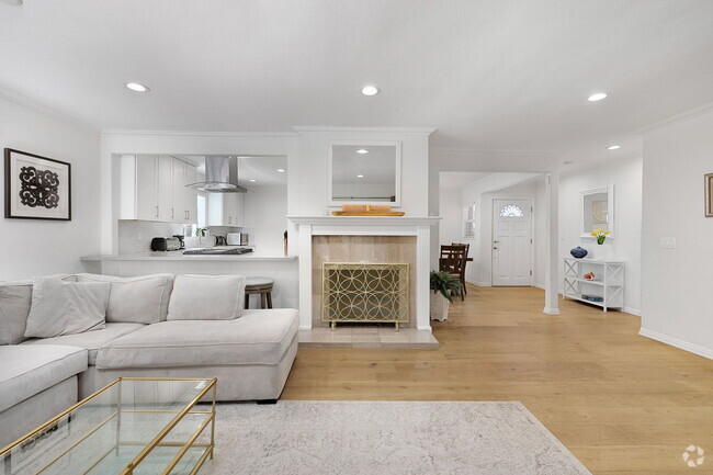
This 6.61 acre property is located in the heart of Santa Clarita on top of a mountain with incredible panoramic views. Over 5,000sqft of living space and wrap around balconies. Two stories fully remodeled in 2005. Large kitchen area with granite countertops and modern appliances. 5 bedrooms, 5 bathrooms with high ceilings and hardwood and tile floors. Master bedroom includes a sauna, two walk in closets, wrap around mirror and large multi head shower. 4 car garage has plenty of workspace and additional large fridge/freezer. Multiple patios and rose gardens overlooking the mountains make a great entertaining area. Large flat lower lot with water and power gives tenant additional opportunities. Landlord installed a helo pod nearby for instant fire protection. Incredible opportunity. This house is move in ready. $25,000 per month.
16034 Placerita Canyon Rd is a house located in Los Angeles County and the 91387 ZIP Code. This area is served by the William S. Hart Union High attendance zone.
* Price shown is base rent and may not include non-optional fees and utilities.
Price, availability, fees, and any applicable rent special are subject to change without notice.
* Square footage definitions vary. Displayed square footage is approximate.
Home Details
Home Type
Single Family Detached Home
Year Built
Built in 1983 | Newly Remodeled
Accessible Home Design
Entry on the 1st floor
Bedrooms and Bathrooms
5 Main Level Bedrooms
Primary Bedroom on Main
5 Bathrooms
Interior Spaces
Family Room with Fireplace
Furnished
Great Room
Workshop
Entryway
5,000 Sq Ft Home
2-Story Property
Laundry
Laundry Room
Listing and Financial Details
Security Deposit $50,000
12-Month Minimum Lease Term
Available 1/27/25
Assessor Parcel Number 2848012077
Lot Details
6.61 Acre Lot
No Common Walls
Density is 6-10 Units/Acre
Parking
4 Car Attached Garage
Utilities
Central Air
Conventional Septic
Views
Mountain Views
Community Details
Overview
Property is near a preserve or public land
Valley
No Home Owners Association
West Oaks Subdivision
$50,000 HOA Transfer Fee
Pet Policy
Call for details about the types of pets allowed
Pet Deposit $500
Recreation
Hiking Trails
Fees and Policies
The fees below are based on community-supplied data and may exclude additional fees and utilities.
- Parking
-
Other--
Details
Lease Options
-
12 Months
Property Information
-
Furnished Units Available
Contact
- Listed by Dustin Arklin | Keller Williams Realty Antelope Valley
- Phone Number
- Contact
-
Source
 California Regional Multiple Listing Service
Copyright 2025 © California Regional MLS. All rights reserved.
$16,107 / month
$2,625,000 Listing Price
5 Beds
•7.5 Baths
•
6,022 Sq Ft
$26,580 / month
$4,295,000 Listing Price
8 Beds
•11 Baths
•
9,719 Sq Ft
$23,897 / month
$3,899,999 Listing Price
6 Beds
•5.5 Baths
•
8,200 Sq Ft
Location
Get Directions
Amenities
- Air Conditioning
- Fireplace
- Furnished
The Antelope Valley region sits in the northernmost stretches of Los Angeles County. Antelope Valley also constitutes the western portion of the Mojave Desert, located between the Tehachapi, Sierra Pelona, and San Gabriel Mountains, which all lend stunning mountain vistas to the rentals in the region.
Antelope Valley’s largest cities include Lancaster and Palmdale, in addition to a slew of smaller cities and towns that each boast their own unique identity and sense of character. The region’s more affordable cost of living draws plenty of Los Angeles area commuters who don’t mind a longer commute time.
The rental options are just as diverse as the region itself, with an array of apartments, condos, townhomes, and houses available for rent throughout Antelope Valley. Popular spots for outdoor recreation include Angeles National Forest and Castaic Lake State Recreation Area, as well as Greater Los Angeles’ renowned beaches, which are about a two-hour drive away.
Learn more about living in Antelope Valley
Education
| Colleges & Universities | Distance | ||
|---|---|---|---|
| Colleges & Universities | Distance | ||
| Drive: | 25 min | 12.9 mi | |
| Drive: | 22 min | 15.2 mi | |
| Drive: | 29 min | 16.4 mi | |
| Drive: | 31 min | 22.5 mi |
16034 Placerita Canyon Rd is within 22 minutes or 15.2 miles from Mission College. It is also near College of the Canyons and Cal State Northridge.
Schools


Public Elementary School
Grades K-6
Nearby
Public Elementary School
Grades K-6
595 Students
Attendance Zone
Public Middle School
Grades 7-8
991 Students
Attendance Zone
Public High School
Grades 9-12
396 Students
Attendance Zone
Public High School
Grades 9-12
1,946 Students
Attendance Zone
Private Elementary School
Grades PK-1
Nearby
Private Elementary, Middle & High School
Grades K-12
424 Students
Nearby
School data provided by
 The GreatSchools Rating helps parents compare schools within a state based on a variety of school quality indicators and provides a helpful picture of how effectively each school serves all of its students. Ratings are on a scale of 1 (below average) to 10 (above average) and can include test scores, college readiness, academic progress, advanced courses, equity, discipline and attendance data. We also advise parents to visit schools, consider other information on school performance and programs, and consider family needs as part of the school selection process.
View GreatSchools Rating Methodology
View GreatSchools Rating Methodology
Transportation options available in Santa Clarita include North Hollywood Station, located 23.0 miles from 16034 Placerita Canyon Rd. 16034 Placerita Canyon Rd is near Bob Hope, located 22.1 miles or 31 minutes away, and Los Angeles International, located 39.2 miles or 52 minutes away.
| Transit / Subway | Distance | ||
|---|---|---|---|
| Transit / Subway | Distance | ||
|
|
Drive: | 31 min | 23.0 mi |
|
|
Drive: | 34 min | 25.3 mi |
|
|
Drive: | 38 min | 28.3 mi |
|
|
Drive: | 38 min | 28.5 mi |
|
|
Drive: | 39 min | 29.3 mi |
| Commuter Rail | Distance | ||
|---|---|---|---|
| Commuter Rail | Distance | ||
|
|
Drive: | 13 min | 7.3 mi |
|
|
Drive: | 15 min | 8.2 mi |
|
|
Drive: | 18 min | 10.1 mi |
|
|
Drive: | 22 min | 14.2 mi |
|
|
Drive: | 27 min | 20.2 mi |
| Airports | Distance | ||
|---|---|---|---|
| Airports | Distance | ||
|
Bob Hope
|
Drive: | 31 min | 22.1 mi |
|
Los Angeles International
|
Drive: | 52 min | 39.2 mi |
Time and distance from 16034 Placerita Canyon Rd.
| Shopping Centers | Distance | ||
|---|---|---|---|
| Shopping Centers | Distance | ||
| Drive: | 9 min | 4.7 mi | |
| Drive: | 12 min | 6.7 mi | |
| Drive: | 13 min | 7.2 mi |
16034 Placerita Canyon Rd has 3 shopping centers within 7.2 miles, which is about a 13-minute drive. The miles and minutes will be for the farthest away property.
| Parks and Recreation | Distance | ||
|---|---|---|---|
| Parks and Recreation | Distance | ||
|
Placerita Canyon State Park
|
Drive: | 4 min | 2.2 mi |
|
Placerita Canyon Nature Center
|
Drive: | 6 min | 3.6 mi |
|
Wildlife Waystation
|
Drive: | 20 min | 9.8 mi |
|
El Cariso Regional Park
|
Drive: | 22 min | 15.3 mi |
|
Veterans Memorial Park
|
Drive: | 27 min | 15.9 mi |
16034 Placerita Canyon Rd has 5 parks within 15.9 miles, including Placerita Canyon State Park, Placerita Canyon Nature Center, and Veterans Memorial Park.
| Hospitals | Distance | ||
|---|---|---|---|
| Hospitals | Distance | ||
| Drive: | 18 min | 10.0 mi | |
| Drive: | 21 min | 13.4 mi | |
| Drive: | 20 min | 13.9 mi |
16034 Placerita Canyon Rd has 3 hospitals within 13.9 miles, the nearest is Henry Mayo Newhall Hospital which is 10.0 miles away and a 18 minute drive.
| Military Bases | Distance | ||
|---|---|---|---|
| Military Bases | Distance | ||
| Drive: | 53 min | 41.8 mi | |
| Drive: | 85 min | 51.8 mi |
16034 Placerita Canyon Rd is 41.8 miles from Los Angeles Air Force Base, and is convenient to other military bases, including Edwards Air Force Base North Antelope Valley.
You May Also Like
Similar Rentals Nearby
What Are Walk Score®, Transit Score®, and Bike Score® Ratings?
Walk Score® measures the walkability of any address. Transit Score® measures access to public transit. Bike Score® measures the bikeability of any address.
What is a Sound Score Rating?
A Sound Score Rating aggregates noise caused by vehicle traffic, airplane traffic and local sources

16034 Placerita Canyon Rd
Santa Clarita, CA 91387