$3,890 / Month
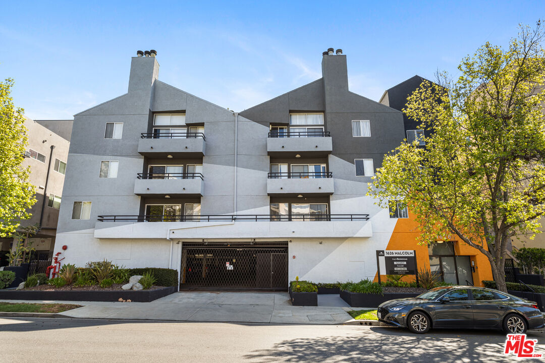
1626 Malcolm Ave Unit 305
Los Angeles, CA 90024
1 Day Ago
Favorites
310-988-8923
-
Bedrooms
2
-
Bathrooms
2
-
Square Feet
1,250 sq ft
-
Available
Available Now
Highlights
- Elevator
- Auto Driveway Gate
- City Lights View
- Contemporary Architecture
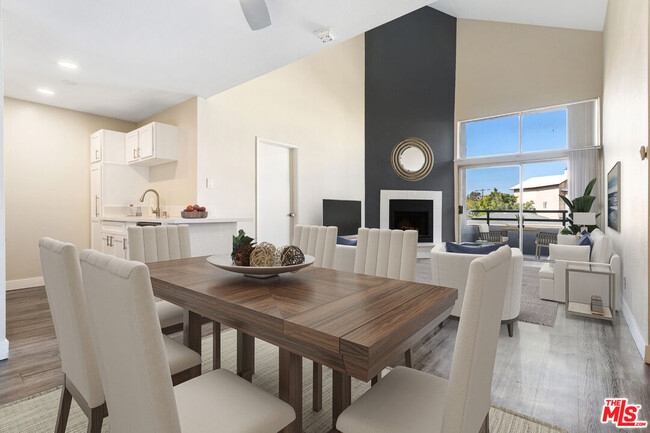
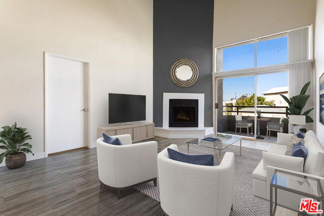
- High Ceiling
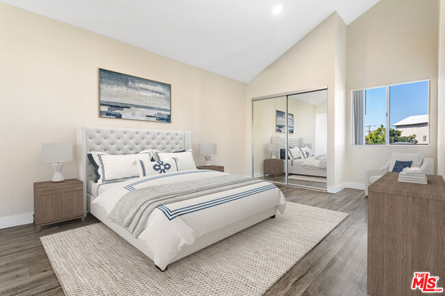
- Den with Fireplace
1626 Malcolm Ave Unit 305

Favorites
About This Home
$4,190 deposit,
Available Now
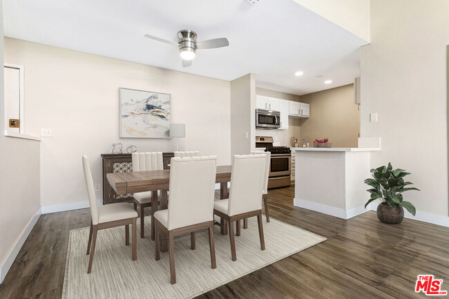
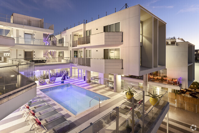
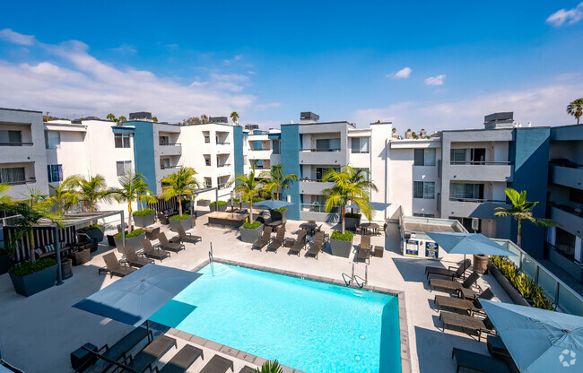
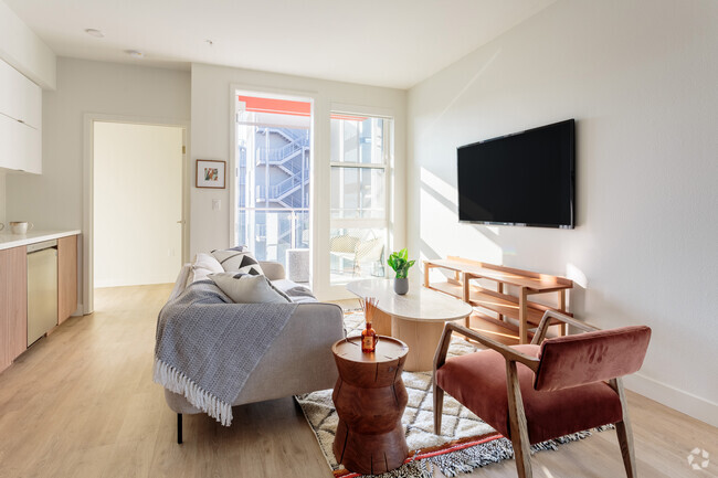
1626 Malcolm, a newer complex from Nayssan Properties. This bold and contemporary newer building with amazing EXTREMELY HIGH CEILING PENTHOUSE LARGE 2-bedroom, 2-bathroom unit. 2 LARGE BEDROOMS which are separate from each other which is great for privacy! The apartment has a spacious open floorplan with OVER 15 FOOT high ceilings and fireplace! Equipped with great appliances. IN UNIT WASHER DRYER! Large private balconies with great views. Bedrooms are large with plenty of closet space. Two parking spaces included! One block away from Westwood Boulevard with some of the best restaurants in West Los Angeles and a few minutes walk from Sprouts, Bristol Farms & other local markets and short drive to UCLA, Century City, and Beverly Hills. SEE REMARKS FOR SHOWING INSTRUCTIONS
1626 Malcolm Ave is an apartment community located in Los Angeles County and the 90024 ZIP Code.
* Price shown is base rent and may not include non-optional fees and utilities.
Price, availability, fees, and any applicable rent special are subject to change without notice.
* Square footage definitions vary. Displayed square footage is approximate.
Home Details
Home Type
Condominium
Year Built
Built in 1987 | Remodeled
Bedrooms and Bathrooms
Walk-In Closet
2 Full Bathrooms
2 Bedrooms
Home Design
Contemporary Architecture
Fire Rated Drywall
Home Security
Intercom
Fire and Smoke Detector
Fire Sprinkler System
Security Lights
Interior Spaces
Elevator
Dining Room with Fireplace
Den with Fireplace
High Ceiling
Double Door Entry
Living Room
Sliding Doors
Laminate Flooring
1,250 Sq Ft Home
4-Story Property
Kitchen
Breakfast Area or Nook
Oven or Range
Freezer
Ice Maker
Microwave
Dishwasher
Laundry
Dryer
Laundry in unit
Washer
Listing and Financial Details
Security Deposit $4,190
12 Month Lease Term
Assessor Parcel Number 4325-025-077
Tenant pays for cable TV, electricity, gas, water, trash collection
Lot Details
0.26 Acre Lot
Sprinkler System
Outdoor Features
Balcony
Parking
Auto Driveway Gate
Controlled Entrance
Assigned Parking
Covered Parking
Private Parking
2 Covered Spaces
Off-Site Parking
2 Parking Spaces
Utilities
Central Heating and Cooling System
Water Heater
Cable TV Available
Views
City Lights Views
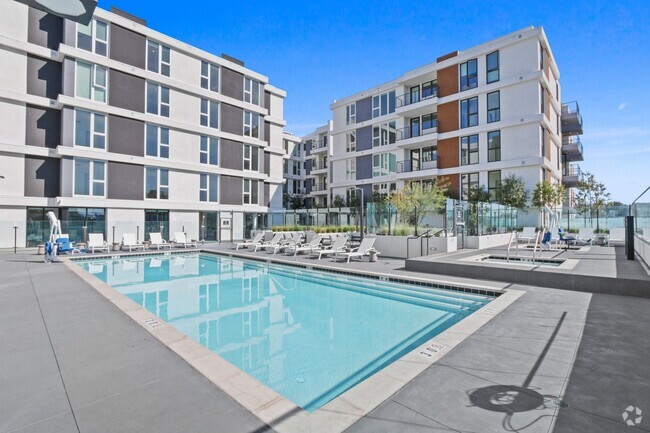
Community Details
Overview
Low-Rise Condominium
Pet Policy
Call for details about the types of pets allowed
Security
Card or Code Access
Fees and Policies
The fees below are based on community-supplied data and may exclude additional fees and utilities.
Pet policies are negotiable.
- Parking
-
Other--
Contact
- Listed by Jasmine Lawi | Jasmine Lawi, Broker
- Phone Number
- Contact
-
Source
 MLS(TM)/CLAW
Copyright 2025 TheMLS/CLAW. All rights reserved. Information is deemed reliable but not guaranteed.
Location
Get Directions
Amenities
- Washer/Dryer
- Cable Ready
- Dishwasher
- Microwave
- Refrigerator
- Freezer
- Vinyl Flooring
- Den
- Views
- Controlled Access
- Elevator
Home to UCLA, Westwood lies on the west side of the city and is considered to be one of Los Angeles’ premier neighborhoods. Bordered by Beverly Hills, Bel Air, Brentwood, and Century City, multimillion dollar homes populate the landscape and students pay a premium to rent near campus.
The university itself serves as a major cultural center for the community, including on-campus attractions (such as the Fowler Museum and the Franklin D. Murphy Sculpture Garden) and university-affiliated venues off-campus (The Hammer Museum, the Geffen Playhouse), as well as the presence of thousands of students and faculty members throughout the neighborhood.
Directly south of campus, Westwood Village is a historic shopping district that features blocks of restaurants and businesses catering to both students and the neighborhood’s larger workforce. Many prominent corporations and law offices are found along Wilshire Boulevard, one of the busiest east-west transit corridors across the city.
Learn more about living in Westwood
Education
| Colleges & Universities | Distance | ||
|---|---|---|---|
| Colleges & Universities | Distance | ||
| Drive: | 4 min | 1.4 mi | |
| Drive: | 8 min | 2.9 mi | |
| Drive: | 9 min | 3.6 mi | |
| Drive: | 9 min | 3.7 mi |
1626 Malcolm Ave Unit 305 is within 4 minutes or 1.4 miles from UCLA. It is also near Santa Monica Coll., Academy and The Art Inst., Los Angeles.
Transportation options available in Los Angeles include Westwood/Rancho Park, located 1.6 miles from 1626 Malcolm Ave Unit 305. 1626 Malcolm Ave Unit 305 is near Los Angeles International, located 10.1 miles or 17 minutes away, and Bob Hope, located 18.5 miles or 28 minutes away.
| Transit / Subway | Distance | ||
|---|---|---|---|
| Transit / Subway | Distance | ||
|
|
Drive: | 4 min | 1.6 mi |
| Drive: | 4 min | 1.7 mi | |
|
|
Drive: | 7 min | 2.5 mi |
|
|
Drive: | 7 min | 3.0 mi |
|
|
Drive: | 9 min | 4.6 mi |
| Commuter Rail | Distance | ||
|---|---|---|---|
| Commuter Rail | Distance | ||
|
|
Drive: | 27 min | 13.8 mi |
|
|
Drive: | 22 min | 14.0 mi |
|
|
Drive: | 22 min | 14.9 mi |
|
|
Drive: | 28 min | 18.5 mi |
|
|
Drive: | 28 min | 19.3 mi |
| Airports | Distance | ||
|---|---|---|---|
| Airports | Distance | ||
|
Los Angeles International
|
Drive: | 17 min | 10.1 mi |
|
Bob Hope
|
Drive: | 28 min | 18.5 mi |
Time and distance from 1626 Malcolm Ave Unit 305.
| Shopping Centers | Distance | ||
|---|---|---|---|
| Shopping Centers | Distance | ||
| Walk: | 8 min | 0.5 mi | |
| Walk: | 8 min | 0.5 mi | |
| Walk: | 9 min | 0.5 mi |
1626 Malcolm Ave Unit 305 has 3 shopping centers within 0.5 mile, which is about a 9-minute walk. The miles and minutes will be for the farthest away property.
| Parks and Recreation | Distance | ||
|---|---|---|---|
| Parks and Recreation | Distance | ||
|
Mathias Botanical Garden
|
Drive: | 4 min | 1.2 mi |
|
Hannah Carter Japanese Garden
|
Drive: | 8 min | 2.9 mi |
|
Virginia Robinson Gardens
|
Drive: | 10 min | 3.7 mi |
|
Zimmer Children's Museum
|
Drive: | 10 min | 4.9 mi |
|
Will Rogers State Historic Park
|
Drive: | 19 min | 7.2 mi |
1626 Malcolm Ave Unit 305 has 5 parks within 7.2 miles, including Mathias Botanical Garden, Hannah Carter Japanese Garden, and Virginia Robinson Gardens.
| Hospitals | Distance | ||
|---|---|---|---|
| Hospitals | Distance | ||
| Drive: | 4 min | 1.3 mi | |
| Drive: | 4 min | 1.4 mi | |
| Drive: | 8 min | 3.2 mi |
1626 Malcolm Ave Unit 305 has 3 hospitals within 3.2 miles, the nearest is Ronald Reagan UCLA Medical Center which is 1.3 miles away and a 4 minute drive.
| Military Bases | Distance | ||
|---|---|---|---|
| Military Bases | Distance | ||
| Drive: | 18 min | 12.6 mi |
1626 Malcolm Ave Unit 305 is 12.6 miles and a 18 minute drive from Los Angeles Air Force Base.
You May Also Like
Similar Rentals Nearby


What Are Walk Score®, Transit Score®, and Bike Score® Ratings?
Walk Score® measures the walkability of any address. Transit Score® measures access to public transit. Bike Score® measures the bikeability of any address.
What is a Sound Score Rating?
A Sound Score Rating aggregates noise caused by vehicle traffic, airplane traffic and local sources

1626 Malcolm Ave
Los Angeles, CA 90024