
$8,700
/ Month
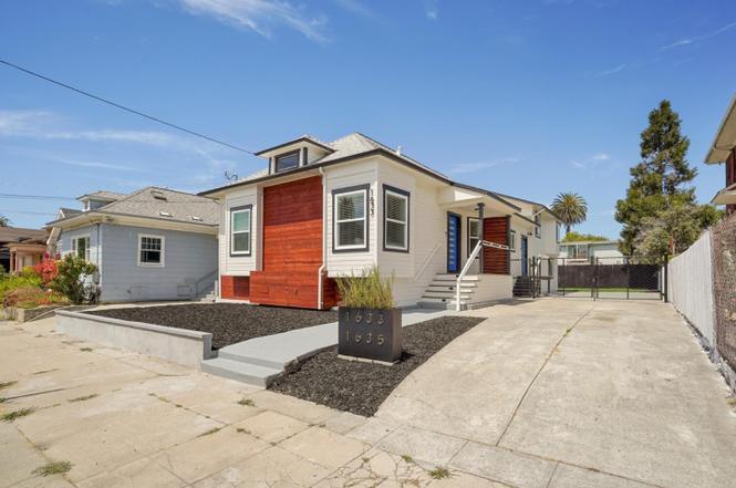
1633 62nd St
Berkeley, CA 94703
2 Weeks Ago
|
Edit
Favorites
1633 62nd St

Favorites
Check Back Soon for Upcoming Availability
| Beds | Baths | Average SF |
|---|---|---|
| 5 Bedrooms 5 Bedrooms 5 Br | 3 Baths 3 Baths 3 Ba | 2,650 SF |
About This Property
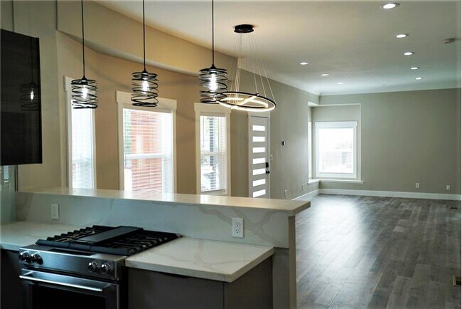
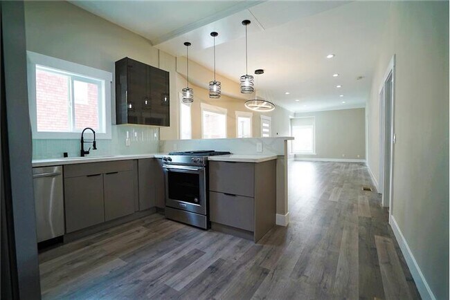
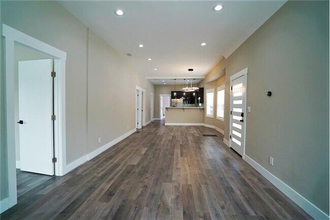
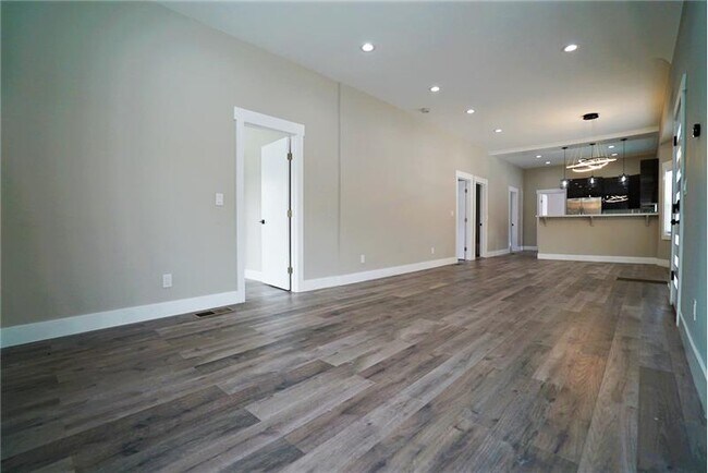
Brand new open kitchens with/dining area & new stainless-steel appliances Ample kitchen cabinet storage and counter space, quartz countertops Spacious primary bedroom with en-suite bathroom and walk in closet Long living room/dining room combo with lots of light and high ceilings & breakfast bar New hardwood floors throughout Bright natural lighting throughout All new LED light fixtures throughout Custom doors Keyless entry Nest system Built-in bench window Two Washer & Dryer Hook Ups 4+ Car Off Street Parking Large Yard
1633 62nd St is a condo located in Alameda County and the 94703 ZIP Code. This area is served by the Berkeley Unified attendance zone.
Location
Get Directions
Located just minutes from Downtown Berkeley, South Berkeley encompasses part of historic Rancho San Antonio. Today, it has become a mecca for sports as well as cool apartments. The Ashby Stage is a great place to see a show, and it’s down the road from the Berkeley Bowl supermarket. Adeline Street is where you’ll find most restaurants, nightlife, and Ashby BART Station.
Grove Park offers an array of outdoor amenities to locals including sports courts and a playground. When you live in South Berkeley, you’re close to the University of California, Berkeley and five miles from Oakland.
Learn more about living in South BerkeleyBelow are rent ranges for similar nearby apartments
| Beds | Average Size | Lowest | Typical | Premium |
|---|---|---|---|---|
| Studio Studio Studio | 462-473 Sq Ft | $1,070 | $2,520 | $4,503 |
| 1 Bed 1 Bed 1 Bed | 543-553 Sq Ft | $600 | $2,346 | $5,090 |
| 2 Beds 2 Beds 2 Beds | 793-801 Sq Ft | $699 | $2,837 | $10,040 |
| 3 Beds 3 Beds 3 Beds | 1131-1140 Sq Ft | $775 | $4,755 | $8,700 |
| 4 Beds 4 Beds 4 Beds | 1315-1317 Sq Ft | $890 | $4,387 | $16,500 |
Education
| Colleges & Universities | Distance | ||
|---|---|---|---|
| Colleges & Universities | Distance | ||
| Drive: | 6 min | 1.9 mi | |
| Drive: | 6 min | 2.3 mi | |
| Drive: | 10 min | 3.0 mi | |
| Drive: | 7 min | 3.3 mi |
1633 62nd St is within 6 minutes or 1.9 miles from Berkeley City College. It is also near Samuel Merritt University and UC Berkeley.
Schools


Public Elementary School
Grades K-5
270 Students
Nearby
Public Elementary School
Grades K-5
370 Students
Attendance Zone
Public Elementary School
Grades K-5
459 Students
Attendance Zone
Public Middle School
Grades 6-8
596 Students
Attendance Zone
Public High School
Grades 9-12
3,204 Students
Attendance Zone
Private Elementary, Middle & High School
Grades K-12
Nearby
Private Elementary & Middle School
Grades PK-8
367 Students
Nearby
Private Elementary School
Grades K-6
Nearby
Private Elementary School
Grades PK-5
Nearby
School data provided by
 The GreatSchools Rating helps parents compare schools within a state based on a variety of school quality indicators and provides a helpful picture of how effectively each school serves all of its students. Ratings are on a scale of 1 (below average) to 10 (above average) and can include test scores, college readiness, academic progress, advanced courses, equity, discipline and attendance data. We also advise parents to visit schools, consider other information on school performance and programs, and consider family needs as part of the school selection process.
View GreatSchools Rating Methodology
Data provided by GreatSchools.org © 2025. All rights reserved.
View GreatSchools Rating Methodology
Data provided by GreatSchools.org © 2025. All rights reserved.
Transportation options available in Berkeley include Ashby Station, located 0.5 mile from 1633 62nd St. 1633 62nd St is near Metro Oakland International, located 12.8 miles or 20 minutes away, and San Francisco International, located 22.6 miles or 35 minutes away.
| Transit / Subway | Distance | ||
|---|---|---|---|
| Transit / Subway | Distance | ||
|
|
Walk: | 10 min | 0.5 mi |
|
|
Drive: | 6 min | 2.0 mi |
|
|
Drive: | 7 min | 2.3 mi |
|
|
Drive: | 6 min | 2.5 mi |
|
|
Drive: | 7 min | 3.4 mi |
| Commuter Rail | Distance | ||
|---|---|---|---|
| Commuter Rail | Distance | ||
|
|
Drive: | 3 min | 1.3 mi |
|
|
Drive: | 8 min | 2.8 mi |
|
|
Drive: | 9 min | 4.5 mi |
| Drive: | 15 min | 9.8 mi | |
| Drive: | 17 min | 10.2 mi |
| Airports | Distance | ||
|---|---|---|---|
| Airports | Distance | ||
|
Metro Oakland International
|
Drive: | 20 min | 12.8 mi |
|
San Francisco International
|
Drive: | 35 min | 22.6 mi |
Time and distance from 1633 62nd St.
| Shopping Centers | Distance | ||
|---|---|---|---|
| Shopping Centers | Distance | ||
| Drive: | 3 min | 1.2 mi | |
| Drive: | 3 min | 1.2 mi | |
| Drive: | 3 min | 1.2 mi |
1633 62nd St has 3 shopping centers within 1.2 miles, which is about a 3-minute drive. The miles and minutes will be for the farthest away property.
| Parks and Recreation | Distance | ||
|---|---|---|---|
| Parks and Recreation | Distance | ||
|
Willard Park
|
Drive: | 5 min | 1.7 mi |
|
Habitot Children's Museum
|
Drive: | 5 min | 1.7 mi |
|
Strawberry Creek Park
|
Drive: | 5 min | 2.0 mi |
|
People's Park
|
Drive: | 6 min | 2.1 mi |
|
San Francisco Bay Trail (at Emeryville)
|
Drive: | 5 min | 2.2 mi |
1633 62nd St has 5 parks within 2.2 miles, including Willard Park, Habitot Children's Museum, and People's Park.
| Hospitals | Distance | ||
|---|---|---|---|
| Hospitals | Distance | ||
| Walk: | 17 min | 0.9 mi | |
| Drive: | 4 min | 1.4 mi | |
| Drive: | 5 min | 2.3 mi |
1633 62nd St has 3 hospitals within 2.3 miles, the nearest is Children's Hospital & Research Center Oakland which is 0.9 mile away and a 17 minute walk.
| Military Bases | Distance | ||
|---|---|---|---|
| Military Bases | Distance | ||
| Drive: | 14 min | 5.4 mi | |
| Drive: | 16 min | 6.9 mi |
1633 62nd St is 5.4 miles from Oakland Army Base, and is convenient to other military bases, including Alameda/US Naval Air Station Alameda.
You May Also Like
Similar Rentals Nearby


What Are Walk Score®, Transit Score®, and Bike Score® Ratings?
Walk Score® measures the walkability of any address. Transit Score® measures access to public transit. Bike Score® measures the bikeability of any address.
What is a Sound Score Rating?
A Sound Score Rating aggregates noise caused by vehicle traffic, airplane traffic and local sources

1633 62nd St
Berkeley, CA 94703