

$2,850 / Month
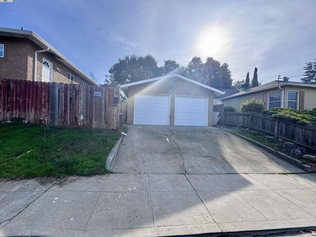
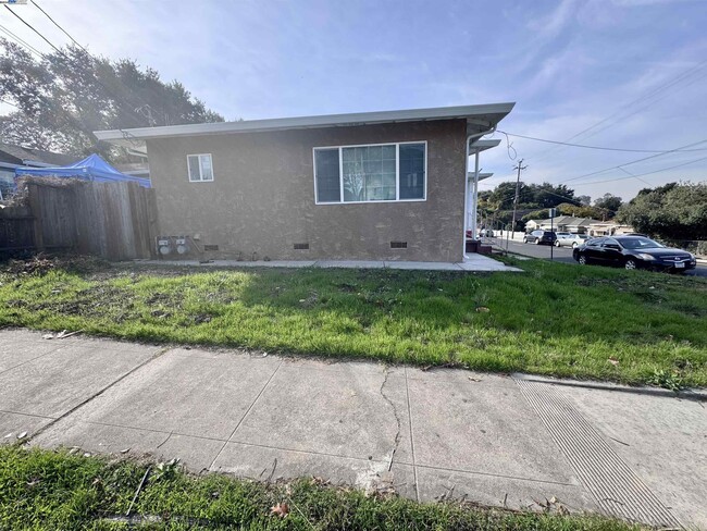
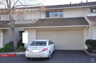
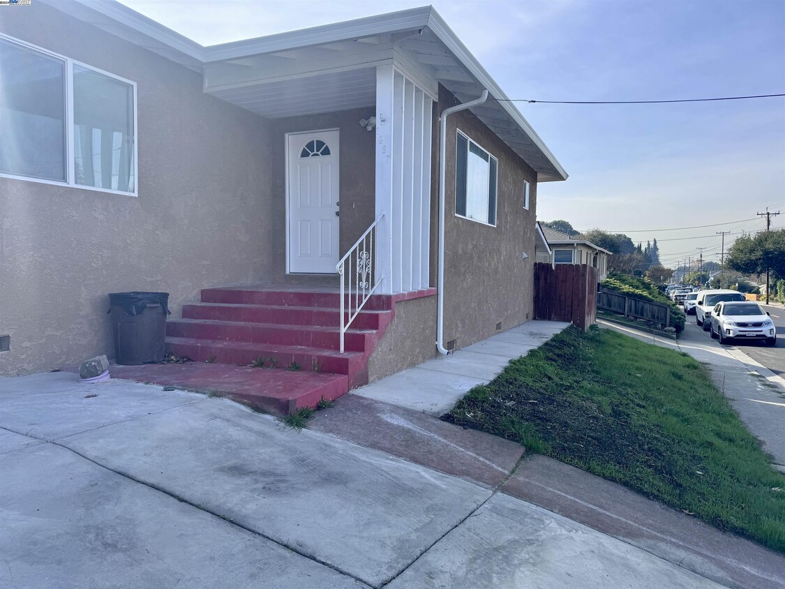
1697 C St
Hayward, CA 94541
Today
Favorites
510-714-8759
-
Bedrooms
2
-
Bathrooms
1
-
Square Feet
756 sq ft
-
Available
Available Now
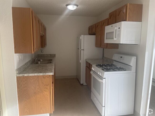
Highlights
- Contemporary Architecture
- Stone Countertops
- 1 Car Detached Garage
- No Cooling
- Wall Furnace
- 1-Story Property
1697 C St

Favorites
Home Details
Home Type
Duplex
Year Built
Built in 1951
Bedrooms and Bathrooms
1 Full Bathroom
2 Bedrooms
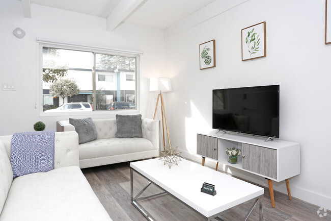
Home Design
Contemporary Architecture
Stucco
Interior Spaces
Laminate Flooring
1-Story Property
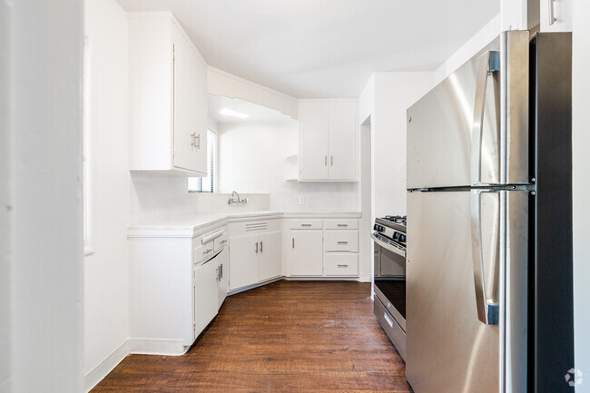
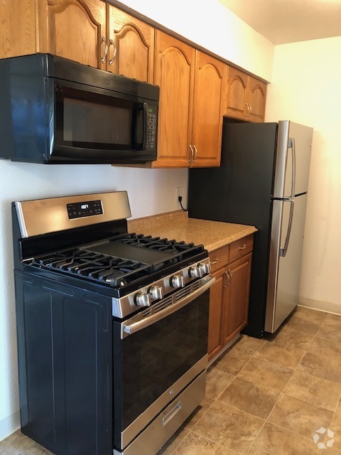
Kitchen
Stone Countertops
Gas Range
Laundry
Washer and Dryer Hookup
Lot Details
5,017 Sq Ft Lot
Irregular Lot
Parking
1 Car Detached Garage
Utilities
No Cooling
Wall Furnace
Community Details
Overview
No Home Owners Association
Bay East Association
Hayward Area Subdivision
756 Sq Ft Building
Contact
- Listed by Anil Sikka | Real Estate Center
- Phone Number (510) 714-8759
- Contact
-
Source
 Bay East Association of REALTORS ®
Copyright© 2025 Bay East, Contra Costa, bridgeMLS. All rights reserved. All information provided by the listing agent/broker is deemed reliable but is not guaranteed and should be independently verified.
$2,934 / month
$385,000 Listing Price
2 Beds
•1.5 Baths
•
1,024 Sq Ft
$2,757 / month
$425,000 Listing Price
2 Beds
•2 Baths
•
1,254 Sq Ft
$1,799 / month
$244,000 Listing Price
2 Beds
•1 Baths
•
747 Sq Ft
Location
Get Directions
Situated in the northeastern-most part of Hayward, Upper B Street offers plenty of affordable rental options and convenient amenities along with easy access to several nearby highways and BART stations. Aside from its remarkable accessibility, Upper B Street’s quiet boulevards lined with charming bungalows and mature trees make the neighborhood stand out.
Located about one mile northeast of Downtown Hayward, Upper B Street is surrounded by a host of lush green spaces for residents to enjoy as well as numerous urban amenities. Hayward Japanese Gardens, Sulphur Creek Nature Center, Don Castro Regional Recreation Area, and Lake Chabot Regional Park are all situated within close proximity to the neighborhood.
The many metropolitan delights of San Francisco are about 27 miles northwest of Upper B Street. Southland Mall offers a bevy of shopping and dining opportunities a little closer to home, sitting just three miles southwest of the neighborhood.
Learn more about living in Upper B Street
Education
| Colleges & Universities | Distance | ||
|---|---|---|---|
| Colleges & Universities | Distance | ||
| Drive: | 8 min | 2.9 mi | |
| Drive: | 10 min | 4.5 mi | |
| Drive: | 19 min | 12.3 mi | |
| Drive: | 23 min | 14.1 mi |
1697 C St is within 8 minutes or 2.9 miles from Cal State East Bay. It is also near Chabot College and Mills College.
Schools
Charter Elementary School
Grades K-5
483 Students
Nearby
5
Out of 10
Public Elementary School
Grades K-6
562 Students
Attendance Zone
4
Out of 10
Public Middle School
Grades 7-8
545 Students
Attendance Zone
5
Out of 10
Public High School
Grades 9-12
1,712 Students
Attendance Zone
5
Out of 10
Private Elementary, Middle & High School
Grades 4-12
Nearby
Private Elementary & Middle School
Grades K-8
203 Students
Nearby
Private Elementary School
Grades 1-6
Nearby
Private Middle & High School
Grades 7 & 9-11
Nearby
Private Middle & High School
Grades 9
Nearby
School data provided by
GreatSchools
The GreatSchools Rating helps parents compare schools within a state based on a variety of school quality indicators and provides a helpful picture of how effectively each school serves all of its students. Ratings are on a scale of 1 (below average) to 10 (above average) and can include test scores, college readiness, academic progress, advanced courses, equity, discipline and attendance data. We also advise parents to visit schools, consider other information on school performance and programs, and consider family needs as part of the school selection process.
Transportation options available in Hayward include Hayward Station, located 1.4 miles from 1697 C St. 1697 C St is near Metro Oakland International, located 11.0 miles or 17 minutes away, and San Francisco International, located 23.8 miles or 33 minutes away.
| Transit / Subway | Distance | ||
|---|---|---|---|
| Transit / Subway | Distance | ||
|
|
Drive: | 3 min | 1.4 mi |
|
|
Drive: | 6 min | 3.1 mi |
|
|
Drive: | 11 min | 4.0 mi |
|
|
Drive: | 9 min | 4.9 mi |
|
|
Drive: | 13 min | 8.3 mi |
| Commuter Rail | Distance | ||
|---|---|---|---|
| Commuter Rail | Distance | ||
|
|
Drive: | 5 min | 2.1 mi |
| Drive: | 5 min | 2.1 mi | |
| Drive: | 19 min | 11.0 mi | |
| Drive: | 20 min | 13.6 mi | |
|
|
Drive: | 20 min | 15.1 mi |
| Airports | Distance | ||
|---|---|---|---|
| Airports | Distance | ||
|
Metro Oakland International
|
Drive: | 17 min | 11.0 mi |
|
San Francisco International
|
Drive: | 33 min | 23.8 mi |
Time and distance from 1697 C St.
| Shopping Centers | Distance | ||
|---|---|---|---|
| Shopping Centers | Distance | ||
| Walk: | 9 min | 0.5 mi | |
| Walk: | 10 min | 0.5 mi | |
| Walk: | 12 min | 0.7 mi |
1697 C St has 3 shopping centers within 0.7 mile, which is about a 12-minute walk. The miles and minutes will be for the farthest away property.
| Parks and Recreation | Distance | ||
|---|---|---|---|
| Parks and Recreation | Distance | ||
|
Sulphur Creek Nature Center
|
Walk: | 11 min | 0.6 mi |
|
Don Castro Regional Recreation Area
|
Drive: | 3 min | 1.3 mi |
|
Cull Canyon Regional Recreation Area
|
Drive: | 8 min | 2.8 mi |
|
Lake Chabot Regional Park
|
Drive: | 9 min | 4.5 mi |
|
Hayward Regional Shoreline
|
Drive: | 16 min | 7.7 mi |
1697 C St has 5 parks within 7.7 miles, including Sulphur Creek Nature Center, Don Castro Regional Recreation Area, and Cull Canyon Regional Recreation Area.
| Hospitals | Distance | ||
|---|---|---|---|
| Hospitals | Distance | ||
| Drive: | 9 min | 4.3 mi | |
| Drive: | 8 min | 4.8 mi | |
| Drive: | 11 min | 7.4 mi |
1697 C St has 3 hospitals within 7.4 miles, the nearest is St. Rose Hospital which is 4.3 miles away and a 9 minute drive.
| Military Bases | Distance | ||
|---|---|---|---|
| Military Bases | Distance | ||
| Drive: | 28 min | 18.5 mi |
1697 C St is 18.5 miles and a 28 minute drive from Alameda/US Naval Air Station Alameda.
You May Also Like
Similar Rentals Nearby
-
-
-
-
-
-
-
-
-
-
 $1,2503 Beds, 2.5 Baths, 1,425 sq ftTownhome for Rent


What Are Walk Score®, Transit Score®, and Bike Score® Ratings?
Walk Score® measures the walkability of any address. Transit Score® measures access to public transit. Bike Score® measures the bikeability of any address.
What is a Sound Score Rating?
A Sound Score Rating aggregates noise caused by vehicle traffic, airplane traffic and local sources
1697 C St
Hayward, CA 94541