

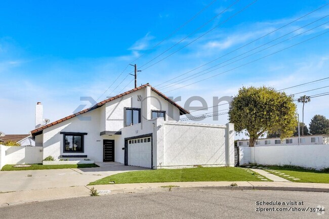
$5,000 / Month
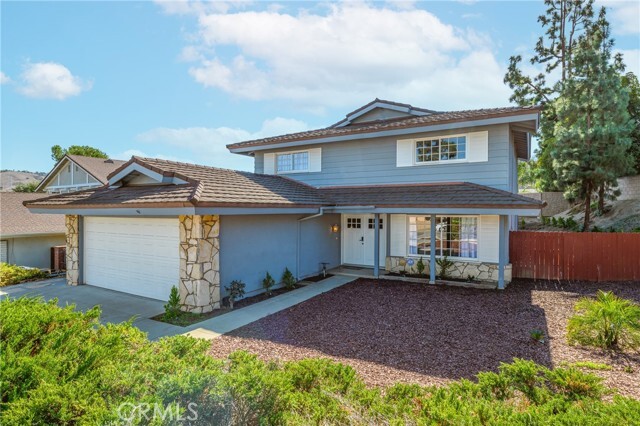
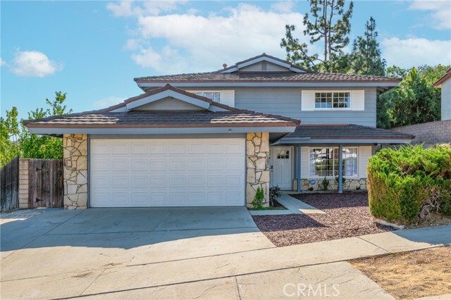
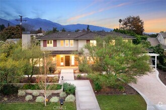
17958 Nearbank Dr
Rowland Heights, CA 91748
Today
Favorites
626-500-8868
-
Bedrooms
5
-
Bathrooms
3
-
Square Feet
2,380 sq ft
-
Available
Available Now
Highlights
- Main Floor Primary Bedroom
- 2 Car Attached Garage
- Laundry Room
- Central Heating and Cooling System
- Back Yard
17958 Nearbank Dr

Favorites
17958 Nearbank Dr is a house located in Los Angeles County and the 91748 ZIP Code. This area is served by the Rowland Unified attendance zone.
* Price shown is base rent and may not include non-optional fees and utilities.
Price, availability, fees, and any applicable rent special are subject to change without notice.
* Square footage definitions vary. Displayed square footage is approximate.
Home Details
Home Type
Single Family Detached Home
Year Built
Built in 1967
Accessible Home Design
Entry on the 1st floor
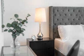
Bedrooms and Bathrooms
5 Bedrooms | 1 Primary Bedroom on Main
3 Full Bathrooms
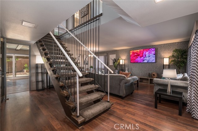
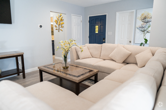
Interior Spaces
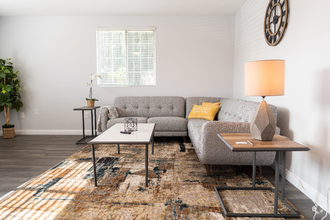
Family Room with Fireplace
2,380 Sq Ft Home
2-Story Property
Furniture Can Be Negotiated
Laundry
Laundry Room
Listing and Financial Details
Security Deposit $5,000
12-Month Minimum Lease Term
Available 3/24/25
Tax Lot 26
Tax Tract Number 25042
Assessor Parcel Number 8265022011
Rent includes gardener
Lot Details
7,374 Sq Ft Lot
No Common Walls
Back Yard
Property is zoned LCRA09
Parking
2 Car Attached Garage
Utilities
Central Heating and Cooling System
Community Details
Overview
No Home Owners Association
Pet Policy
Breed Restrictions
Pet Deposit $500
Fees and Policies
The fees below are based on community-supplied data and may exclude additional fees and utilities.
- Parking
-
Other--
Details
Lease Options
-
12 Months
Contact
- Listed by Derry Liu | GoGo Realtors R.H Corp.
- Phone Number
- Contact
-
Source
 California Regional Multiple Listing Service
Copyright 2025 © California Regional MLS. All rights reserved.
Location
Get Directions
Amenities
- Air Conditioning
- Heating
- Fireplace
Located approximately 20 miles east of Los Angeles, Rowland is a small neighborhood in the City of Industry. This prosperous community sits at the south end of the San Gabriel Valley and offers a central location for commuters. With easy access to shopping and major roadways, Rowland serves its residents with plenty of convenience, while its parks and wilderness areas let you stay connected to California’s natural beauty. Residents enjoy the abundant entertainment options, including retailers, movie theaters, fitness centers, department stores, and restaurants, as well as outdoor options like Peter F. Schabarum Regional Park, a 575-acre park with tennis courts and beautiful nature trails.
Learn more about living in Rowland
Education
| Colleges & Universities | Distance | ||
|---|---|---|---|
| Colleges & Universities | Distance | ||
| Drive: | 16 min | 8.6 mi | |
| Drive: | 15 min | 8.8 mi | |
| Drive: | 18 min | 9.6 mi | |
| Drive: | 19 min | 10.4 mi |
17958 Nearbank Dr is within 15 minutes or 8.8 miles from Mt. San Antonio College. It is also near Fullerton College and Whittier College.
Schools


Public Elementary School
Grades K-6
438 Students
Attendance Zone
Public Elementary School
Grades K-6
329 Students
Nearby
Public Middle School
Grades 7-8
648 Students
Attendance Zone
Public High School
Grades 9-12
2,025 Students
Attendance Zone
Private Elementary School
Grades K
Nearby
Private Elementary, Middle & High School
Grades 1-12
23 Students
Nearby
Private Elementary, Middle & High School
Grades PK-12
582 Students
Nearby
School data provided by
 The GreatSchools Rating helps parents compare schools within a state based on a variety of school quality indicators and provides a helpful picture of how effectively each school serves all of its students. Ratings are on a scale of 1 (below average) to 10 (above average) and can include test scores, college readiness, academic progress, advanced courses, equity, discipline and attendance data. We also advise parents to visit schools, consider other information on school performance and programs, and consider family needs as part of the school selection process.
View GreatSchools Rating Methodology
View GreatSchools Rating Methodology
Transportation options available in Rowland Heights include Azusa Downtown Station, located 13.0 miles from 17958 Nearbank Dr. 17958 Nearbank Dr is near Ontario International, located 22.2 miles or 30 minutes away, and Long Beach (Daugherty Field), located 30.2 miles or 41 minutes away.
| Transit / Subway | Distance | ||
|---|---|---|---|
| Transit / Subway | Distance | ||
| Drive: | 22 min | 13.0 mi | |
| Drive: | 26 min | 14.1 mi | |
| Drive: | 25 min | 14.2 mi | |
| Drive: | 26 min | 18.4 mi | |
| Drive: | 25 min | 19.2 mi |
| Commuter Rail | Distance | ||
|---|---|---|---|
| Commuter Rail | Distance | ||
|
|
Drive: | 10 min | 5.6 mi |
|
|
Drive: | 17 min | 9.3 mi |
|
|
Drive: | 19 min | 11.0 mi |
|
|
Drive: | 19 min | 11.1 mi |
|
|
Drive: | 21 min | 12.2 mi |
| Airports | Distance | ||
|---|---|---|---|
| Airports | Distance | ||
|
Ontario International
|
Drive: | 30 min | 22.2 mi |
|
Long Beach (Daugherty Field)
|
Drive: | 41 min | 30.2 mi |
Time and distance from 17958 Nearbank Dr.
| Shopping Centers | Distance | ||
|---|---|---|---|
| Shopping Centers | Distance | ||
| Drive: | 3 min | 1.1 mi | |
| Drive: | 3 min | 1.3 mi | |
| Drive: | 6 min | 2.4 mi |
17958 Nearbank Dr has 3 shopping centers within 2.4 miles, which is about a 6-minute drive. The miles and minutes will be for the farthest away property.
| Parks and Recreation | Distance | ||
|---|---|---|---|
| Parks and Recreation | Distance | ||
|
Schabarum Regional Park
|
Drive: | 9 min | 3.3 mi |
|
La Habra Historical Museum
|
Drive: | 9 min | 4.9 mi |
|
Children's Museum at La Habra
|
Drive: | 10 min | 5.3 mi |
|
Galster Wilderness Park Nature Center
|
Drive: | 14 min | 7.5 mi |
|
Craig Regional Park
|
Drive: | 18 min | 9.0 mi |
17958 Nearbank Dr has 5 parks within 9.0 miles, including Schabarum Regional Park, La Habra Historical Museum, and Children's Museum at La Habra.
| Hospitals | Distance | ||
|---|---|---|---|
| Hospitals | Distance | ||
| Drive: | 12 min | 7.0 mi | |
| Drive: | 14 min | 8.4 mi | |
| Drive: | 18 min | 10.5 mi |
17958 Nearbank Dr has 3 hospitals within 10.5 miles, the nearest is St. Jude Medical Center which is 7.0 miles away and a 12 minute drive.
| Military Bases | Distance | ||
|---|---|---|---|
| Military Bases | Distance | ||
| Drive: | 33 min | 19.2 mi |
17958 Nearbank Dr is 19.2 miles and a 33 minute drive from Los Alamitos Army Airfield.
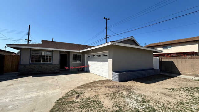
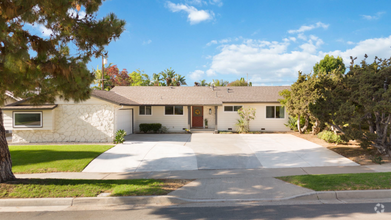
You May Also Like
Similar Rentals Nearby


What Are Walk Score®, Transit Score®, and Bike Score® Ratings?
Walk Score® measures the walkability of any address. Transit Score® measures access to public transit. Bike Score® measures the bikeability of any address.
What is a Sound Score Rating?
A Sound Score Rating aggregates noise caused by vehicle traffic, airplane traffic and local sources

17958 Nearbank Dr
Rowland Heights, CA 91748