
$900 / Month
1963 Rowan St Unit B
Philadelphia, PA 19140
2 Weeks Ago
Favorites
267-415-8815
-
Bedrooms
1
-
Bathrooms
1
-
Square Feet
600 sq ft
-
Available
Available Apr 26
1963 Rowan St

Favorites
About This Home
12 Month Lease,
$1,800 deposit,
Available Apr 26
Corner property located in the nice town section of the city, 2 blocks from Wayne junction
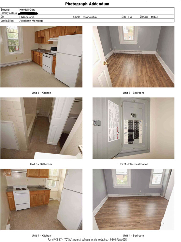
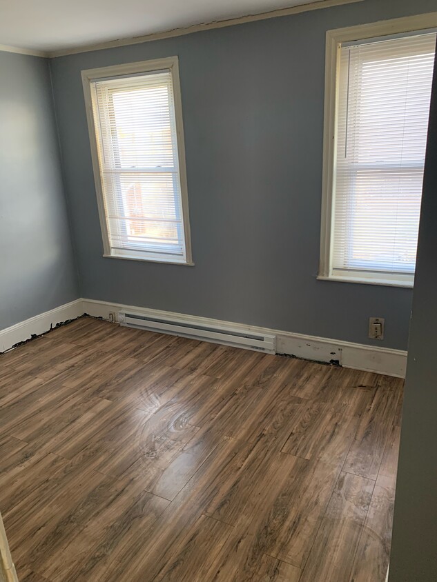
Jr. one bedroom apartment. Separate bedroom, separate kitchen, and separate bathroom
1963 Rowan St is a townhome located in Philadelphia County and the 19140 ZIP Code.
* Price shown is base rent and may not include non-optional fees and utilities.
Price, availability, fees, and any applicable rent special are subject to change without notice.
* Square footage definitions vary. Displayed square footage is approximate.
Fees and Policies
The fees below are based on community-supplied data and may exclude additional fees and utilities.
- Parking
-
Street--
Details
Utilities Included
-
Water
Property Information
-
4 units
Contact
- Listed by kendall gary
- Phone Number
- Contact
$787 / month
$129,900 Listing Price
3 Beds
•1 Baths
•
1,020 Sq Ft
$956 / month
$149,999 Listing Price
3 Beds
•1 Baths
•
1,056 Sq Ft
$826 / month
$135,000 Listing Price
4 Beds
•1 Baths
•
1,200 Sq Ft
Location
Get Directions
Living in Tioga-Nicetown provides an urban living experience near Downtown Philadelphia, which is only eight miles away. There are a variety of rental options for every budget, but the neighborhood is more affordable than other Philadelphia neighborhoods and the cost of living is relatively low. A number of styles are available including charming rowhouses and luxury apartments. Since Tioga-Nicetown is near several schools including Drexel University, Temple University, and Thomas Jefferson University, it’s a popular choice among students, faculty, and staff. The neighborhood is also home to the Lewis Katz School of Medicine at Temple University and Temple University School of Pharmacy. Residents go to locally owned restaurants and shops while community events such as festivals and health fairs heighten neighborhood pride. Along with neighborhood parks, locals enjoy getting fresh air at Fairmount Park, just three miles away.
Learn more about living in Tioga-Nicetown
Education
| Colleges & Universities | Distance | ||
|---|---|---|---|
| Colleges & Universities | Distance | ||
| Drive: | 4 min | 1.2 mi | |
| Drive: | 5 min | 1.8 mi | |
| Drive: | 5 min | 2.1 mi | |
| Drive: | 7 min | 2.8 mi |
1963 Rowan St is within 4 minutes or 1.2 miles from Temple Univ., Health Center. It is also near La Salle University and Drexel Univ., Queen Lane.
Transportation options available in Philadelphia include Hunting Park, located 0.6 mile from 1963 Rowan St. 1963 Rowan St is near Philadelphia International, located 16.3 miles or 29 minutes away, and Trenton Mercer, located 29.3 miles or 50 minutes away.
| Transit / Subway | Distance | ||
|---|---|---|---|
| Transit / Subway | Distance | ||
|
|
Walk: | 11 min | 0.6 mi |
|
|
Walk: | 17 min | 0.9 mi |
|
|
Walk: | 17 min | 0.9 mi |
|
|
Drive: | 4 min | 1.3 mi |
|
|
Drive: | 4 min | 1.4 mi |
| Commuter Rail | Distance | ||
|---|---|---|---|
| Commuter Rail | Distance | ||
|
|
Walk: | 5 min | 0.3 mi |
|
|
Drive: | 5 min | 1.7 mi |
|
|
Drive: | 5 min | 1.7 mi |
|
|
Drive: | 5 min | 2.0 mi |
|
|
Drive: | 5 min | 2.1 mi |
| Airports | Distance | ||
|---|---|---|---|
| Airports | Distance | ||
|
Philadelphia International
|
Drive: | 29 min | 16.3 mi |
|
Trenton Mercer
|
Drive: | 50 min | 29.3 mi |
Time and distance from 1963 Rowan St.
| Shopping Centers | Distance | ||
|---|---|---|---|
| Shopping Centers | Distance | ||
| Walk: | 19 min | 1.0 mi | |
| Drive: | 3 min | 1.1 mi | |
| Drive: | 5 min | 2.1 mi |
1963 Rowan St has 3 shopping centers within 2.1 miles, which is about a 5-minute walk. The miles and minutes will be for the farthest away property.
| Parks and Recreation | Distance | ||
|---|---|---|---|
| Parks and Recreation | Distance | ||
|
Awbury Arboretum
|
Drive: | 7 min | 2.9 mi |
|
Wagner Free Institute of Science
|
Drive: | 10 min | 3.2 mi |
|
Tacony Creek Park
|
Drive: | 10 min | 4.0 mi |
|
Shofuso - Japanese House and Garden
|
Drive: | 10 min | 5.1 mi |
|
Philadelphia Zoo
|
Drive: | 13 min | 6.5 mi |
1963 Rowan St has 5 parks within 6.5 miles, including Awbury Arboretum, Wagner Free Institute of Science, and Tacony Creek Park.
| Hospitals | Distance | ||
|---|---|---|---|
| Hospitals | Distance | ||
| Walk: | 20 min | 1.1 mi | |
| Drive: | 4 min | 1.2 mi | |
| Drive: | 5 min | 1.9 mi |
1963 Rowan St has 3 hospitals within 1.9 miles, the nearest is Shriners Hospitals for Children - Philadelphia which is 1.1 miles away and a 20 minute walk.
| Military Bases | Distance | ||
|---|---|---|---|
| Military Bases | Distance | ||
| Drive: | 22 min | 13.0 mi |
1963 Rowan St is 13.0 miles and a 22 minute drive from Philadelphia Naval Busi Center.
1963 Rowan St Photos
What Are Walk Score®, Transit Score®, and Bike Score® Ratings?
Walk Score® measures the walkability of any address. Transit Score® measures access to public transit. Bike Score® measures the bikeability of any address.
What is a Sound Score Rating?
A Sound Score Rating aggregates noise caused by vehicle traffic, airplane traffic and local sources
1963 Rowan St
Philadelphia, PA 19140