$3,150 / Month
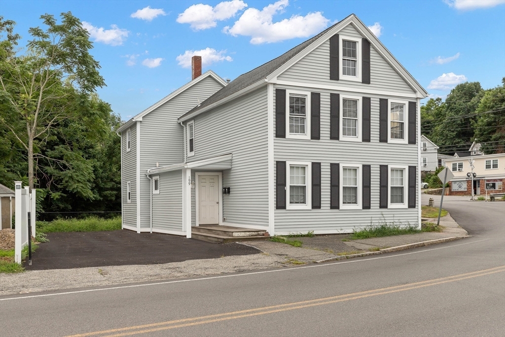
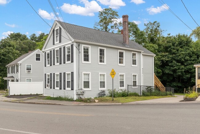
199 Andover St
Andover, MA 01810
Today
Favorites
339-970-4599
-
Bedrooms
3
-
Bathrooms
1
-
Square Feet
1,050 sq ft
-
Available
Available Now
Highlights
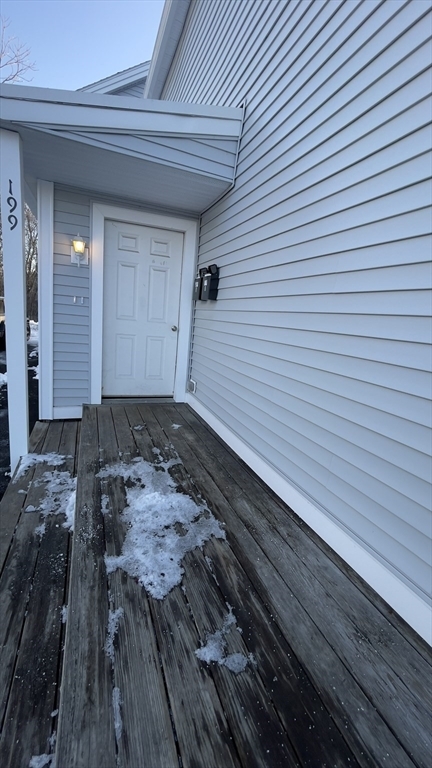
- Deck
- Fenced Yard
- No Cooling
- 1-Story Property
- Forced Air Heating System
199 Andover St Unit 1

Favorites
About This Home
$3,150 deposit,
Available Now
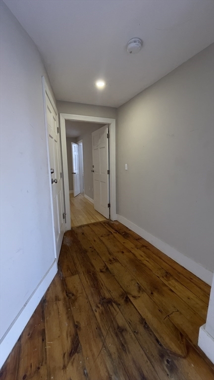
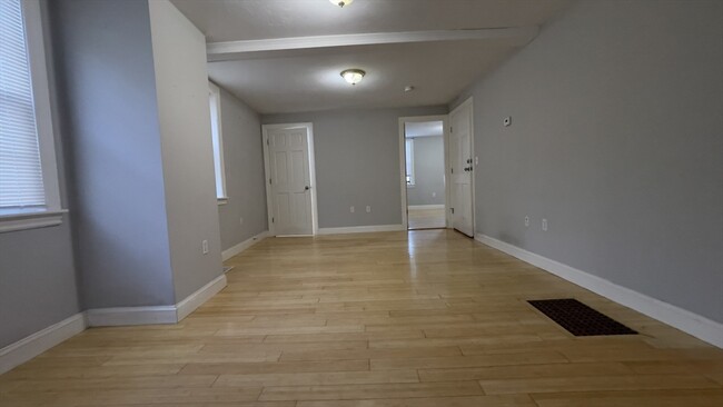
Welcome to this1st floor apartment in a 2 unit building with 3 bedrooms,a tiled newer kitchen and adjacent laundry hook up,bamboo Flooring making it easy to clean. A Short walk to Ballardvale T-Station,convenience stores,Post Office,children's playground and Shawsheen river reservation area. Highway access just a short ride to downtown restaurants/bars. Shared fenced yard. Common entry that works as great mudroom,and off street parking for 2 small cars. Basement access for tenant storage. AVAILBALE TO RENT NOW!
199 Andover St is an apartment community located in Essex County and the 01810 ZIP Code.
* Price shown is base rent and may not include non-optional fees and utilities.
Price, availability, fees, and any applicable rent special are subject to change without notice.
* Square footage definitions vary. Displayed square footage is approximate.
Home Details
Year Built
Built in 1851
Accessible Home Design
Entry on the 1st floor
Bedrooms and Bathrooms
1 Full Bathroom
3 Bedrooms
Home Design
Apartment
Interior Spaces
1-Story Property
1,050 Sq Ft Home
Kitchen
Range
Dishwasher
Laundry
Laundry on main level
Listing and Financial Details
Security Deposit $3,150
12 Month Lease Term
Assessor Parcel Number 1844462
Rent includes water, sewer, snow removal, gardener, extra storage
Lot Details
3,088 Sq Ft Lot
Fenced Yard
Fenced
Outdoor Features
Deck
Parking
2 Parking Spaces
Schools
South Elementary School
Utilities
No Cooling
Forced Air Heating System
Heating System Uses Natural Gas
Community Details
Overview
No Home Owners Association
Pet Policy
Call for details about the types of pets allowed
Contact
- Listed by Williams Kivumbi
- Phone Number (339) 970-4599
-
Source

Location
Get Directions
Amenities
- Dishwasher
- Range
- Refrigerator
- Fenced Lot
- Deck
Located about 20 miles north of Downtown Boston, Andover is a classic and historic New England gem first settled in 1642. Andover features a beautiful downtown shopping district, complete with historic architecture and cobblestone walkways. Andover extends from the Merrimack River southeast to roughly the Andover Bypass. It is home to the historic Phillips Academy, a preparatory school established in 1778, making it one of the country's oldest high schools. The oldest home in Andover, the Chandler-Bigsby-Abbot House, was built sometime before 1673.
Merrimack College sits on the east side of Andover, making the city popular with students. Other destinations include the Robert S. Peabody Museum of Archaeology, the Addison Gallery of American Art, and Indian Ridge Reservation. Harold Parker State Forest covers more than 3,300 acres across Andover, North Andover, and Reading. Outdoor activities include camping, hiking, biking, and fishing.
Learn more about living in Andover
Education
| Colleges & Universities | Distance | ||
|---|---|---|---|
| Colleges & Universities | Distance | ||
| Drive: | 9 min | 4.0 mi | |
| Drive: | 19 min | 9.1 mi | |
| Drive: | 21 min | 10.1 mi | |
| Drive: | 25 min | 11.7 mi |
199 Andover St Unit 1 is within 9 minutes or 4.0 miles from Merrimack College. It is also near Middlesex C.C., Lowell Campus and UMass Lowell.
Transportation options available in Andover include Oak Grove Station, located 15.7 miles from 199 Andover St Unit 1. 199 Andover St Unit 1 is near General Edward Lawrence Logan International, located 23.5 miles or 34 minutes away, and Manchester Boston Regional, located 32.0 miles or 48 minutes away.
| Transit / Subway | Distance | ||
|---|---|---|---|
| Transit / Subway | Distance | ||
|
|
Drive: | 24 min | 15.7 mi |
|
|
Drive: | 24 min | 17.0 mi |
| Drive: | 24 min | 17.2 mi | |
| Drive: | 25 min | 17.7 mi | |
|
|
Drive: | 29 min | 20.1 mi |
| Commuter Rail | Distance | ||
|---|---|---|---|
| Commuter Rail | Distance | ||
|
|
Walk: | 1 min | 0.1 mi |
|
|
Drive: | 6 min | 2.9 mi |
|
|
Drive: | 9 min | 4.6 mi |
|
|
Drive: | 11 min | 5.8 mi |
|
|
Drive: | 12 min | 6.4 mi |
| Airports | Distance | ||
|---|---|---|---|
| Airports | Distance | ||
|
General Edward Lawrence Logan International
|
Drive: | 34 min | 23.5 mi |
|
Manchester Boston Regional
|
Drive: | 48 min | 32.0 mi |
Time and distance from 199 Andover St Unit 1.
| Shopping Centers | Distance | ||
|---|---|---|---|
| Shopping Centers | Distance | ||
| Drive: | 7 min | 3.2 mi | |
| Drive: | 8 min | 3.8 mi | |
| Drive: | 9 min | 4.4 mi |
199 Andover St Unit 1 has 3 shopping centers within 4.4 miles, which is about a 9-minute drive. The miles and minutes will be for the farthest away property.
| Parks and Recreation | Distance | ||
|---|---|---|---|
| Parks and Recreation | Distance | ||
|
Stevens-Coolidge Place
|
Drive: | 9 min | 4.7 mi |
|
Harold Parker State Forest
|
Drive: | 15 min | 5.5 mi |
|
Lawrence Heritage State Park
|
Drive: | 12 min | 6.2 mi |
|
Smolak Farms
|
Drive: | 15 min | 7.4 mi |
|
Windrush Farm
|
Drive: | 22 min | 10.3 mi |
199 Andover St Unit 1 has 5 parks within 10.3 miles, including Stevens-Coolidge Place, Harold Parker State Forest, and Lawrence Heritage State Park.
| Hospitals | Distance | ||
|---|---|---|---|
| Hospitals | Distance | ||
| Drive: | 15 min | 7.7 mi | |
| Drive: | 23 min | 11.2 mi | |
| Drive: | 22 min | 14.6 mi |
199 Andover St Unit 1 has 3 hospitals within 14.6 miles, the nearest is Holy Family Hospital which is 7.7 miles away and a 15 minutes drive.
| Military Bases | Distance | ||
|---|---|---|---|
| Military Bases | Distance | ||
| Drive: | 29 min | 18.9 mi | |
| Drive: | 41 min | 20.3 mi | |
| Drive: | 47 min | 23.5 mi |
199 Andover St Unit 1 has 3 military bases within 23.5 miles, the nearest is Hanscom Air Force Base which is 18.9 miles away and a 29 minutes .
You May Also Like
Similar Rentals Nearby


What Are Walk Score®, Transit Score®, and Bike Score® Ratings?
Walk Score® measures the walkability of any address. Transit Score® measures access to public transit. Bike Score® measures the bikeability of any address.
What is a Sound Score Rating?
A Sound Score Rating aggregates noise caused by vehicle traffic, airplane traffic and local sources

199 Andover St
Andover, MA 01810