
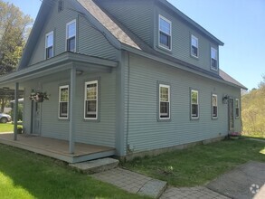
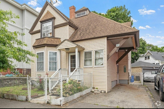
20 Priest St
20 Priest St
Hudson, MA 01749
2 Weeks Ago
Favorites
20 Priest St

Favorites
Check Back Soon for Upcoming Availability
| Beds | Baths | Average SF |
|---|---|---|
| 3 Bedrooms 3 Bedrooms 3 Br | 2 Baths 2 Baths 2 Ba | — |
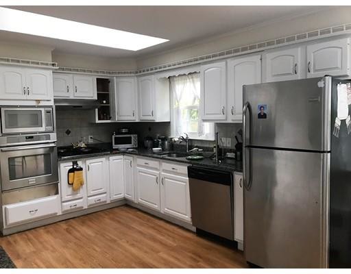
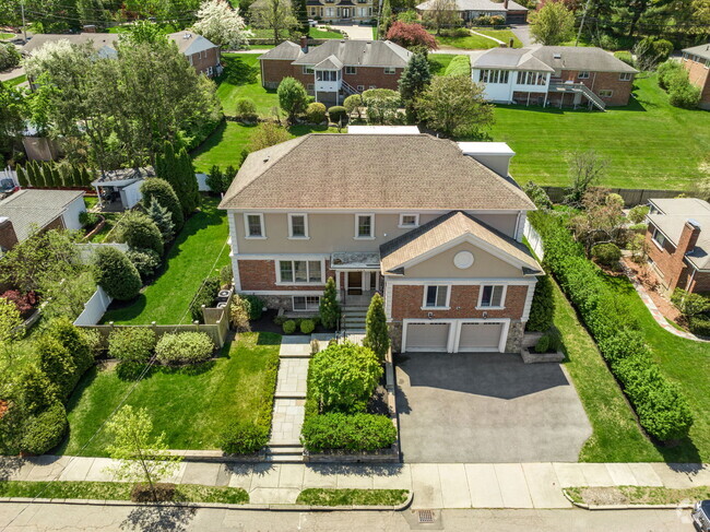
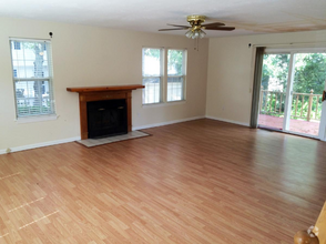
About This Property
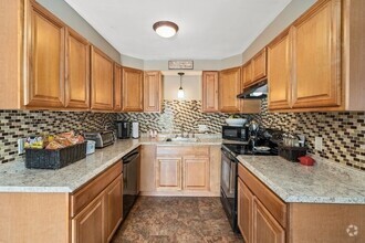
Available for November 1st, 2018 - this ranch style home is in the perfect location to take advantage of everything Hudson has to offer. Featuring 3 generous sized bedrooms; a large eat in kitchen; fenced in backyard, expansive deck, Garage, partially finished walkout basement and much, much, more. Tenant is responsible for all utilities, including water/sewer, electricity, fuel oil (natural gas), snow removal, trash removal, and all seasonal lawn care.
20 Priest St is a house located in Middlesex County and the 01749 ZIP Code.
House Features
- Fireplace
- Fenced Lot
- Deck
Fees and Policies
The fees below are based on community-supplied data and may exclude additional fees and utilities.
Pet policies are negotiable.
Location
Get Directions
Carlisle is a charming suburban community located in Middlesex County. Known for its picturesque landscapes and tight-knit community, the town offers a tranquil environment with a blend of rural and suburban living. With excellent schools and a variety of outdoor activities, Carlisle is an ideal place for renters of all lifestyles. The town also hosts numerous community events throughout the year, fostering connections among residents and enhancing the sense of belonging.
Learn more about living in CarlisleBelow are rent ranges for similar nearby apartments
Amenities
- Fireplace
- Fenced Lot
- Deck
Education
| Colleges & Universities | Distance | ||
|---|---|---|---|
| Colleges & Universities | Distance | ||
| Drive: | 24 min | 12.6 mi | |
| Drive: | 29 min | 15.6 mi | |
| Drive: | 24 min | 15.9 mi | |
| Drive: | 27 min | 18.2 mi |
20 Priest St is within 24 minutes or 12.6 miles from Framingham State College. It is also near Tufts University, Grafton and Stillman College.
Transportation options available in Hudson include Riverside Station, located 19.2 miles from 20 Priest St. 20 Priest St is near Worcester Regional, located 22.4 miles or 34 minutes away, and General Edward Lawrence Logan International, located 32.9 miles or 57 minutes away.
| Transit / Subway | Distance | ||
|---|---|---|---|
| Transit / Subway | Distance | ||
|
|
Drive: | 36 min | 19.2 mi |
|
|
Drive: | 37 min | 19.6 mi |
|
|
Drive: | 38 min | 20.3 mi |
|
|
Drive: | 40 min | 21.8 mi |
|
|
Drive: | 40 min | 22.1 mi |
| Commuter Rail | Distance | ||
|---|---|---|---|
| Commuter Rail | Distance | ||
|
|
Drive: | 18 min | 8.1 mi |
|
|
Drive: | 22 min | 10.2 mi |
|
|
Drive: | 22 min | 11.1 mi |
|
|
Drive: | 31 min | 14.0 mi |
|
|
Drive: | 23 min | 14.0 mi |
| Airports | Distance | ||
|---|---|---|---|
| Airports | Distance | ||
|
Worcester Regional
|
Drive: | 34 min | 22.4 mi |
|
General Edward Lawrence Logan International
|
Drive: | 57 min | 32.9 mi |
Time and distance from 20 Priest St.
| Shopping Centers | Distance | ||
|---|---|---|---|
| Shopping Centers | Distance | ||
| Walk: | 9 min | 0.5 mi | |
| Drive: | 3 min | 1.2 mi | |
| Drive: | 4 min | 1.8 mi |
20 Priest St has 3 shopping centers within 1.8 miles, which is about a 4-minute walk. The miles and minutes will be for the farthest away property.
| Parks and Recreation | Distance | ||
|---|---|---|---|
| Parks and Recreation | Distance | ||
|
Honey Pot Hill Orchards
|
Drive: | 7 min | 2.7 mi |
|
Memorial Forest
|
Drive: | 17 min | 6.7 mi |
|
Felton Conservation Area
|
Drive: | 13 min | 6.9 mi |
|
Gray Reservation
|
Drive: | 15 min | 7.0 mi |
|
Cedar Hill and Sawink Farm Reservation
|
Drive: | 20 min | 9.2 mi |
20 Priest St has 5 parks within 9.2 miles, including Honey Pot Hill Orchards, Memorial Forest, and Felton Conservation Area.
| Hospitals | Distance | ||
|---|---|---|---|
| Hospitals | Distance | ||
| Drive: | 8 min | 4.0 mi | |
| Drive: | 22 min | 12.0 mi | |
| Drive: | 32 min | 20.4 mi |
20 Priest St has 3 hospitals within 20.4 miles, the nearest is UMass Memorial Healthcare - Marlborough Hospital which is 4.0 miles away and a 8 minute drive.
You May Also Like
Similar Rentals Nearby
What Are Walk Score®, Transit Score®, and Bike Score® Ratings?
Walk Score® measures the walkability of any address. Transit Score® measures access to public transit. Bike Score® measures the bikeability of any address.
What is a Sound Score Rating?
A Sound Score Rating aggregates noise caused by vehicle traffic, airplane traffic and local sources
20 Priest St
Hudson, MA 01749