-
2065 Niles Ave

2065 Niles Ave
2065 Niles Ave,
Saint Paul,
MN
55116
2 Weeks Ago
Favorites
2065 Niles Ave
Favorites
No Unit Information Available for this Listing
About 2065 Niles Ave
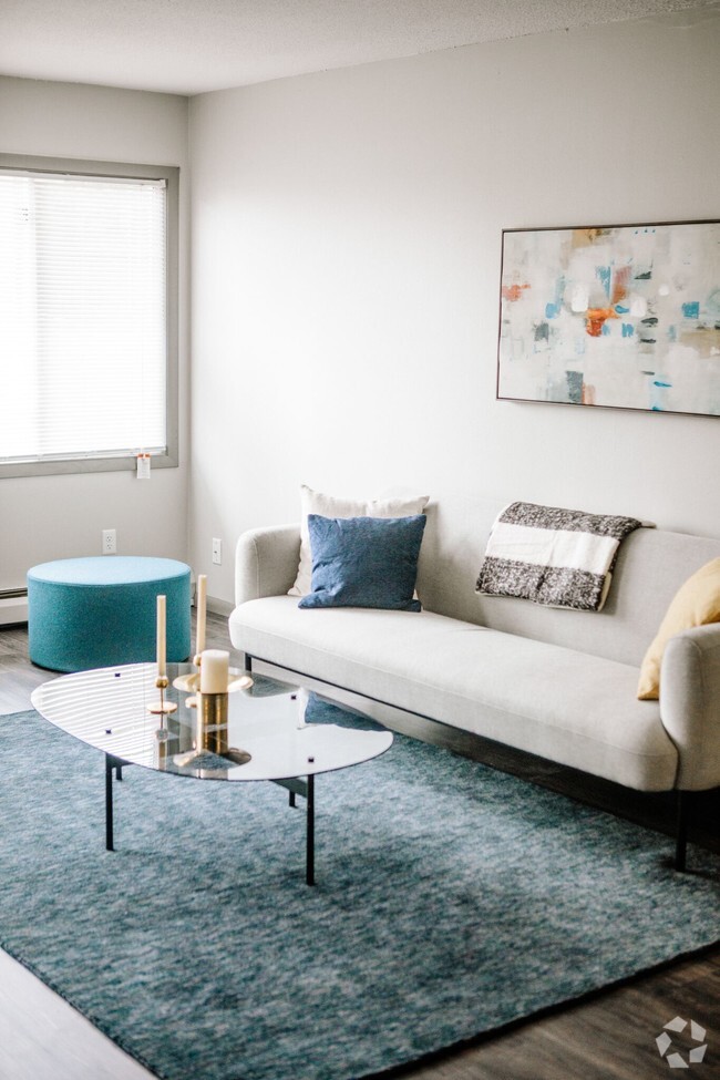
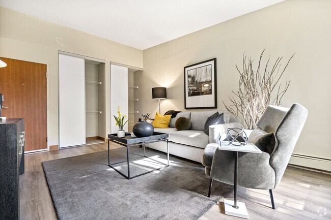
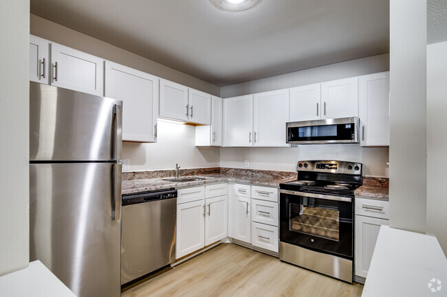
2065 Niles offers spacious 2 and 3 bedroom apartments . Great location across the street from St. Catherine's University, on the bus line! The colonial-style building is beautiful on the inside and out. It is located in the heart of the Highland Park neighborhood. This is agreat residential area with lots of peace and quiet, yet close to the fun shopping and dining options in Highland Village. The detached garages make it easy to park if you prefer not to park on the street.
2065 Niles Ave is an apartment community located in Ramsey County and the 55116 ZIP Code. This area is served by the St. Paul Public attendance zone.
Community Amenities
- Laundry Facilities
- 24 Hour Access
- Laundry Service
Apartment Features
Air Conditioning
Dishwasher
Heating
Cable Ready
- Air Conditioning
- Heating
- Cable Ready
- Dishwasher
- Kitchen
Fees and Policies
The fees below are based on community-supplied data and may exclude additional fees and utilities.
- One-Time Move-In Fees
-
Application Fee$45
Details
Lease Options
-
6, 9, 12
Property Information
-
5 units/3 stories
Location
Get Directions
Amenities
- Laundry Facilities
- 24 Hour Access
- Laundry Service
- Air Conditioning
- Heating
- Cable Ready
- Dishwasher
- Kitchen
Expenses
One-Time
Application Fee
$45
Office Hours
| Monday | By Appointment |
|---|---|
| Tuesday | By Appointment |
| Wednesday | By Appointment |
| Thursday | By Appointment |
| Friday | By Appointment |
| Saturday | By Appointment |
| Sunday | By Appointment |
The Highland community lies in the southwestern corner of Saint Paul, just 10 miles from Downtown Minneapolis. Highland is to the north of Fort Snelling, adjacent to the Mississippi River.
A 50/50 blend of commercial and residential buildings, Highland residents enjoy plentiful shopping and restaurants near their apartments. Saint Catherine University resides here, and it’s in walking distance of local eateries at the corner of Cleveland Avenue South and Ford Parkway.
A predominantly residential neighborhood, there are tons of outdoor activities to do, like improving your game at the Highland National Golf Course or picnicking at Crosby Farm Park. For easy travel, residents are comforted by their proximity to Interstate 35E and the international airport. The amusement park and aquarium at Mall of America are a short 10-minute drive from Highland.
Learn more about living in Highland
Education
| Colleges & Universities | Distance | ||
|---|---|---|---|
| Colleges & Universities | Distance | ||
| Walk: | 9 min | 0.5 mi | |
| Drive: | 3 min | 1.4 mi | |
| Drive: | 4 min | 1.9 mi | |
| Drive: | 7 min | 3.2 mi |
2065 Niles Ave is within 9 minutes or 0.5 mile from St. Catherine University. It is also near Univ. of St Thomas, St. Paul and Macalester College.
Schools


Public Elementary School
Grades PK-5
399 Students
Attendance Zone
Public Elementary School
Grades PK-5
438 Students
Nearby
Public Middle School
Grades 6-8
805 Students
Attendance Zone
Public High School
Grades 9-12
1,390 Students
Attendance Zone
Private Elementary & Middle School
Grades PK-7
183 Students
Nearby
Private Elementary & Middle School
Grades PK-8
768 Students
Nearby
Private Elementary, Middle & High School
Grades K-12
922 Students
Nearby
School data provided by
 The GreatSchools Rating helps parents compare schools within a state based on a variety of school quality indicators and provides a helpful picture of how effectively each school serves all of its students. Ratings are on a scale of 1 (below average) to 10 (above average) and can include test scores, college readiness, academic progress, advanced courses, equity, discipline and attendance data. We also advise parents to visit schools, consider other information on school performance and programs, and consider family needs as part of the school selection process.
View GreatSchools Rating Methodology
View GreatSchools Rating Methodology
Transportation options available in Saint Paul include Fairview Ave Station, located 2.7 miles from 2065 Niles Ave. 2065 Niles Ave is near Minneapolis-St Paul International/Wold-Chamberlain, located 5.2 miles or 11 minutes away.
| Transit / Subway | Distance | ||
|---|---|---|---|
| Transit / Subway | Distance | ||
| Drive: | 5 min | 2.7 mi | |
|
|
Drive: | 7 min | 2.8 mi |
|
|
Drive: | 7 min | 3.1 mi |
|
|
Drive: | 8 min | 3.3 mi |
|
|
Drive: | 9 min | 3.6 mi |
| Commuter Rail | Distance | ||
|---|---|---|---|
| Commuter Rail | Distance | ||
|
|
Drive: | 13 min | 5.9 mi |
|
|
Drive: | 17 min | 7.6 mi |
|
|
Drive: | 25 min | 16.2 mi |
|
|
Drive: | 35 min | 25.0 mi |
|
|
Drive: | 36 min | 26.7 mi |
| Airports | Distance | ||
|---|---|---|---|
| Airports | Distance | ||
|
Minneapolis-St Paul International/Wold-Chamberlain
|
Drive: | 11 min | 5.2 mi |
Time and distance from 2065 Niles Ave.
| Shopping Centers | Distance | ||
|---|---|---|---|
| Shopping Centers | Distance | ||
| Walk: | 9 min | 0.5 mi | |
| Walk: | 11 min | 0.6 mi | |
| Walk: | 13 min | 0.7 mi |
2065 Niles Ave has 3 shopping centers within 0.7 mile, which is about a 13-minute walk. The miles and minutes will be for the farthest away property.
| Parks and Recreation | Distance | ||
|---|---|---|---|
| Parks and Recreation | Distance | ||
|
Macalester College Observatory
|
Drive: | 4 min | 1.9 mi |
|
Minnehaha Park
|
Drive: | 5 min | 2.0 mi |
|
Song of Hiawatha Garden
|
Drive: | 5 min | 2.0 mi |
|
Minnehaha Falls Pergola Garden
|
Drive: | 6 min | 2.1 mi |
|
Hiawatha School Park
|
Drive: | 6 min | 2.3 mi |
2065 Niles Ave has 5 parks within 2.3 miles, including Minnehaha Falls Pergola Garden, Minnehaha Park, and Song of Hiawatha Garden.
| Hospitals | Distance | ||
|---|---|---|---|
| Hospitals | Distance | ||
| Drive: | 10 min | 4.4 mi | |
| Drive: | 10 min | 5.0 mi | |
| Drive: | 11 min | 5.2 mi |
2065 Niles Ave has 3 hospitals within 5.2 miles, the nearest is Allina United Hospital which is 4.4 miles away and a 10 minute drive.
| Military Bases | Distance | ||
|---|---|---|---|
| Military Bases | Distance | ||
| Drive: | 10 min | 4.0 mi |
2065 Niles Ave is 4.0 miles and a 10 minute drive from Fort Snelling Military Reservation.
You May Also Like
Similar Rentals Nearby


What Are Walk Score®, Transit Score®, and Bike Score® Ratings?
Walk Score® measures the walkability of any address. Transit Score® measures access to public transit. Bike Score® measures the bikeability of any address.
What is a Sound Score Rating?
A Sound Score Rating aggregates noise caused by vehicle traffic, airplane traffic and local sources
Responded To This Review