$3,200 / Month
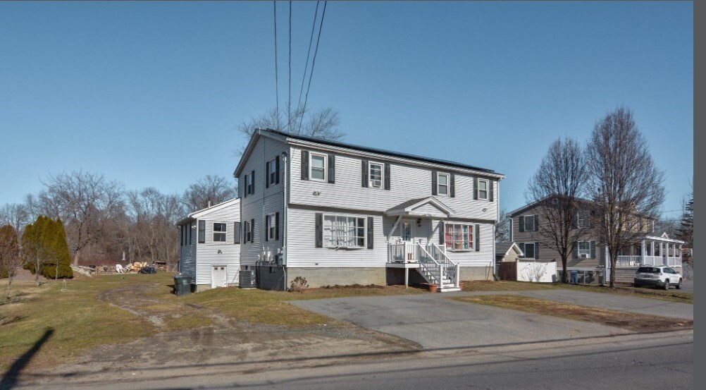
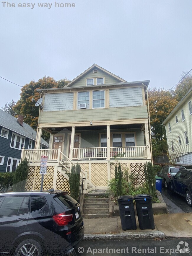
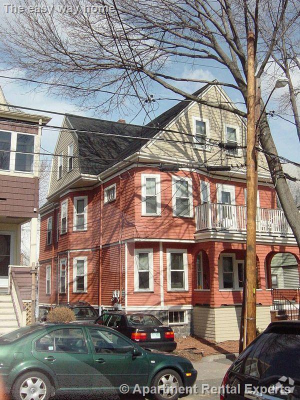
21 Hampson St
Dracut, MA 01826
Today
Favorites
781-913-4748
-
Bedrooms
4
-
Bathrooms
1.5
-
Square Feet
1,400 sq ft
-
Available
Available Now
Highlight
- Deck
21 Hampson St

Favorites
About This Home
$3,200 deposit,
Available Now
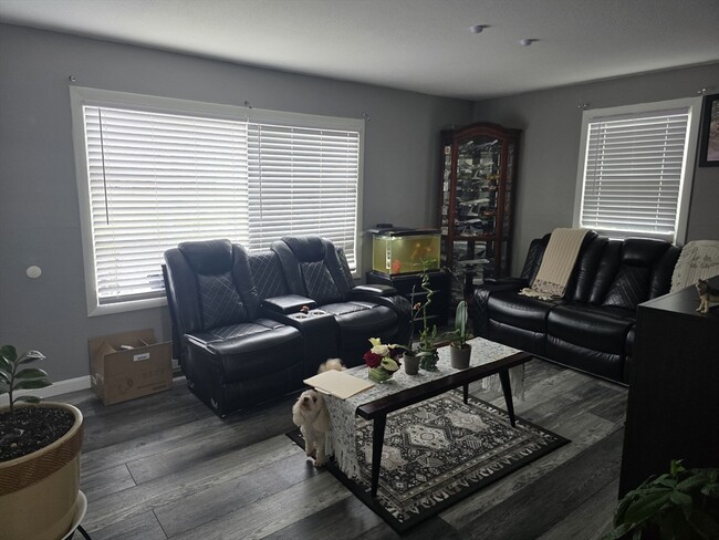
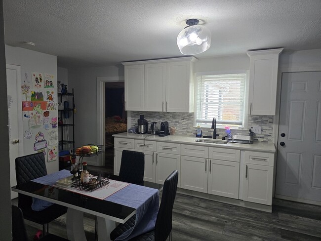
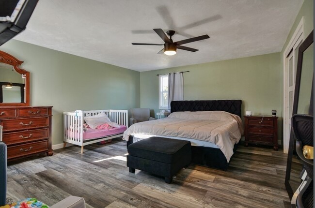
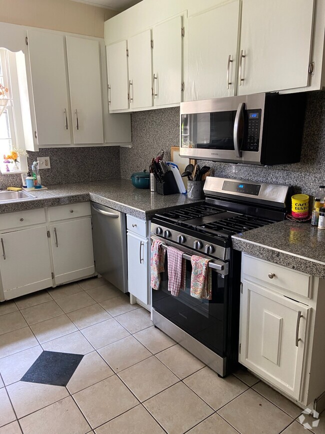
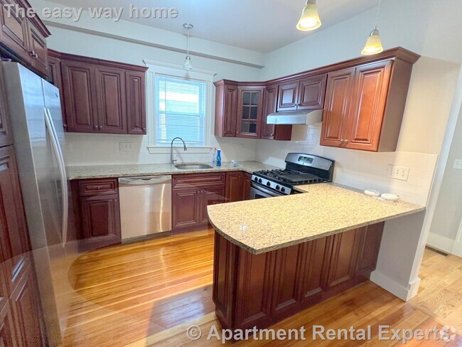
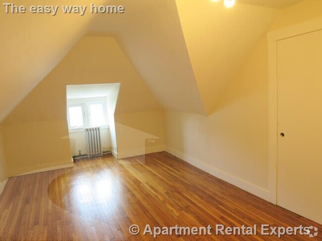
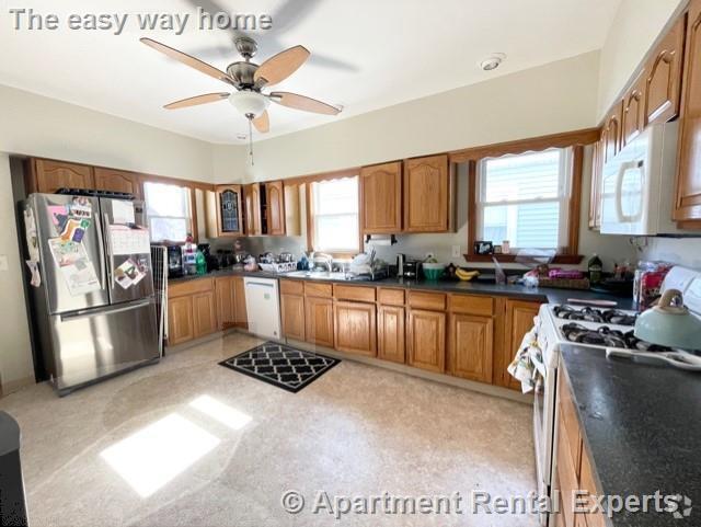
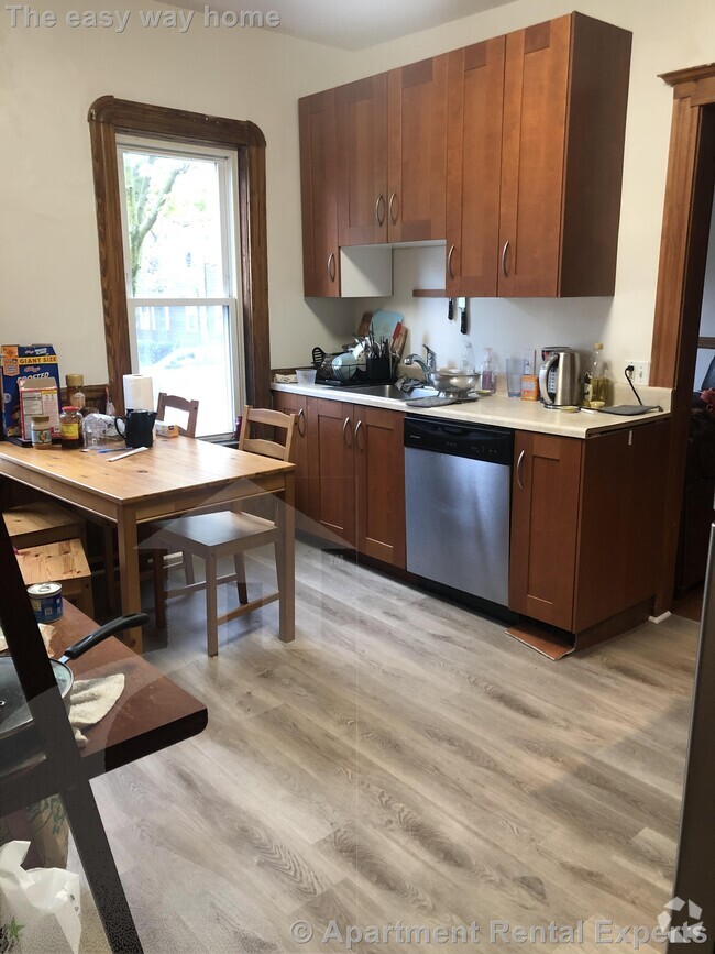
Very well-kept duplex,with 4-bedroom,living room,updated eat in kitchen. This property features hard wood floors,Central AC,deck,driveway,laundry in the basement,and sharing a large backyard.
21 Hampson St is a townhome located in Middlesex County and the 01826 ZIP Code.
* Price shown is base rent and may not include non-optional fees and utilities.
Price, availability, fees, and any applicable rent special are subject to change without notice.
* Square footage definitions vary. Displayed square footage is approximate.
Townhome Features
- Range
- Refrigerator
- Deck
Contact
- Listed by Joaquin Lemus | Keller Williams Realty Evolution
- Phone Number
-
Source
 MLS Property Information Network
The property listing data and information set forth herein were provided to MLS Property Information Network, Inc. from third party sources, including sellers, lessors and public records, and were compiled by MLS Property Information Network, Inc. The property listing data and information are for the personal, non-commercial use of consumers having a good faith interest in purchasing or leasing listed properties of the type displayed to them and may not be used for any purpose other than to identify prospective properties which such consumers may have a good faith interest in purchasing or leasing. MLS Property Information Network, Inc. and its subscribers disclaim any and all representations and warranties as to the accuracy of the property listing data and information set forth herein. All properties are subject to prior sale, change or withdrawal. Copyright © 2025 MLS Property Information Network, Inc. All rights reserved.
$3,189 / month
$499,000 Listing Price
5 Beds
•2 Baths
•
1,801 Sq Ft
$3,438 / month
$531,729 Listing Price
4 Beds
•1.5 Baths
•
1,809 Sq Ft
Location
Get Directions
Amenities
- Range
- Refrigerator
- Deck
The city of Dracut is settled on the Massachusetts-New Hampshire state line to the north and the Merrimack River to the south. This riverfront suburb offers a quaint, peaceful atmosphere with a park-like environment that you’re sure to enjoy.
Though the residential streets of Dracut are calm, once you take a leap over the Merrimack River, you’ll be in Downtown Lowell where you’ll discover historic museums, galleries, restaurants, shops, and more! Situated 32 miles northwest of Boston, Dracut is far enough from the hustle and bustle of urban living while still being in easy driving distance. Directly north of the University of Massachusetts Lowell, the city has a youthful vibe that comes from this popular university just minutes from your potential new home.
To the east, Dracut shares a portion of national state forest with its neighboring cities of Lowell and Tyngsborough.
Learn more about living in Dracut
Education
| Colleges & Universities | Distance | ||
|---|---|---|---|
| Colleges & Universities | Distance | ||
| Walk: | 19 min | 1.0 mi | |
| Drive: | 4 min | 2.0 mi | |
| Drive: | 22 min | 10.3 mi | |
| Drive: | 22 min | 11.4 mi |
21 Hampson St is within 19 minutes or 1.0 miles from UMass Lowell. It is also near Middlesex C.C., Lowell Campus and Rivier College.
Transportation options available in Dracut include Alewife Station, located 23.2 miles from 21 Hampson St. 21 Hampson St is near Manchester Boston Regional, located 29.1 miles or 45 minutes away, and General Edward Lawrence Logan International, located 32.4 miles or 49 minutes away.
| Transit / Subway | Distance | ||
|---|---|---|---|
| Transit / Subway | Distance | ||
|
|
Drive: | 38 min | 23.2 mi |
|
|
Drive: | 40 min | 23.5 mi |
| Drive: | 39 min | 23.6 mi | |
|
|
Drive: | 39 min | 24.6 mi |
|
|
Drive: | 39 min | 25.9 mi |
| Commuter Rail | Distance | ||
|---|---|---|---|
| Commuter Rail | Distance | ||
|
|
Drive: | 5 min | 2.2 mi |
|
|
Drive: | 13 min | 6.5 mi |
|
|
Drive: | 23 min | 11.0 mi |
|
|
Drive: | 21 min | 11.1 mi |
|
|
Drive: | 21 min | 13.0 mi |
| Airports | Distance | ||
|---|---|---|---|
| Airports | Distance | ||
|
Manchester Boston Regional
|
Drive: | 45 min | 29.1 mi |
|
General Edward Lawrence Logan International
|
Drive: | 49 min | 32.4 mi |
Time and distance from 21 Hampson St.
| Shopping Centers | Distance | ||
|---|---|---|---|
| Shopping Centers | Distance | ||
| Walk: | 1 min | 0.1 mi | |
| Walk: | 4 min | 0.2 mi | |
| Drive: | 4 min | 1.7 mi |
21 Hampson St has 3 shopping centers within 1.7 miles, which is about a 4-minute walk. The miles and minutes will be for the farthest away property.
| Parks and Recreation | Distance | ||
|---|---|---|---|
| Parks and Recreation | Distance | ||
|
Lowell National Historical Park
|
Drive: | 3 min | 1.8 mi |
|
Lowell Heritage State Park
|
Drive: | 5 min | 2.8 mi |
|
Lowell-Dracut-Tyngsboro State Forest
|
Drive: | 7 min | 3.3 mi |
|
The Butterfly Place
|
Drive: | 16 min | 8.3 mi |
|
Great Brook Farm State Park
|
Drive: | 17 min | 8.8 mi |
21 Hampson St has 5 parks within 8.8 miles, including Lowell National Historical Park, Lowell-Dracut-Tyngsboro State Forest, and Lowell Heritage State Park.
| Hospitals | Distance | ||
|---|---|---|---|
| Hospitals | Distance | ||
| Drive: | 2 min | 1.6 mi | |
| Drive: | 19 min | 10.5 mi | |
| Drive: | 24 min | 11.3 mi |
21 Hampson St has 3 hospitals within 11.3 miles, the nearest is Lowell General Hospital which is 1.6 miles away and a 2 minute drive.
| Military Bases | Distance | ||
|---|---|---|---|
| Military Bases | Distance | ||
| Drive: | 29 min | 16.8 mi |
21 Hampson St is 16.8 miles and a 29 minute drive from Hanscom Air Force Base.
You May Also Like
Similar Rentals Nearby


What Are Walk Score®, Transit Score®, and Bike Score® Ratings?
Walk Score® measures the walkability of any address. Transit Score® measures access to public transit. Bike Score® measures the bikeability of any address.
What is a Sound Score Rating?
A Sound Score Rating aggregates noise caused by vehicle traffic, airplane traffic and local sources

21 Hampson St
Dracut, MA 01826