
$3,800 / Month
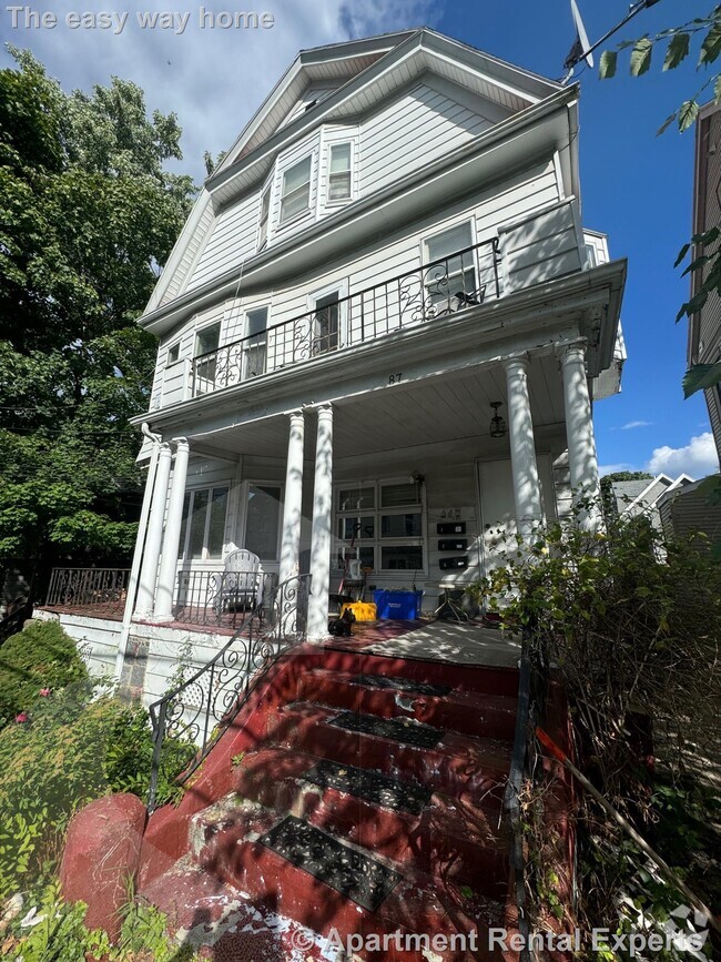
21 Howard St
Cambridge, MA 02139
Today
Favorites
617-487-4868
-
Bedrooms
2
-
Bathrooms
2
-
Square Feet
670 sq ft
-
Available
Available Sep 1
21 Howard St

Favorites
About This Home
$3,800 deposit,
Available Sep 1
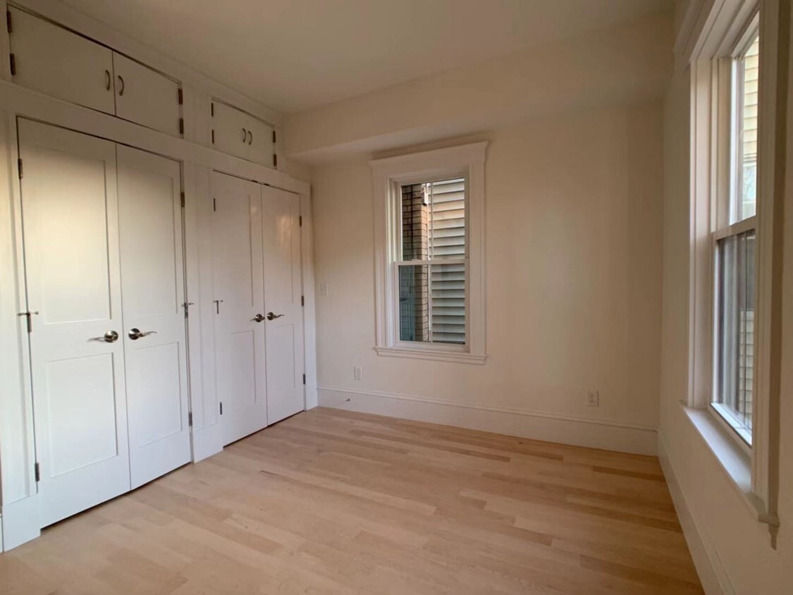
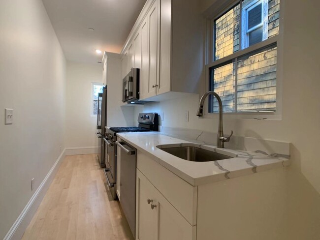
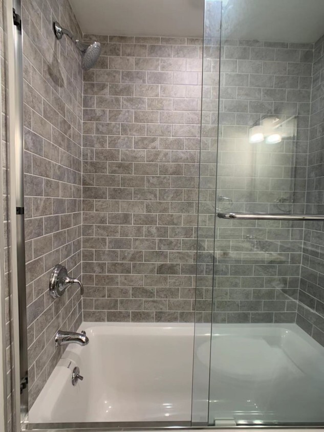
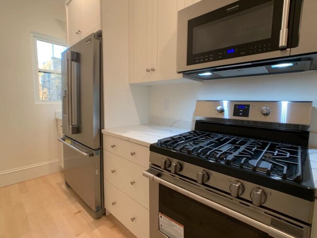
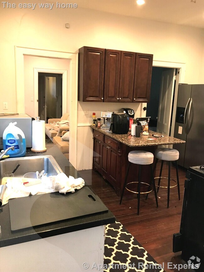
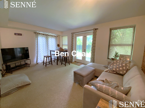
Recently renovated 2 bedrooms 2 bathroom with quality finishes! Be the first to live in this open concept living/dining room with in-unit laundry, central cooling/heating system, and private balcony. Quartz countertop and stainless steel appliances. Minutes to Central Square/Red Line MBTA station, the Charles River. Enjoy all the retail and restaurants in Central square, everything within blocks!
21 Howard St is a townhome located in Middlesex County and the 02139 ZIP Code. This area is served by the Cambridge attendance zone.
* Price shown is base rent and may not include non-optional fees and utilities.
Price, availability, fees, and any applicable rent special are subject to change without notice.
* Square footage definitions vary. Displayed square footage is approximate.
Contact
- Listed by Green Ocean Property Management
- Phone Number (617) 487-4868
- Contact
$3,885 / month
$599,000 Listing Price
2 Beds
•2 Baths
•
1,046 Sq Ft
$4,065 / month
$575,000 Listing Price
4 Beds
•2.5 Baths
•
1,404 Sq Ft
$3,433 / month
$549,000 Listing Price
5 Beds
•2 Baths
•
1,801 Sq Ft
Location
Get Directions
As one of the top-ranking neighborhoods to live in in the city of Cambridge, Riverside is a premier spot for waterfront views, outdoor recreation, and a happening nightlife scene. Large, colorful homes and historic buildings mark this neighborhood with local charm that you won’t want to miss. Exuding a college-town vibe, Riverside is situated directly south of Harvard University, so though the neighborhood feels family-friendly, it’s also very youthful due to the proximity to this prestigious university.
But Harvard isn’t the only school in walking distance of Riverside. Massachusetts Institute of Technology (known as MIT) is just two miles from Riverside, making this neighborhood an educational hub. Whether you want to walk, drive, or make use of public transit, by bus or subway, this area is very commuter-friendly.
Learn more about living in Riverside
Education
| Colleges & Universities | Distance | ||
|---|---|---|---|
| Colleges & Universities | Distance | ||
| Walk: | 6 min | 0.3 mi | |
| Drive: | 3 min | 1.1 mi | |
| Drive: | 2 min | 1.2 mi | |
| Drive: | 3 min | 1.6 mi |
21 Howard St is within 6 minutes or 0.3 mile from Cambridge College. It is also near Harvard University and MIT.
Schools
Public Elementary & Middle School
Grades PK-8
407 Students
Attendance Zone
7
Out of 10
Public Elementary School
Grades PK-5
332 Students
Attendance Zone
8
Out of 10
Public Middle School
Grades 6-8
251 Students
Attendance Zone
8
Out of 10
Public Middle School
Grades 6-8
293 Students
Attendance Zone
4
Out of 10
Public High School
Grades 9-12
1,867 Students
Attendance Zone
6
Out of 10
Private Elementary School
Grades PK-K
51 Students
Nearby
Private Elementary & Middle School
Grades 4-8
28 Students
Nearby
Private Middle & High School
Grades 8-12
29 Students
Nearby
Private Middle & High School
Grades 7-12
Nearby
School data provided by
GreatSchools
The GreatSchools Rating helps parents compare schools within a state based on a variety of school quality indicators and provides a helpful picture of how effectively each school serves all of its students. Ratings are on a scale of 1 (below average) to 10 (above average) and can include test scores, college readiness, academic progress, advanced courses, equity, discipline and attendance data. We also advise parents to visit schools, consider other information on school performance and programs, and consider family needs as part of the school selection process.
Transportation options available in Cambridge include Central Square Station, located 0.4 mile from 21 Howard St. 21 Howard St is near General Edward Lawrence Logan International, located 8.2 miles or 14 minutes away.
| Transit / Subway | Distance | ||
|---|---|---|---|
| Transit / Subway | Distance | ||
|
|
Walk: | 8 min | 0.4 mi |
|
|
Drive: | 2 min | 1.1 mi |
|
|
Drive: | 4 min | 1.6 mi |
|
|
Drive: | 4 min | 1.7 mi |
|
|
Drive: | 5 min | 1.9 mi |
| Commuter Rail | Distance | ||
|---|---|---|---|
| Commuter Rail | Distance | ||
|
|
Drive: | 4 min | 2.1 mi |
|
|
Drive: | 4 min | 2.3 mi |
|
|
Drive: | 7 min | 3.1 mi |
|
|
Drive: | 10 min | 4.1 mi |
| Drive: | 12 min | 6.9 mi |
| Airports | Distance | ||
|---|---|---|---|
| Airports | Distance | ||
|
General Edward Lawrence Logan International
|
Drive: | 14 min | 8.2 mi |
Time and distance from 21 Howard St.
| Shopping Centers | Distance | ||
|---|---|---|---|
| Shopping Centers | Distance | ||
| Walk: | 6 min | 0.3 mi | |
| Walk: | 12 min | 0.6 mi | |
| Walk: | 12 min | 0.6 mi |
21 Howard St has 3 shopping centers within 0.6 mile, which is about a 12-minute walk. The miles and minutes will be for the farthest away property.
| Parks and Recreation | Distance | ||
|---|---|---|---|
| Parks and Recreation | Distance | ||
|
Longfellow National Historic Site
|
Drive: | 4 min | 1.6 mi |
|
Mineralogical and Geological Museum
|
Drive: | 4 min | 1.8 mi |
|
Harvard Museum of Natural History
|
Drive: | 4 min | 1.8 mi |
|
Coit Observatory
|
Drive: | 4 min | 2.0 mi |
|
Charles River Reservation
|
Drive: | 7 min | 3.3 mi |
21 Howard St has 5 parks within 3.3 miles, including Harvard Museum of Natural History, Mineralogical and Geological Museum, and Coit Observatory.
| Hospitals | Distance | ||
|---|---|---|---|
| Hospitals | Distance | ||
| Walk: | 16 min | 0.9 mi | |
| Drive: | 4 min | 1.7 mi | |
| Drive: | 5 min | 2.0 mi |
21 Howard St has 3 hospitals within 2.0 miles, the nearest is Cambridge Health Alliance which is 0.9 mile away and a 16 minute walk.
| Military Bases | Distance | ||
|---|---|---|---|
| Military Bases | Distance | ||
| Drive: | 24 min | 13.0 mi | |
| Drive: | 27 min | 16.1 mi |
21 Howard St is 13.0 miles from Hanscom Air Force Base, and is convenient to other military bases, including US Military Reservation.
You May Also Like
Similar Rentals Nearby
-
-
-
-
-
 $3,1003 Beds, 1 Bath, 1,277 sq ftTownhome for Rent
 -
 $4,2003 Beds, 2 Baths, 1,133 sq ftTownhome for Rent
 -
 $6,0005 Beds, 1 Bath, 1,855 sq ftTownhome for Rent
 -
 $7,9955 Beds, 5.5 Baths, 1,999 sq ftTownhome for Rent
 -
-
 $3,5002 Beds, 1.5 Baths, 913 sq ftTownhome for Rent


What Are Walk Score®, Transit Score®, and Bike Score® Ratings?
Walk Score® measures the walkability of any address. Transit Score® measures access to public transit. Bike Score® measures the bikeability of any address.
What is a Sound Score Rating?
A Sound Score Rating aggregates noise caused by vehicle traffic, airplane traffic and local sources

21 Howard St
Cambridge, MA 02139