
$1,995 / Month
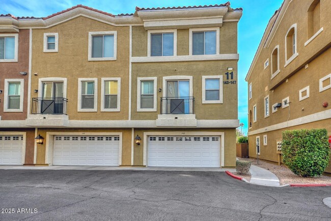
22125 N 29th Ave
Phoenix, AZ 85027
Today
Favorites
623-640-8651
-
Bedrooms
2
-
Bathrooms
3
-
Square Feet
1,322 sq ft
-
Available
Available Now
Highlights
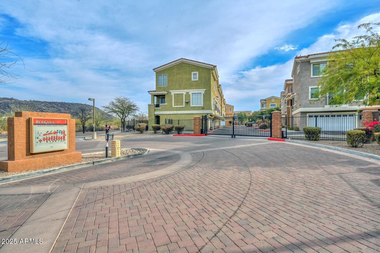
- Gated Community
- Mountain View
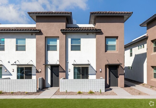
- Contemporary Architecture
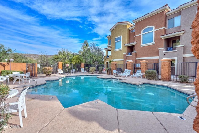
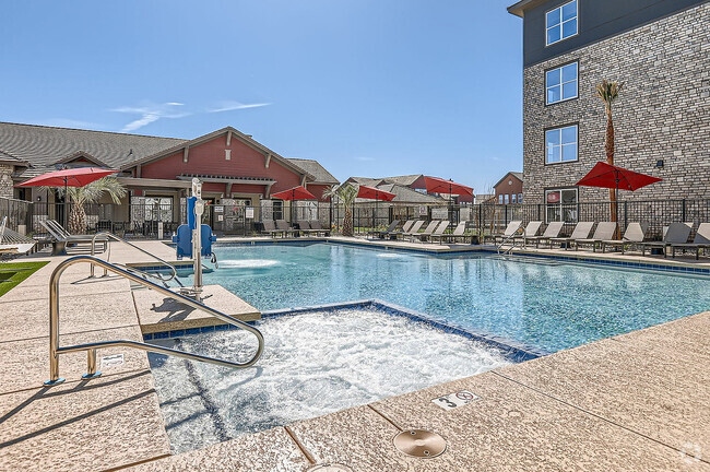
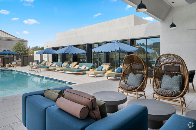
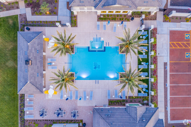
- Community Pool
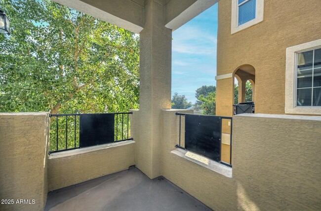
- Balcony
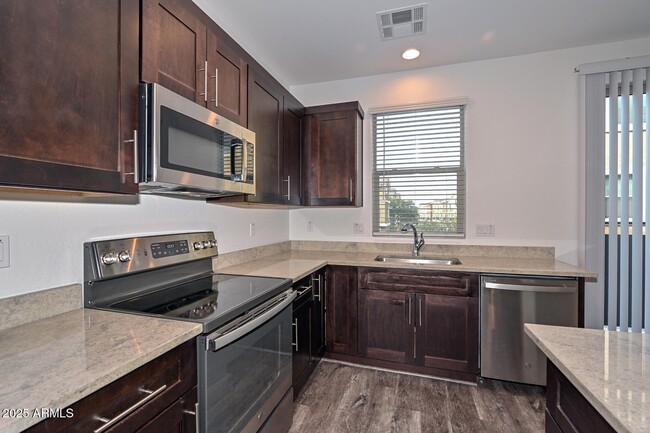
- Eat-In Kitchen
22125 N 29th Ave

Favorites
About This Home
$2,195 deposit,
Available Now
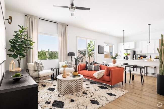
Move-in Ready Spacious 1,322 sf,2-bed,2.5 bath with attached 2 car garage in North Phoenix Gated Adobe Mountain Community. Kitchen has Granite countertops and island,stainless steel refrigerator,microwave and stove. Separate pantry,Covered Balcony. Both Bedrooms upstairs,Primary has a walk-in closet and en-suite with double sinks. The 2nd bedroom has its own full bath nearby. Upstairs laundry with Full size Washer and Dryer. Community Pool with Mountain Views. Built in 2020,this home is Just off the 1-17 and 101 and easy access to the 303 and entire Valley. Close to the Chip Plant,Phoenix Deer Valley Airport,HonorHealth Deer Valley Medical Center,Costco and the Shops at Norterra. Public transportation is available nearby. Ready Now!
22125 N 29th Ave is a townhome located in Maricopa County and the 85027 ZIP Code. This area is served by the Deer Valley Unified District attendance zone.
* Price shown is base rent and may not include non-optional fees and utilities.
Price, availability, fees, and any applicable rent special are subject to change without notice.
* Square footage definitions vary. Displayed square footage is approximate.
Home Details
Home Type
Townhome
Year Built
Built in 2020
Bedrooms and Bathrooms
Primary Bathroom is a Full Bathroom
Dual Vanity Sinks in Primary Bathroom
2.5 Bathrooms
2 Bedrooms
Flooring
Carpet
Laminate
Home Design
Contemporary Architecture
Tile Roof
Stucco
Wood Frame Construction
Home Security
Fire Sprinkler System
Interior Spaces
Double Pane Windows
Ceiling height of 9 feet or more
Ceiling Fan
1,322 Sq Ft Home
3-Story Property
Low Emissivity Windows
Vinyl Clad Windows
Kitchen
Eat-In Kitchen
Kitchen Island
Built-In Microwave
Laundry
Stacked Washer and Dryer
Laundry on upper level
Listing and Financial Details
Property Available on 1/1/25
12-Month Minimum Lease Term
Tax Lot 23
Assessor Parcel Number 206-04-543
Location
Property is near a bus stop
Lot Details
957 Sq Ft Lot
Wrought Iron Fence
Block Wall Fence
Outdoor Features
Balcony
Parking
2 Car Garage
Unassigned Parking
Garage Door Opener
Schools
Paseo Hills Elementary School
Deer Valley Middle School
Barry Goldwater High School
Utilities
Refrigerated Cooling System
Water Softener
High Speed Internet
Heating Available
Cable TV Available
Views
Mountain Views
Community Details
Overview
Property has a Home Owners Association
Hoamco Association, Phone Number (800) 447-3838
Built by Taylor Morgan Homes LLC
Berkana At Adobe Mountain Condominium Subdivision, Cliffrose Floorplan
Recreation
Community Pool
Security
Gated Community
Contact
- Listed by Shirley Giles | Realty Executives
- Phone Number
- Contact
-
Source
Arizona Regional MLS
Copyright 2025 Arizona Regional MLS. All rights reserved. Information is deemed reliable but not guaranteed.
Location
Get Directions
Deer Valley is a family-friendly suburb and residential neighborhood that’s constantly evolving. There are abundant outdoor recreational opportunities in Deer Valley because of its proximity to several natural attractions like Deem Hills and Cave Buttes, both known for scenic hiking and mountain biking trails. Residents have easy access to abundant shopping opportunities without having to leave town at places like Deer Valley Towne Center and Bell Towne Plaza. Deer Valley is home to good public schools and is the ideal suburb for those commuting to Downtown Phoenix and beyond, located less than 20 miles south of town along Interstate 17.
Learn more about living in Deer Valley
Education
| Colleges & Universities | Distance | ||
|---|---|---|---|
| Colleges & Universities | Distance | ||
| Drive: | 12 min | 5.6 mi | |
| Drive: | 12 min | 6.1 mi | |
| Drive: | 15 min | 8.5 mi | |
| Drive: | 17 min | 8.6 mi |
22125 N 29th Ave is within 12 minutes or 5.6 miles from Midwestern University. It is also near Glendale C.C., North Campus and Arizona State University, West.
Schools

Public Elementary & Middle School
Grades PK-8
743 Students
Attendance Zone
Public Middle & High School
Grades 7-12
1,641 Students
Attendance Zone
Private Elementary & Middle School
Grades PK-8
Nearby
Private Middle & High School
Grades 6-12
Nearby
School data provided by
 The GreatSchools Rating helps parents compare schools within a state based on a variety of school quality indicators and provides a helpful picture of how effectively each school serves all of its students. Ratings are on a scale of 1 (below average) to 10 (above average) and can include test scores, college readiness, academic progress, advanced courses, equity, discipline and attendance data. We also advise parents to visit schools, consider other information on school performance and programs, and consider family needs as part of the school selection process.
View GreatSchools Rating Methodology
View GreatSchools Rating Methodology
Transportation options available in Phoenix include 19Th Ave/Dunlap, located 9.8 miles from 22125 N 29th Ave. 22125 N 29th Ave is near Phoenix Sky Harbor International, located 24.1 miles or 34 minutes away.
| Transit / Subway | Distance | ||
|---|---|---|---|
| Transit / Subway | Distance | ||
|
|
Drive: | 15 min | 9.8 mi |
|
|
Drive: | 16 min | 10.8 mi |
|
|
Drive: | 16 min | 11.5 mi |
|
|
Drive: | 18 min | 12.6 mi |
|
|
Drive: | 20 min | 13.8 mi |
| Airports | Distance | ||
|---|---|---|---|
| Airports | Distance | ||
|
Phoenix Sky Harbor International
|
Drive: | 34 min | 24.1 mi |
Time and distance from 22125 N 29th Ave.
| Shopping Centers | Distance | ||
|---|---|---|---|
| Shopping Centers | Distance | ||
| Drive: | 3 min | 1.2 mi | |
| Drive: | 3 min | 1.2 mi | |
| Drive: | 3 min | 1.3 mi |
22125 N 29th Ave has 3 shopping centers within 1.3 miles, which is about a 3-minute drive. The miles and minutes will be for the farthest away property.
| Parks and Recreation | Distance | ||
|---|---|---|---|
| Parks and Recreation | Distance | ||
|
Adobe Mountain Park
|
Drive: | 3 min | 1.1 mi |
|
Paseo Highlands Park
|
Drive: | 4 min | 2.2 mi |
|
Adobe Dam Regional Park
|
Drive: | 6 min | 3.1 mi |
|
Conocido Park
|
Drive: | 7 min | 4.3 mi |
|
Turtle Rock Basin
|
Drive: | 12 min | 6.2 mi |
22125 N 29th Ave has 5 parks within 6.2 miles, including Adobe Mountain Park, Paseo Highlands Park, and Adobe Dam Regional Park.
| Hospitals | Distance | ||
|---|---|---|---|
| Hospitals | Distance | ||
| Walk: | 18 min | 0.9 mi | |
| Drive: | 4 min | 1.7 mi | |
| Drive: | 12 min | 7.2 mi |
22125 N 29th Ave has 3 hospitals within 7.2 miles, the nearest is Quail Run Behavioral Health which is 0.9 mile away and a 18 minute walk.
| Military Bases | Distance | ||
|---|---|---|---|
| Military Bases | Distance | ||
| Drive: | 30 min | 21.7 mi | |
| Drive: | 35 min | 24.0 mi | |
| Drive: | 111 min | 84.7 mi |
22125 N 29th Ave has 3 military bases within 84.7 miles, the nearest is Luke Air Force Base which is 21.7 miles away and a 30 minute drive.
You May Also Like
Similar Rentals Nearby
-
-
-
-
-
1 / 16
-
-
-
-
-


What Are Walk Score®, Transit Score®, and Bike Score® Ratings?
Walk Score® measures the walkability of any address. Transit Score® measures access to public transit. Bike Score® measures the bikeability of any address.
What is a Sound Score Rating?
A Sound Score Rating aggregates noise caused by vehicle traffic, airplane traffic and local sources
22125 N 29th Ave
Phoenix, AZ 85027