

$3,600 / Month
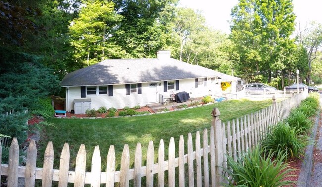
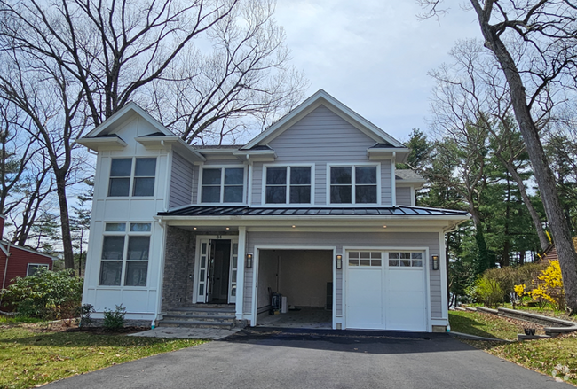
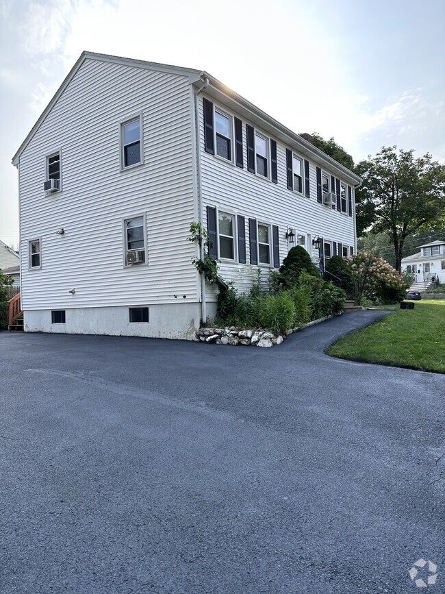
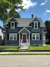
23 Oneil Dr
Westborough, MA 01581
2 Weeks Ago
Favorites
23 Oneil Dr

Favorites
Check Back Soon for Upcoming Availability
| Beds | Baths | Average SF |
|---|---|---|
| 4 Bedrooms 4 Bedrooms 4 Br | 2 Baths 2 Baths 2 Ba | 2,200 SF |
About This Property
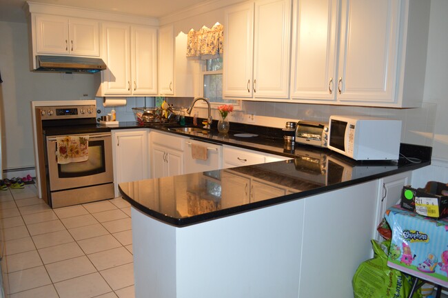
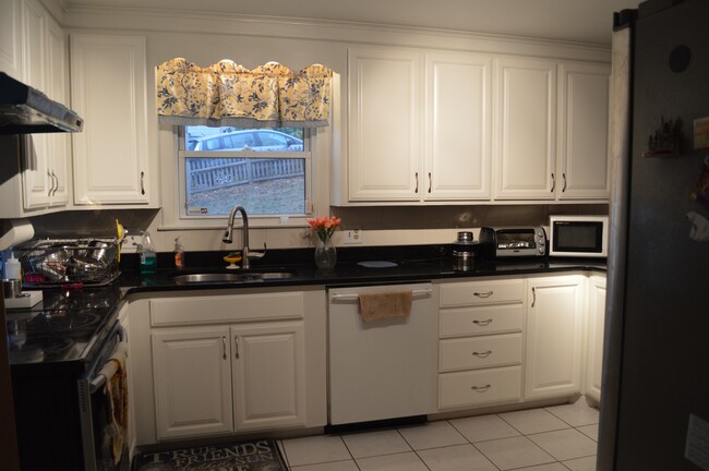
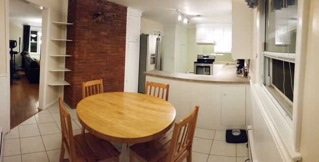
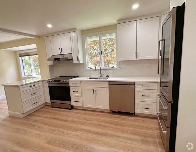
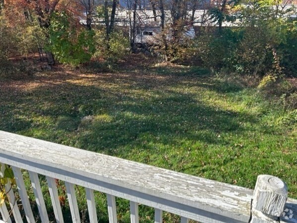
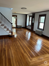
OPEN HOUSE ON 1/13/2023, FRIDAY, 6:00 PM TO 8:00 PM. Beautiful single family home features updated kitchen with granite counter top, living room, family room, breakfast nook, 4 bedrooms, 2 full bathrooms, a bonus room, and an office den. There is a one-car garage, four-car parking on the driveway, and plenty of street parking. It is located at the heart of Westborough, next to the high school, walk to the library, town center, and Bay State Common featuring Roche Bros and Penera Bread. O’neil Drive is THE walking and jogging route for the town. While you can enjoy conversations with neighbors and walkers on the front yard, there is plenty of privacy on the deck and in the back yard, which was surrounded by woods. Nearby shopping includes Wegman’s, BJ’s, Target, etc. It is within 20 minutes’ drive to all major hospitals, including UMass Memorial University Campus and 5 minutes’ drive to the Commuter Rail. Easy access to Route 9, I-495, and I-90.
23 Oneil Dr is a house located in Worcester County and the 01581 ZIP Code.
House Features
Washer/Dryer
Air Conditioning
Dishwasher
Granite Countertops
- Washer/Dryer
- Air Conditioning
- Smoke Free
- Fireplace
- Dishwasher
- Granite Countertops
- Kitchen
- Breakfast Nook
- Family Room
- Office
- Den
- Deck
- Yard
Fees and Policies
The fees below are based on community-supplied data and may exclude additional fees and utilities.
- Parking
-
Garage--
Details
Utilities Included
-
Water
-
Sewer
Location
Get Directions
Situated just moments east of Worcester is the Route 9 Corridor, a large neighborhood compiled of several communities including Shrewsbury, Westborough, Northborough, and Southborough. Not only is Worcester at residents’ fingertips, but Downtown Boston is less than 40 miles east. The Route 9 Corridor is a commuter’s dream, offering easy city access and entry onto Interstates 290, 495, and 90.
The suburb is dotted with ponds, reservoirs, brooks, and rivers, providing ample outdoor recreation. Renters craving a beach day can bask on the sunny shores of Lake Chauncy Beach. Route 9 Corridor’s Prospect Park allows locals to take their dog for a stroll while Assabet Park gives children ample space to play on the playground. Those looking for winter recreation won’t want to miss the powdery slopes of Ski Ward Ski Area. No matter the season, renters settling in this diverse community can choose from gorgeous apartments ranging in price and amenities.
Learn more about living in Route 9 CorridorBelow are rent ranges for similar nearby apartments
| Beds | Average Size | Lowest | Typical | Premium |
|---|---|---|---|---|
| Studio Studio Studio | 506 Sq Ft | $1,857 | $2,454 | $4,000 |
| 1 Bed 1 Bed 1 Bed | 798 Sq Ft | $1,200 | $2,932 | $7,150 |
| 2 Beds 2 Beds 2 Beds | 1147-1148 Sq Ft | $1,975 | $3,646 | $6,805 |
| 3 Beds 3 Beds 3 Beds | 1496 Sq Ft | $2,200 | $4,649 | $10,807 |
| 4 Beds 4 Beds 4 Beds | 2219 Sq Ft | $3,075 | $4,405 | $5,000 |
Amenities
- Washer/Dryer
- Air Conditioning
- Smoke Free
- Fireplace
- Dishwasher
- Granite Countertops
- Kitchen
- Breakfast Nook
- Family Room
- Office
- Den
- Deck
- Yard
Expenses
Utilities Included
Water, Sewer
Included
Education
| Colleges & Universities | Distance | ||
|---|---|---|---|
| Colleges & Universities | Distance | ||
| Drive: | 9 min | 4.0 mi | |
| Drive: | 16 min | 8.9 mi | |
| Drive: | 19 min | 10.8 mi | |
| Drive: | 20 min | 11.1 mi |
23 Oneil Dr is within 9 minutes or 4.0 miles from Tufts University, Grafton. It is also near Stillman College and Worcester Polytechnic Inst..
Transportation options available in Westborough include Riverside Station, located 22.7 miles from 23 Oneil Dr. 23 Oneil Dr is near Worcester Regional, located 15.7 miles or 30 minutes away, and General Edward Lawrence Logan International, located 35.8 miles or 52 minutes away.
| Transit / Subway | Distance | ||
|---|---|---|---|
| Transit / Subway | Distance | ||
|
|
Drive: | 35 min | 22.7 mi |
|
|
Drive: | 35 min | 23.0 mi |
|
|
Drive: | 36 min | 23.7 mi |
|
|
Drive: | 39 min | 25.3 mi |
|
|
Drive: | 39 min | 25.5 mi |
| Commuter Rail | Distance | ||
|---|---|---|---|
| Commuter Rail | Distance | ||
|
|
Drive: | 6 min | 2.4 mi |
|
|
Drive: | 9 min | 4.1 mi |
|
|
Drive: | 15 min | 7.6 mi |
|
|
Drive: | 19 min | 10.4 mi |
|
|
Drive: | 25 min | 11.1 mi |
| Airports | Distance | ||
|---|---|---|---|
| Airports | Distance | ||
|
Worcester Regional
|
Drive: | 30 min | 15.7 mi |
|
General Edward Lawrence Logan International
|
Drive: | 52 min | 35.8 mi |
Time and distance from 23 Oneil Dr.
| Shopping Centers | Distance | ||
|---|---|---|---|
| Shopping Centers | Distance | ||
| Walk: | 19 min | 1.0 mi | |
| Drive: | 6 min | 1.9 mi | |
| Drive: | 6 min | 2.0 mi |
23 Oneil Dr has 3 shopping centers within 2.0 miles, which is about a 6-minute walk. The miles and minutes will be for the farthest away property.
| Parks and Recreation | Distance | ||
|---|---|---|---|
| Parks and Recreation | Distance | ||
|
Cedar Hill and Sawink Farm Reservation
|
Drive: | 10 min | 3.8 mi |
|
Walkup And Robinson Memorial Reservation
|
Drive: | 9 min | 3.9 mi |
|
Whitehall State Park
|
Drive: | 14 min | 4.7 mi |
|
Ward Hill Ski Area
|
Drive: | 13 min | 5.7 mi |
|
Upton State Forest
|
Drive: | 13 min | 6.0 mi |
23 Oneil Dr has 5 parks within 6.0 miles, including Walkup And Robinson Memorial Reservation, Cedar Hill and Sawink Farm Reservation, and Whitehall State Park.
| Hospitals | Distance | ||
|---|---|---|---|
| Hospitals | Distance | ||
| Drive: | 15 min | 8.6 mi | |
| Drive: | 16 min | 8.9 mi | |
| Drive: | 17 min | 9.9 mi |
23 Oneil Dr has 3 hospitals within 9.9 miles, the nearest is Worcester Recovery Center and Hospital which is 8.6 miles away and a 15 minute drive.
| Military Bases | Distance | ||
|---|---|---|---|
| Military Bases | Distance | ||
| Drive: | 28 min | 15.6 mi |
23 Oneil Dr is 15.6 miles and a 28 minute drive from US Military Reservation.
You May Also Like
Similar Rentals Nearby
What Are Walk Score®, Transit Score®, and Bike Score® Ratings?
Walk Score® measures the walkability of any address. Transit Score® measures access to public transit. Bike Score® measures the bikeability of any address.
What is a Sound Score Rating?
A Sound Score Rating aggregates noise caused by vehicle traffic, airplane traffic and local sources

23 Oneil Dr
Westborough, MA 01581