$2,100 / Month
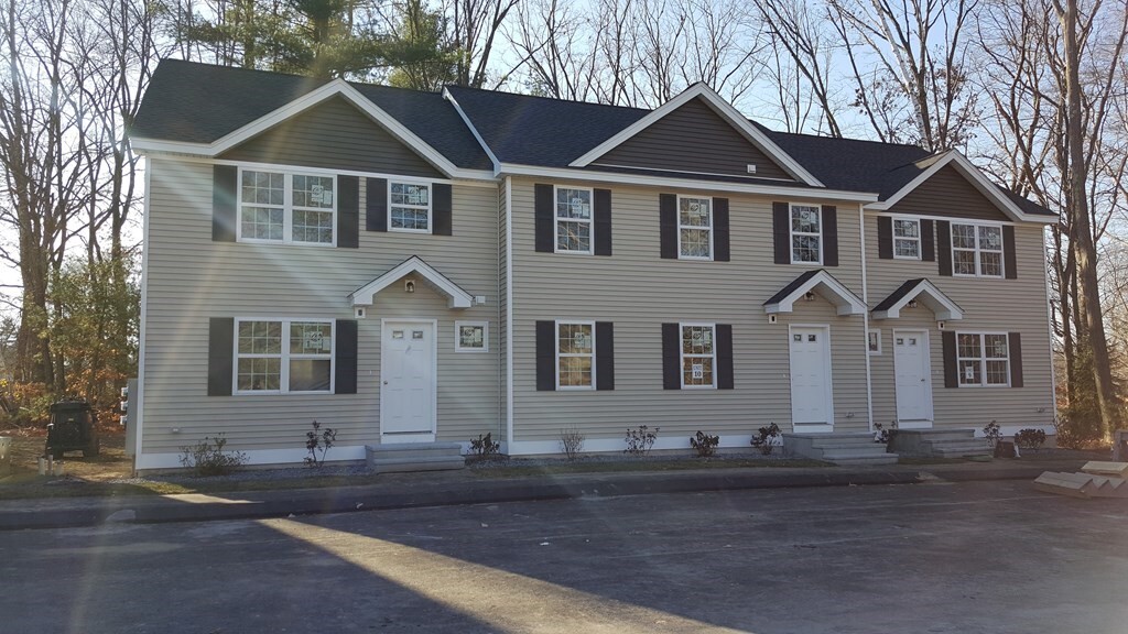
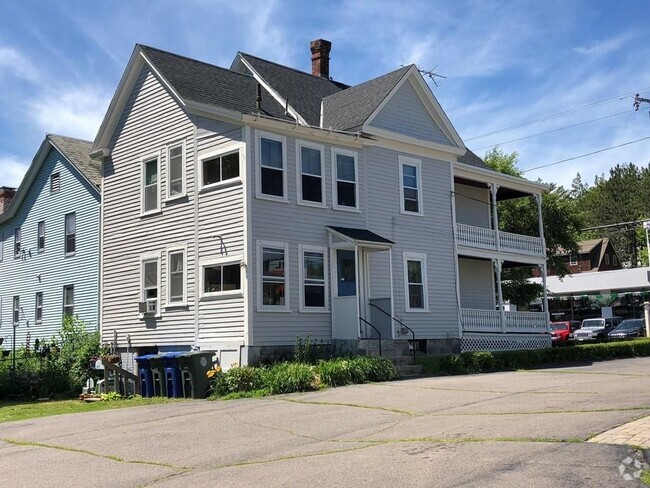
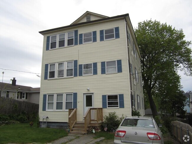
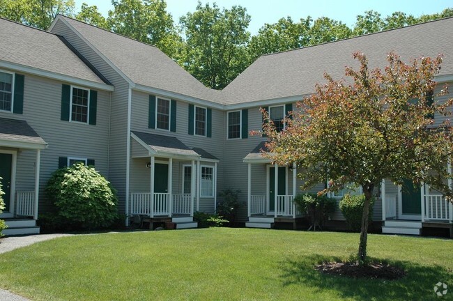
246 High St Ext
Lancaster, MA 01523
2 Weeks Ago
Favorites
246 High St Ext

Favorites
Check Back Soon for Upcoming Availability
| Beds | Baths | Average SF |
|---|---|---|
| 2 Bedrooms 2 Bedrooms 2 Br | 1.5 Baths 1.5 Baths 1.5 Ba | 1,120 SF |
About This Property
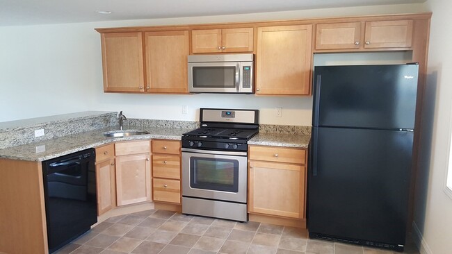
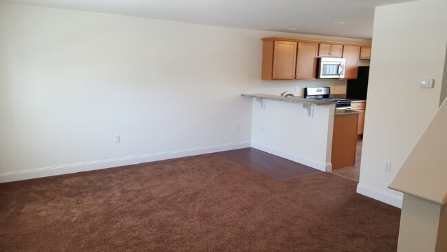
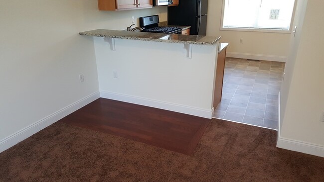
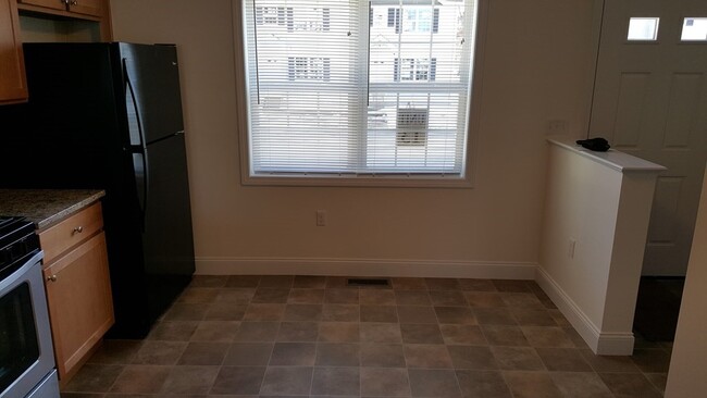
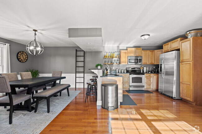
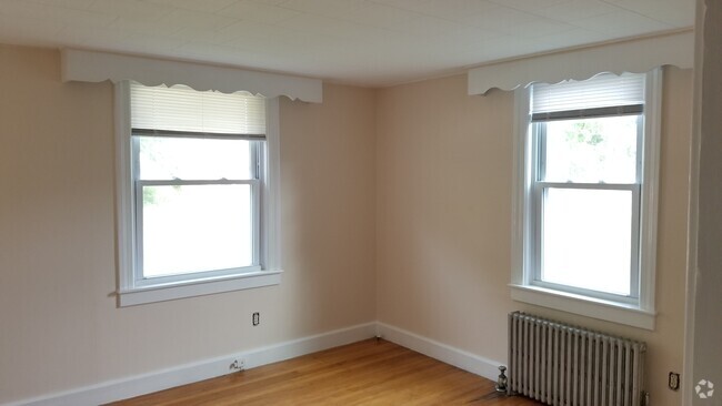
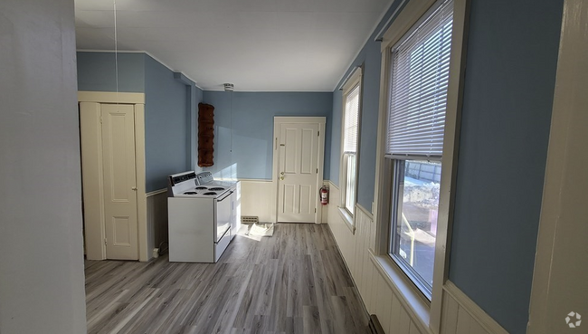
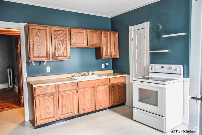
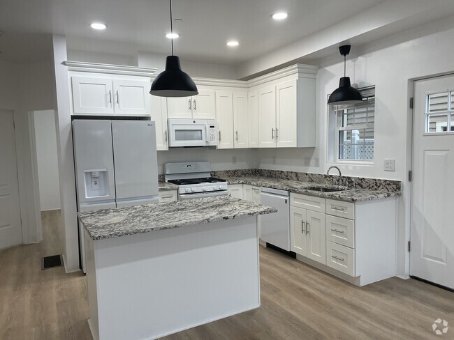
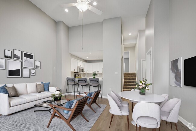
Super nice Triplex condos 16 units in all. located in new residential setting,4 rooms 2 bedrooms 1.5 Baths,granite counter tops with stainless steel & Black appliances,Central A/C with off street parking,Living room,Kitchen,and half bath on 1st floor,2 bedrooms and full bath on 2nd floor,Washer and dryer hook up in basement,Available 10/1/23 SORRY NO PETS,GOOD CREDIT IS A MUST,inside pictures are of similar units
246 High St Ext is a townhome located in Worcester County and the 01523 ZIP Code. This area is served by the Nashoba attendance zone.
Location
Get Directions
Lancaster is a small town that blends sprawling farmland with a few suburban streets. If you travel south along Main Street in this secluded suburb, you’ll find more restaurants and an array of businesses like Michael’s Bridge Diner. Lancaster is adjacent to larger cities, so though it has a tranquil atmosphere, there are more job, dining, shopping, and entertainment opportunities outside of town.
Leominster sits to the west of Lancaster and Clinton sits directly south. The Bolton Flats Wildlife Management Area is to the east of Lancaster, and Interstate 190 is to the west. Check out nearby recreational attractions like the Wachusett Mountain State Reservation including 17 miles of hiking and biking trails and scenic ski slopes, or visit Leominster State Forest for additional hiking and skiing trails, fishing, and mountain climbing.
Learn more about living in Lancaster
Education
| Colleges & Universities | Distance | ||
|---|---|---|---|
| Colleges & Universities | Distance | ||
| Drive: | 27 min | 12.4 mi | |
| Drive: | 25 min | 13.7 mi | |
| Drive: | 25 min | 14.0 mi | |
| Drive: | 33 min | 16.9 mi |
246 High St Ext is within 27 minutes or 12.4 miles from Quinsigamond Community College. It is also near Stillman College and Fitchburg State University.
Schools


Public Elementary School
Grades PK-5
474 Students
Attendance Zone
Public Middle School
Grades 6-8
243 Students
Attendance Zone
Public High School
Grades 9-12
831 Students
Attendance Zone
Private Elementary, Middle & High School
Grades PK-12
273 Students
Nearby
Private Elementary, Middle & High School
Grades 2-12
25 Students
Nearby
School data provided by
 The GreatSchools Rating helps parents compare schools within a state based on a variety of school quality indicators and provides a helpful picture of how effectively each school serves all of its students. Ratings are on a scale of 1 (below average) to 10 (above average) and can include test scores, college readiness, academic progress, advanced courses, equity, discipline and attendance data. We also advise parents to visit schools, consider other information on school performance and programs, and consider family needs as part of the school selection process.
View GreatSchools Rating Methodology
View GreatSchools Rating Methodology
Transportation options available in Lancaster include Riverside Station, located 36.3 miles from 246 High St Ext. 246 High St Ext is near Worcester Regional, located 19.8 miles or 38 minutes away, and General Edward Lawrence Logan International, located 49.4 miles or 66 minutes away.
| Transit / Subway | Distance | ||
|---|---|---|---|
| Transit / Subway | Distance | ||
|
|
Drive: | 48 min | 36.3 mi |
|
|
Drive: | 49 min | 36.7 mi |
|
|
Drive: | 50 min | 37.3 mi |
|
|
Drive: | 52 min | 38.9 mi |
|
|
Drive: | 52 min | 39.1 mi |
| Commuter Rail | Distance | ||
|---|---|---|---|
| Commuter Rail | Distance | ||
|
|
Drive: | 17 min | 9.2 mi |
|
|
Drive: | 19 min | 10.3 mi |
|
|
Drive: | 23 min | 11.6 mi |
|
|
Drive: | 23 min | 15.0 mi |
|
|
Drive: | 27 min | 15.6 mi |
| Airports | Distance | ||
|---|---|---|---|
| Airports | Distance | ||
|
Worcester Regional
|
Drive: | 38 min | 19.8 mi |
|
General Edward Lawrence Logan International
|
Drive: | 66 min | 49.4 mi |
Time and distance from 246 High St Ext.
| Shopping Centers | Distance | ||
|---|---|---|---|
| Shopping Centers | Distance | ||
| Drive: | 4 min | 1.5 mi | |
| Drive: | 4 min | 1.6 mi | |
| Drive: | 10 min | 5.2 mi |
246 High St Ext has 3 shopping centers within 5.2 miles, which is about a 10-minute drive. The miles and minutes will be for the farthest away property.
| Parks and Recreation | Distance | ||
|---|---|---|---|
| Parks and Recreation | Distance | ||
|
Mount Pisgah Conservation Area
|
Drive: | 18 min | 7.3 mi |
|
Tower Hill Botanic Garden
|
Drive: | 13 min | 7.3 mi |
|
Oxbow National Wildlife Refuge
|
Drive: | 13 min | 7.4 mi |
|
Mass Audubon's Lincoln Woods Wildlife Sanctuary
|
Drive: | 18 min | 9.4 mi |
|
Felton Conservation Area
|
Drive: | 20 min | 12.9 mi |
246 High St Ext has 5 parks within 12.9 miles, including Mount Pisgah Conservation Area, Tower Hill Botanic Garden, and Oxbow National Wildlife Refuge.
| Hospitals | Distance | ||
|---|---|---|---|
| Hospitals | Distance | ||
| Drive: | 20 min | 10.6 mi | |
| Drive: | 19 min | 10.6 mi | |
| Drive: | 21 min | 11.6 mi |
246 High St Ext has 3 hospitals within 11.6 miles, the nearest is TaraVista Behavioral Health Center which is 10.6 miles away and a 20 minute drive.
You May Also Like
Similar Rentals Nearby
What Are Walk Score®, Transit Score®, and Bike Score® Ratings?
Walk Score® measures the walkability of any address. Transit Score® measures access to public transit. Bike Score® measures the bikeability of any address.
What is a Sound Score Rating?
A Sound Score Rating aggregates noise caused by vehicle traffic, airplane traffic and local sources

246 High St Ext
Lancaster, MA 01523