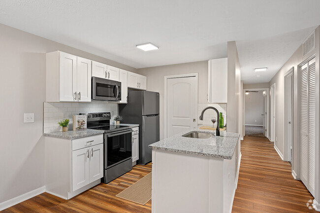
25 W High St
25 W High St,
Oxford,
OH
45056
Check Back Soon for Upcoming Availability
About 25 W High St Oxford, OH 45056
Discover your new place at 25 W High St in Oxford. The location in Oxford's 45056 area has much to offer its residents. The community staff is ready and waiting to show you our community. Make sure you to check out the apartment floorplan options. Come see 25 W High St today.
25 W High St is an apartment community located in Butler County and the 45056 ZIP Code. This area is served by the Talawanda City attendance zone.
Fees and Policies
Details
Property Information
-
Built in 1964
-
8 units/4 stories
Having been built up around Miami University, the small city of Oxford is the epitome of a college town. With around 24,000 students compared to the city’s 21,000 permanent residents, the university serves as the cultural hub for the entire community: annual events like Oxford Wine Festival, recurring series like the Summer Music Festival, and the vibrant dining and nightlife scene downtown all thrive on the support of the college crowd while also providing a huge range of leisure options for students and non-students alike.
The rental market is quite diverse, with affordable options ranging from efficiency apartments just a block or two from campus, to single-family homes at the edge of town, allowing you to find the perfect living arrangements to fit your lifestyle.
Learn more about living in OxfordBelow are rent ranges for similar nearby apartments
| Colleges & Universities | Distance | ||
|---|---|---|---|
| Colleges & Universities | Distance | ||
| Walk: | 15 min | 0.8 mi | |
| Drive: | 30 min | 15.2 mi | |
| Drive: | 43 min | 24.4 mi | |
| Drive: | 55 min | 31.2 mi |
 The GreatSchools Rating helps parents compare schools within a state based on a variety of school quality indicators and provides a helpful picture of how effectively each school serves all of its students. Ratings are on a scale of 1 (below average) to 10 (above average) and can include test scores, college readiness, academic progress, advanced courses, equity, discipline and attendance data. We also advise parents to visit schools, consider other information on school performance and programs, and consider family needs as part of the school selection process.
View GreatSchools Rating Methodology
Transportation options available in Oxford include Brewery District Station, Elm & Henry, located 39.4 miles from 25 W High St. 25 W High St is near Cincinnati/Northern Kentucky International, located 55.0 miles or 81 minutes away.
| Transit / Subway | Distance | ||
|---|---|---|---|
| Transit / Subway | Distance | ||
| Drive: | 59 min | 39.4 mi | |
| Drive: | 59 min | 39.4 mi | |
| Drive: | 59 min | 39.5 mi | |
| Drive: | 59 min | 39.6 mi | |
| Drive: | 59 min | 39.7 mi |
| Commuter Rail | Distance | ||
|---|---|---|---|
| Commuter Rail | Distance | ||
|
|
Drive: | 38 min | 25.5 mi |
|
|
Drive: | 58 min | 39.3 mi |
| Airports | Distance | ||
|---|---|---|---|
| Airports | Distance | ||
|
Cincinnati/Northern Kentucky International
|
Drive: | 81 min | 55.0 mi |
Time and distance from 25 W High St.
| Shopping Centers | Distance | ||
|---|---|---|---|
| Shopping Centers | Distance | ||
| Walk: | 12 min | 0.6 mi | |
| Walk: | 12 min | 0.7 mi | |
| Walk: | 18 min | 0.9 mi |
| Parks and Recreation | Distance | ||
|---|---|---|---|
| Parks and Recreation | Distance | ||
|
Karl Limper Geology Museum
|
Walk: | 14 min | 0.7 mi |
|
Hueston Woods State Nature Preserve
|
Drive: | 14 min | 4.8 mi |
|
Hueston Woods State Park
|
Drive: | 17 min | 6.9 mi |
| Hospitals | Distance | ||
|---|---|---|---|
| Hospitals | Distance | ||
| Walk: | 4 min | 0.2 mi |
| Military Bases | Distance | ||
|---|---|---|---|
| Military Bases | Distance | ||
| Drive: | 75 min | 48.0 mi | |
| Drive: | 81 min | 53.0 mi | |
| Drive: | 83 min | 56.3 mi |
You May Also Like
25 W High St Oxford, OH 45056 is in Uptown Oxford in the city of Oxford. Here you’ll find three shopping centers within 0.9 mile of the property. Three parks are within 6.9 miles, including Karl Limper Geology Museum, Hueston Woods State Nature Preserve, and Hueston Woods State Park.
Similar Rentals Nearby
What Are Walk Score®, Transit Score®, and Bike Score® Ratings?
Walk Score® measures the walkability of any address. Transit Score® measures access to public transit. Bike Score® measures the bikeability of any address.
What is a Sound Score Rating?
A Sound Score Rating aggregates noise caused by vehicle traffic, airplane traffic and local sources


Responded To This Review