
$2,300 / Month
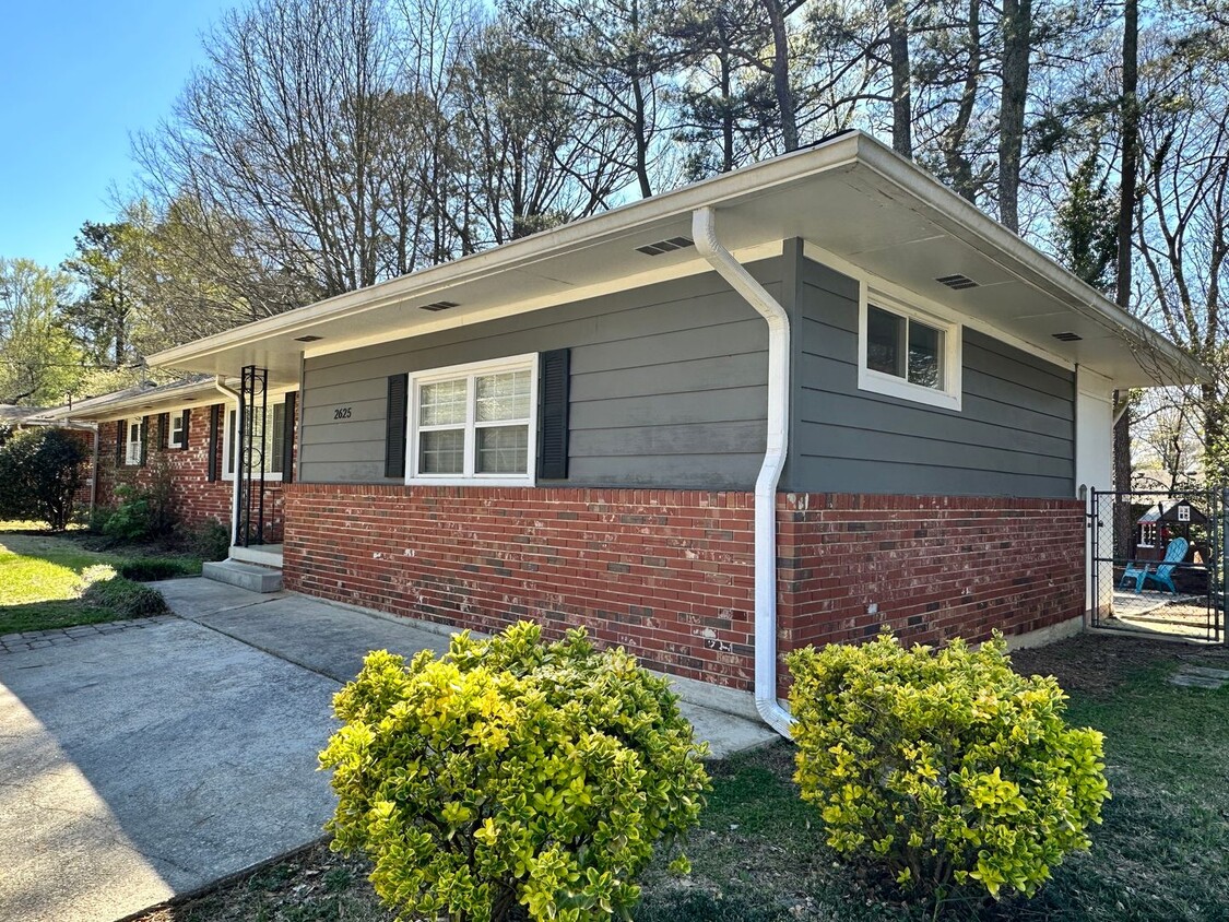
2625 Farley St
East Point, GA 30344
Today
Favorites
770-898-4899
-
Bedrooms
3
-
Bathrooms
2
-
Square Feet
1,856 sq ft
-
Available
Available May 8
2625 Farley St

Favorites
About This Home
$2,300 deposit,
Available May 8
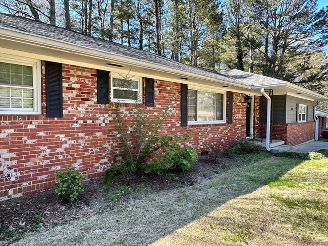
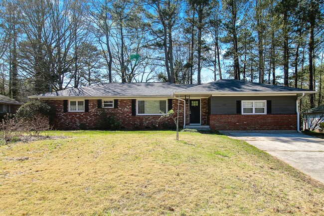
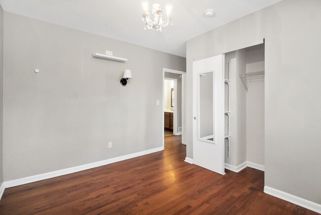
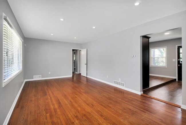
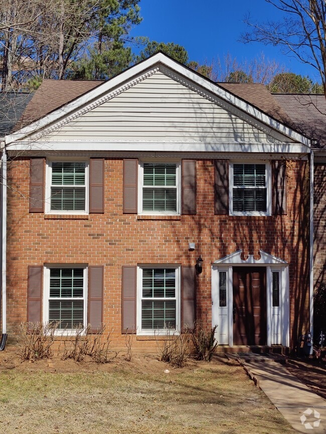
Welcome home to this 3 bedroom 2 full bath all brick ranch style home in the Conley Hill neighborhood. This home is FILLED with TONS of EXTRA perks you don't want to miss! Huge family room with exposed brick accent wall, where the potential is endless! Kitchen boasts plenty of space with ample cabinet and counter space with a separate eat in kitchen. Comes with washer and dryer. Gorgeous hard wood floors throughout the entire home. Updated bathrooms, huge bedrooms with walk-in-closets. Perfect for entertaining with a huge fenced in backyard that comes with outdoor patio furniture, fire pit, gas grill, outdoor decorative lighting and a play set! The backyard leads to a basement with plenty of extra storage space. There is MORE!! This Home also comes with a high end Simplisafe security system throughout the home, Keyless entry with Kwikset Halo Touchpad locks, Nest smart thermostat and Ring Cameras. Located in a well established neighborhood. This piece of paradise is very serene with nature parks nearby and also walking distance to Marta bus stop and Conley Hills elementary school. This location gives you the best of both worlds! Scenic nature views within minutes from the city. Close proximity to downtown East Point, Hartsfield Jackson International Airport, the heart of downtown Atlanta, Tyler Perry Studios and much more. Call today to view this home! It will not last!
2625 Farley St is a house located in Fulton County and the 30344 ZIP Code. This area is served by the Fulton County attendance zone.
* Price shown is base rent and may not include non-optional fees and utilities.
Price, availability, fees, and any applicable rent special are subject to change without notice.
* Square footage definitions vary. Displayed square footage is approximate.
Contact
- Listed by Market South Properties, Inc | Market South Properties, Inc
- Phone Number
- Contact
$2,083 / month
$339,900 Listing Price
4 Beds
•3 Baths
•
1,573 Sq Ft
$1,072 / month
$175,000 Listing Price
3 Beds
•2 Baths
•
1,092 Sq Ft
$1,256 / month
$200,000 Listing Price
3 Beds
•2 Baths
•
1,426 Sq Ft
Location
Get Directions
Aerotropolis refers to an array of Southside Atlanta communities surrounding Hartsfield-Jackson Atlanta International Airport, the world’s busiest airport. The cities of College Park, Chattahoochee Hills, East Point, Fairburn, Forest Park, Union City, Hapeville, Morrow, and Palmetto are all a part of the Aerotropolis Alliance, working together on initiatives to improve their respective communities.
Aerotropolis’ close proximity to the airport makes the region an ideal choice for local employees and frequent travelers alike. A wide variety of rentals are available throughout the region, from luxury apartments and cozy condos to charming townhomes and spacious houses. Getting around from Aerotropolis is easy with access to I-75, I-85, and I-285.
Learn more about living in Aerotropolis
Education
| Colleges & Universities | Distance | ||
|---|---|---|---|
| Colleges & Universities | Distance | ||
| Drive: | 11 min | 5.3 mi | |
| Drive: | 12 min | 6.0 mi | |
| Drive: | 15 min | 6.0 mi | |
| Drive: | 14 min | 6.2 mi |
2625 Farley St is within 11 minutes or 5.3 miles from Atlanta Metropolitan State. It is also near Atlanta Technical College and Morehouse School of Medicine.
Schools


Public Elementary School
Grades PK-5
397 Students
Attendance Zone
Public Middle School
Grades 6-8
803 Students
Attendance Zone
Public High School
Grades 9-12
1,483 Students
Attendance Zone
Private Elementary, Middle & High School
Grades PK-12
Nearby
Private Elementary School
Grades PK-6
32 Students
Nearby
School data provided by
 The GreatSchools Rating helps parents compare schools within a state based on a variety of school quality indicators and provides a helpful picture of how effectively each school serves all of its students. Ratings are on a scale of 1 (below average) to 10 (above average) and can include test scores, college readiness, academic progress, advanced courses, equity, discipline and attendance data. We also advise parents to visit schools, consider other information on school performance and programs, and consider family needs as part of the school selection process.
View GreatSchools Rating Methodology
View GreatSchools Rating Methodology
Transportation options available in East Point include East Point, located 2.2 miles from 2625 Farley St. 2625 Farley St is near Hartsfield - Jackson Atlanta International, located 7.4 miles or 15 minutes away.
| Transit / Subway | Distance | ||
|---|---|---|---|
| Transit / Subway | Distance | ||
|
|
Drive: | 6 min | 2.2 mi |
|
|
Drive: | 7 min | 3.5 mi |
|
|
Drive: | 8 min | 3.5 mi |
|
|
Drive: | 8 min | 4.3 mi |
|
|
Drive: | 12 min | 5.4 mi |
| Commuter Rail | Distance | ||
|---|---|---|---|
| Commuter Rail | Distance | ||
|
|
Drive: | 21 min | 12.7 mi |
| Airports | Distance | ||
|---|---|---|---|
| Airports | Distance | ||
|
Hartsfield - Jackson Atlanta International
|
Drive: | 15 min | 7.4 mi |
Time and distance from 2625 Farley St.
| Shopping Centers | Distance | ||
|---|---|---|---|
| Shopping Centers | Distance | ||
| Walk: | 9 min | 0.5 mi | |
| Walk: | 10 min | 0.5 mi | |
| Drive: | 3 min | 1.3 mi |
2625 Farley St has 3 shopping centers within 1.3 miles, which is about a 3-minute walk. The miles and minutes will be for the farthest away property.
| Parks and Recreation | Distance | ||
|---|---|---|---|
| Parks and Recreation | Distance | ||
|
West Atlanta Watershed Alliance (WAWA)
|
Drive: | 10 min | 4.1 mi |
|
Cascade Springs Nature Preserve
|
Drive: | 10 min | 4.3 mi |
|
Atlanta BeltLine Southwest Connector Spur Trail
|
Drive: | 12 min | 4.9 mi |
|
Park Pride
|
Drive: | 13 min | 6.7 mi |
|
Zoo Atlanta
|
Drive: | 16 min | 7.9 mi |
2625 Farley St has 5 parks within 7.9 miles, including Cascade Springs Nature Preserve, West Atlanta Watershed Alliance (WAWA), and Atlanta BeltLine Southwest Connector Spur Trail.
| Hospitals | Distance | ||
|---|---|---|---|
| Hospitals | Distance | ||
| Drive: | 15 min | 7.7 mi | |
| Drive: | 18 min | 8.2 mi | |
| Drive: | 16 min | 8.4 mi |
2625 Farley St has 3 hospitals within 8.4 miles, the nearest is Grady Memorial Hospital which is 7.7 miles away and a 15 minute drive.
| Military Bases | Distance | ||
|---|---|---|---|
| Military Bases | Distance | ||
| Drive: | 9 min | 4.1 mi | |
| Drive: | 26 min | 13.0 mi |
2625 Farley St is 4.1 miles from Fort McPherson, and is convenient to other military bases, including Fort Gillem.
You May Also Like
Similar Rentals Nearby
-
-
-
-
-
-
-
1 / 28
-
-
-
What Are Walk Score®, Transit Score®, and Bike Score® Ratings?
Walk Score® measures the walkability of any address. Transit Score® measures access to public transit. Bike Score® measures the bikeability of any address.
What is a Sound Score Rating?
A Sound Score Rating aggregates noise caused by vehicle traffic, airplane traffic and local sources
2625 Farley St
East Point, GA 30344