
$9,000 / Month
27 Panoramic Way
Berkeley, CA 94704
Today
Favorites
510-219-1387
-
Bedrooms
3
-
Bathrooms
3
-
Square Feet
2,200 sq ft
-
Available
Available Now
Highlights
- Views of Golden Gate Bridge
- Bay View
- Wood Flooring
- Breakfast Room
- Laundry closet
- Central Heating
27 Panoramic Way

Favorites
About This Home
$9,000 deposit,
Available Now
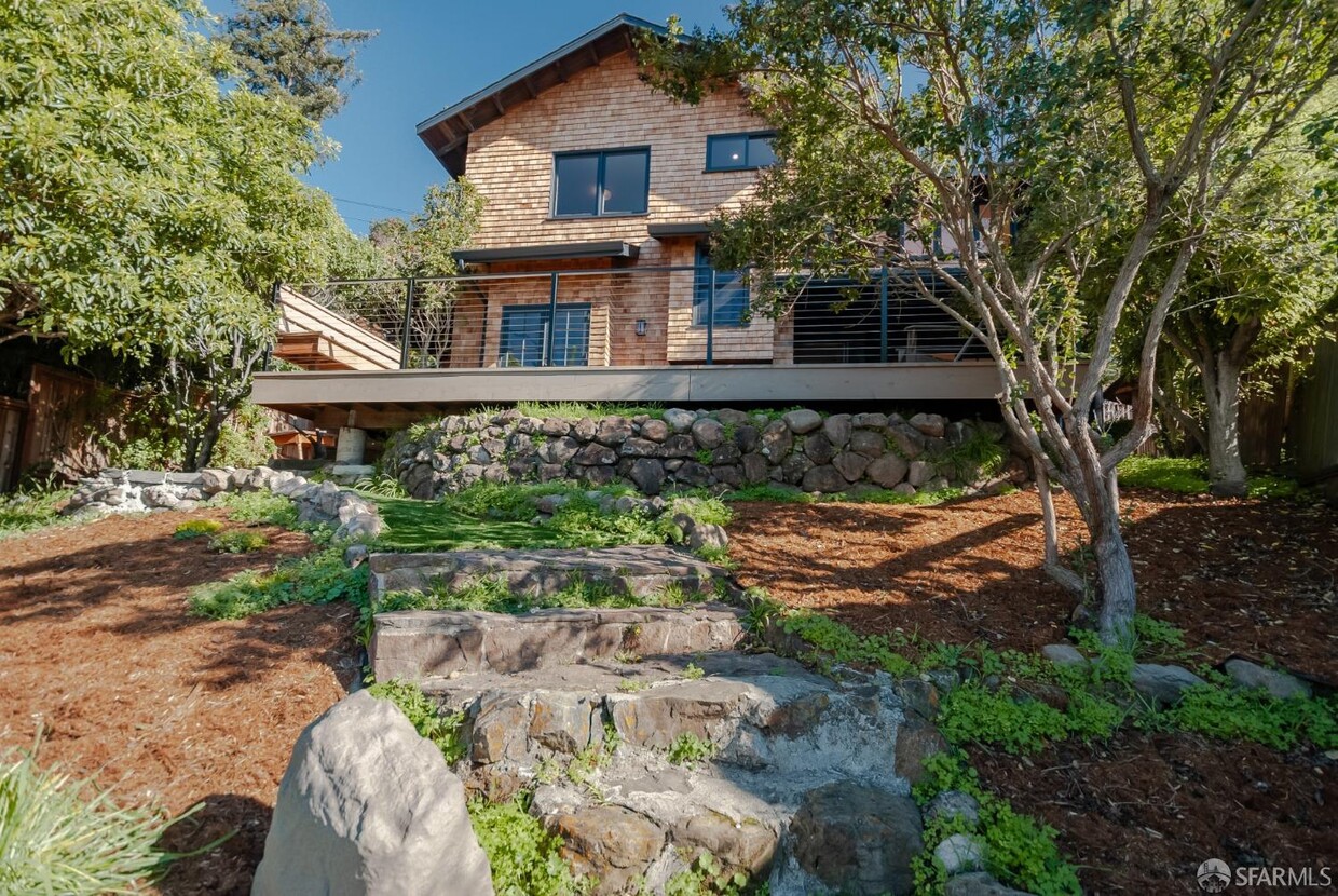
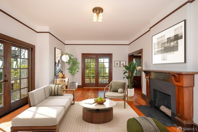
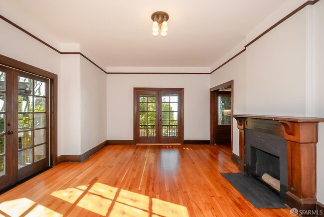
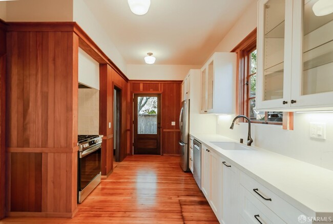
This is 27 Panoramic! A classic brown-shingled Craftsman nestled in the Berkeley Hillsoffering stunning bay views, exquisite wood detailing, and a serene yet convenient location. Close to the action, yet buffered by winding roads and serene trees, this lovingly maintained hill house blends original details and modern features that elevate the classic architecture inside and out. The thoughtful layout includes a formal dining room with bay views, a breakfast nook, a large family room, and an office space. The updated kitchen features all new appliances and flows easily into the dining room and breakfast nook, both with charming built-ins. French doors in the bright living room open to a gorgeous deck overlooking the San Francisco Bay, perfect for entertaining or al fresco dining. Upstairs, the primary bedroom boasts a fireplace, bay views, and a newly updated ensuite bathroom. There are two more spacious bedrooms (one with bay views) an updated bathroom, a washer/dryer closet, and a unique office nook with - you guessed it - bay views. Just minutes from UC Berkeley, Downtown, College Ave, Whole Foods, Domingo shops, and Tilden Park, this home offers easy access to dining, shopping, and outdoor adventuresplus a convenient commute to San Francisco.
27 Panoramic Way is a house located in Alameda County and the 94704 ZIP Code. This area is served by the Berkeley Unified attendance zone.
* Price shown is base rent and may not include non-optional fees and utilities.
Price, availability, fees, and any applicable rent special are subject to change without notice.
* Square footage definitions vary. Displayed square footage is approximate.
Home Details
Home Type
Single Family Detached Home
Year Built
Built in 1903 | Remodeled
Bedrooms and Bathrooms
3 Full Bathrooms
Interior Spaces
Wood Flooring
2,200 Sq Ft Home
2-Story Property
Kitchen
Breakfast Room
Free-Standing Gas Oven
Free-Standing Gas Range
Dishwasher
Laundry
Laundry closet
Stacked Washer and Dryer
Listing and Financial Details
Security Deposit $9,000
12 Month Lease Term
Assessor Parcel Number 055186100502
1-Year Minimum Lease Term
Lot Details
6,192 Sq Ft Lot
Parking
Leased Parking
1 Carport Space
Open Parking
Parking Available
3 Parking Spaces
Utilities
Central Heating
Views
Golden Gate Bridge
San Francisco
Bay
Views of the Bay Bridge
Bridge
City Lights
Community Details
Pet Policy
Cats Allowed
Contact
- Listed by Lisa McCarrel | Corcoran Icon Properties
- Phone Number
- Website View Property Website
- Contact
-
Source
San Francisco Association of Realtors
Copyright © 2025 San Francisco Association of REALTORS. All rights reserved. All information provided by the listing agent/broker is deemed reliable but is not guaranteed and should be independently verified.
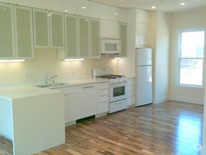
$8,749 / month
$1,495,000 Listing Price
5 Beds
•4 Baths
•
2,394 Sq Ft
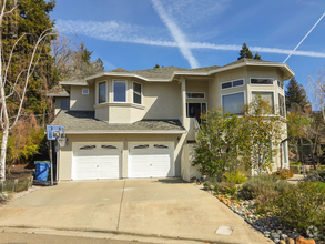
$8,108 / month
$1,250,000 Listing Price
3 Beds
•3.5 Baths
•
2,540 Sq Ft
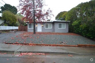
$10,060 / month
$1,699,000 Listing Price
3 Beds
•3.5 Baths
•
3,134 Sq Ft
Location
Get Directions
Amenities
- Air Conditioning
- Smoke Free
- Tub/Shower
- Sprinkler System
- Oven
- Range
- Breakfast Nook
- Hardwood Floors
- Carpet
- Patio
The Southside community is located near the University of California, Berkeley. Students and residents can enjoy a variety of fare offered at restaurants that surround this 40,000-student public research campus. Public transportation is abound thanks to the Bay Area Rapid Transit rail station and bus stops near Southside.
You’ll discover numerous coffee shops, two cinemas, and cool museums near the college’s campus buildings and bookstores. Residents and students are close by to the Claremont Canyon Regional Preserve, which is an exceptional hiking destination that overlooks the San Francisco Bay.
Learn more about living in Southside
Education
| Colleges & Universities | Distance | ||
|---|---|---|---|
| Colleges & Universities | Distance | ||
| Walk: | 14 min | 0.8 mi | |
| Drive: | 5 min | 1.7 mi | |
| Drive: | 12 min | 4.0 mi | |
| Drive: | 13 min | 5.7 mi |
27 Panoramic Way is within 14 minutes or 0.8 mile from UC Berkeley. It is also near Berkeley City College and Samuel Merritt University.
Schools


Public Elementary School
Grades K-5
270 Students
Attendance Zone
Public Elementary School
Grades K-5
263 Students
Attendance Zone
Public Elementary School
Grades K-5
270 Students
Nearby
Public Middle School
Grades 6-8
596 Students
Attendance Zone
Public High School
Grades 9-12
3,204 Students
Attendance Zone
Private Elementary School
Grades K-5
Nearby
Private Elementary & Middle School
Grades K-8
106 Students
Nearby
Private Elementary School
Grades PK-5
58 Students
Nearby
Private High School
Grades 9-12
109 Students
Nearby
School data provided by
 The GreatSchools Rating helps parents compare schools within a state based on a variety of school quality indicators and provides a helpful picture of how effectively each school serves all of its students. Ratings are on a scale of 1 (below average) to 10 (above average) and can include test scores, college readiness, academic progress, advanced courses, equity, discipline and attendance data. We also advise parents to visit schools, consider other information on school performance and programs, and consider family needs as part of the school selection process.
View GreatSchools Rating Methodology
View GreatSchools Rating Methodology
Transportation options available in Berkeley include Downtown Berkeley Station, located 1.6 miles from 27 Panoramic Way. 27 Panoramic Way is near Metro Oakland International, located 14.8 miles or 24 minutes away, and San Francisco International, located 25.3 miles or 42 minutes away.
| Transit / Subway | Distance | ||
|---|---|---|---|
| Transit / Subway | Distance | ||
|
|
Drive: | 5 min | 1.6 mi |
|
|
Drive: | 6 min | 2.1 mi |
|
|
Drive: | 8 min | 2.4 mi |
|
|
Drive: | 7 min | 2.5 mi |
|
|
Drive: | 12 min | 5.3 mi |
| Commuter Rail | Distance | ||
|---|---|---|---|
| Commuter Rail | Distance | ||
|
|
Drive: | 10 min | 3.3 mi |
|
|
Drive: | 12 min | 3.9 mi |
|
|
Drive: | 13 min | 6.5 mi |
| Drive: | 23 min | 12.8 mi | |
| Drive: | 25 min | 14.1 mi |
| Airports | Distance | ||
|---|---|---|---|
| Airports | Distance | ||
|
Metro Oakland International
|
Drive: | 24 min | 14.8 mi |
|
San Francisco International
|
Drive: | 42 min | 25.3 mi |
Time and distance from 27 Panoramic Way.
| Shopping Centers | Distance | ||
|---|---|---|---|
| Shopping Centers | Distance | ||
| Drive: | 3 min | 1.2 mi | |
| Drive: | 4 min | 1.4 mi | |
| Drive: | 5 min | 1.8 mi |
27 Panoramic Way has 3 shopping centers within 1.8 miles, which is about a 5-minute drive. The miles and minutes will be for the farthest away property.
| Parks and Recreation | Distance | ||
|---|---|---|---|
| Parks and Recreation | Distance | ||
|
People's Park
|
Walk: | 13 min | 0.7 mi |
|
Willard Park
|
Walk: | 19 min | 1.0 mi |
|
University and Jepson Herbaria
|
Drive: | 6 min | 1.6 mi |
|
Essig Museum of Entomology
|
Drive: | 6 min | 1.6 mi |
|
UC Berkeley Museum of Paleontology
|
Drive: | 6 min | 1.6 mi |
27 Panoramic Way has 5 parks within 1.6 miles, including People's Park, University and Jepson Herbaria, and Essig Museum of Entomology.
| Hospitals | Distance | ||
|---|---|---|---|
| Hospitals | Distance | ||
| Drive: | 4 min | 1.4 mi | |
| Drive: | 9 min | 3.0 mi | |
| Drive: | 11 min | 3.6 mi |
27 Panoramic Way has 3 hospitals within 3.6 miles, the nearest is Alta Bates Summit Medical Center - Alta Bates Campus which is 1.4 miles away and a 4 minute drive.
| Military Bases | Distance | ||
|---|---|---|---|
| Military Bases | Distance | ||
| Drive: | 14 min | 4.7 mi | |
| Drive: | 20 min | 8.2 mi |
27 Panoramic Way is 4.7 miles from Military Reservation, and is convenient to other military bases, including Oakland Army Base.
You May Also Like
Similar Rentals Nearby


What Are Walk Score®, Transit Score®, and Bike Score® Ratings?
Walk Score® measures the walkability of any address. Transit Score® measures access to public transit. Bike Score® measures the bikeability of any address.
What is a Sound Score Rating?
A Sound Score Rating aggregates noise caused by vehicle traffic, airplane traffic and local sources

27 Panoramic Way
Berkeley, CA 94704