
$4,800 / Month
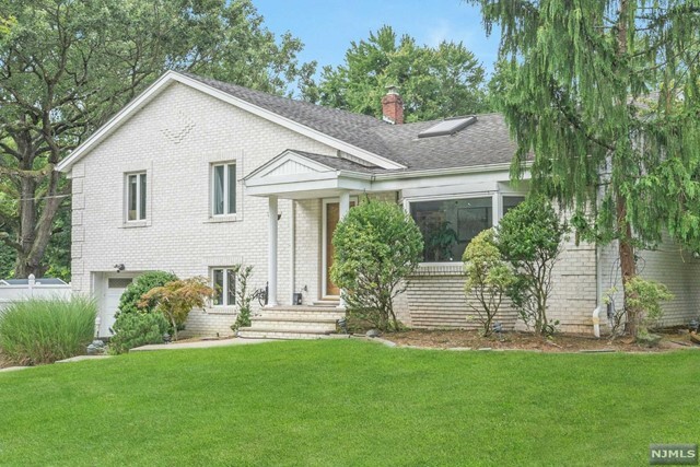
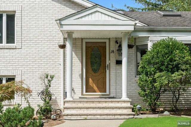
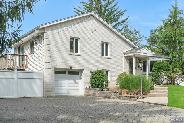
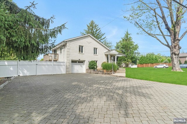
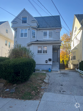
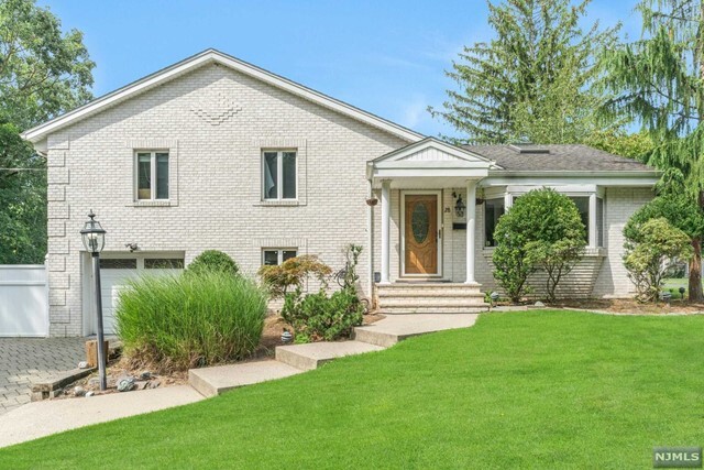
28 Highland Ave
Harrington Park, NJ 07640
2 Weeks Ago
Favorites
28 Highland Ave

Favorites
Check Back Soon for Upcoming Availability
| Beds | Baths | Average SF |
|---|---|---|
| 3 Bedrooms 3 Bedrooms 3 Br | 2 Baths 2 Baths 2 Ba | — |
About This Property
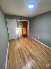
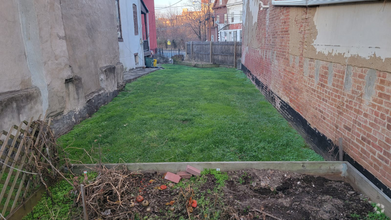
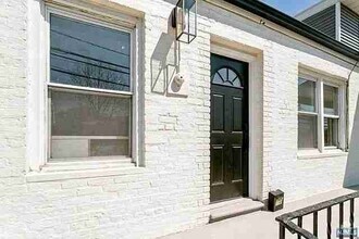
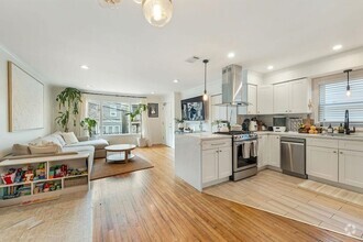
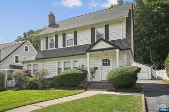
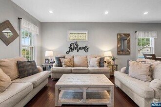
A DOUBLE LOT WITH OUTDOOR KITCHEN AND BBQ. SPRINKLER WITH NEWER FERTILIZER SYSTEM. CHARMING SPLIT LEVEL SITTING HIGH ON THE PROERTY WITH HARDWOOD FLOOR THROUGHOUT, SKYLIGHTS AND CATHDERAL CEILINGS. UPDATED KITCHEN AND BATHROOMS WITH STONE AND GRANITE. PRIMARY BEDROOM WITH FULL BATHROOM. A FOURTH BEDROOM/DEN ON THE GROUND LEVEL. LARGE LIVING ROOM WITH A BEAUTIFUL BAY WINDOW. DINING ROOM. NEW FURNACE INSTALLED 2022. 2ND FLOOR BATHROOM UPGRADED LED AND PAINTED 2021. GARDEN SHED AND A HUGE PARK-LIKE PLAY/ENTERTAINMENT AREA FOR CHILDREN AND GUESTS. BULE RIBBON SCHOOLS, NYC TRANSPORTATION. LAWN CARE IS LANDLORD'S RESPONSIBILITY AND SNOW REMOVAL IS TENANT'S RESPONSIBILITY.
28 Highland Ave is a house located in Bergen County and the 07640 ZIP Code. This area is served by the Northern Valley Regional High attendance zone.
Location
Get Directions
Harrington Park sits on the shores of the Oradell Reservoir in northern New Jersey, not far from the state’s border with New York. This upscale suburban area attracts a broad range of renters looking for a convenient yet quiet rental in a close-knit community. There are local restaurants and boutiques to enjoy all around Harrington Park in communities like Norwood and Northvale. To the east lies the Palisades, a sprawling park that also surrounds the interstate parkway with the same name.
Hackensack is just a 20-minute drive south, meaning Harrington Park is far from secluded from the numerous cities in eastern New Jersey. Want to head into New York City? Palisades Parkway will have you in the center of Manhattan in just 30 minutes (on a good day).
Learn more about living in Harrington Park
Education
| Colleges & Universities | Distance | ||
|---|---|---|---|
| Colleges & Universities | Distance | ||
| Drive: | 8 min | 5.4 mi | |
| Drive: | 10 min | 5.9 mi | |
| Drive: | 21 min | 10.9 mi | |
| Drive: | 26 min | 15.5 mi |
28 Highland Ave is within 8 minutes or 5.4 miles from Saint Thomas Aquinas College. It is also near Dominican College and Bergen C.C., Paramus.
Schools


Public Elementary, Middle & High School
Grades PK-12
197 Students
Nearby
Public Elementary & Middle School
Grades PK-8
615 Students
Attendance Zone
Public High School
Grades 9-12
1,002 Students
Attendance Zone
Private Elementary School
Grades PK-K
68 Students
Nearby
Private Elementary School
Grades PK-1
25 Students
Nearby
Private High School
Grades 9-12
493 Students
Nearby
Private High School
Grades 11-12
Nearby
School data provided by
 The GreatSchools Rating helps parents compare schools within a state based on a variety of school quality indicators and provides a helpful picture of how effectively each school serves all of its students. Ratings are on a scale of 1 (below average) to 10 (above average) and can include test scores, college readiness, academic progress, advanced courses, equity, discipline and attendance data. We also advise parents to visit schools, consider other information on school performance and programs, and consider family needs as part of the school selection process.
View GreatSchools Rating Methodology
View GreatSchools Rating Methodology
Transportation options available in Harrington Park include Marble Hill-225 Street, located 15.4 miles from 28 Highland Ave. 28 Highland Ave is near Laguardia, located 22.3 miles or 36 minutes away, and Westchester County, located 25.8 miles or 38 minutes away.
| Transit / Subway | Distance | ||
|---|---|---|---|
| Transit / Subway | Distance | ||
|
|
Drive: | 25 min | 15.4 mi |
|
|
Drive: | 25 min | 16.2 mi |
|
|
Drive: | 26 min | 16.7 mi |
|
|
Drive: | 27 min | 17.2 mi |
|
|
Drive: | 28 min | 17.5 mi |
| Commuter Rail | Distance | ||
|---|---|---|---|
| Commuter Rail | Distance | ||
|
|
Drive: | 6 min | 4.3 mi |
|
|
Drive: | 7 min | 4.5 mi |
|
|
Drive: | 9 min | 5.4 mi |
|
|
Drive: | 9 min | 6.1 mi |
|
|
Drive: | 33 min | 20.0 mi |
| Airports | Distance | ||
|---|---|---|---|
| Airports | Distance | ||
|
Laguardia
|
Drive: | 36 min | 22.3 mi |
|
Westchester County
|
Drive: | 38 min | 25.8 mi |
Time and distance from 28 Highland Ave.
| Shopping Centers | Distance | ||
|---|---|---|---|
| Shopping Centers | Distance | ||
| Drive: | 3 min | 1.4 mi | |
| Drive: | 2 min | 1.6 mi | |
| Drive: | 4 min | 2.0 mi |
28 Highland Ave has 3 shopping centers within 2.0 miles, which is about a 4-minute drive. The miles and minutes will be for the farthest away property.
| Parks and Recreation | Distance | ||
|---|---|---|---|
| Parks and Recreation | Distance | ||
|
Closter Nature Center
|
Drive: | 5 min | 1.9 mi |
|
Demarest Nature Center
|
Drive: | 4 min | 2.3 mi |
|
Pascack Brook County Park
|
Drive: | 8 min | 3.5 mi |
|
Tallman Mountain State Park
|
Drive: | 9 min | 5.2 mi |
|
Wood Dale County Park
|
Drive: | 11 min | 6.8 mi |
28 Highland Ave has 5 parks within 6.8 miles, including Closter Nature Center, Demarest Nature Center, and Pascack Brook County Park.
| Hospitals | Distance | ||
|---|---|---|---|
| Hospitals | Distance | ||
| Drive: | 5 min | 3.1 mi | |
| Drive: | 10 min | 6.5 mi | |
| Drive: | 11 min | 6.6 mi |
28 Highland Ave has 3 hospitals within 6.6 miles, the nearest is Hackensack Meridian Health Pascack Valley Medical which is 3.1 miles away and a 5 minute drive.
| Military Bases | Distance | ||
|---|---|---|---|
| Military Bases | Distance | ||
| Drive: | 37 min | 23.8 mi |
28 Highland Ave is 23.8 miles and a 37 minute drive from Fort Totten US Govt Reservation.
You May Also Like
Similar Rentals Nearby


What Are Walk Score®, Transit Score®, and Bike Score® Ratings?
Walk Score® measures the walkability of any address. Transit Score® measures access to public transit. Bike Score® measures the bikeability of any address.
What is a Sound Score Rating?
A Sound Score Rating aggregates noise caused by vehicle traffic, airplane traffic and local sources
28 Highland Ave
Harrington Park, NJ 07640