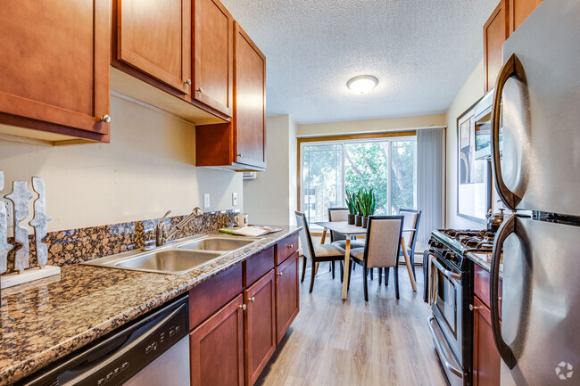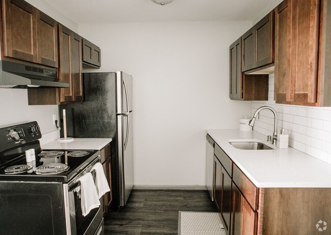
-
Monthly Rent
$1,295
-
Bedrooms
1 bd
-
Bathrooms
1 ba
-
Square Feet
750 sq ft
Details

 This Property
 Available Property
East Lyn-Lake makes up the eastern portion of the neighborhood Lyn-Lake and is defined by the prominent intersection of two main streets, Lake Street and Lyndale Avenue. This well-known intersection acts as a magnet for unique shops, galleries, restaurants, and entertainment. East Lyn-Lake sits immediately east of Uptown, another popular urban area in Minneapolis. Nestled just three miles southwest of Downtown Minneapolis, residents can easily reach the most popular neighborhoods in the city. Apartments and condos available for rent in the area vary from mid-range to upscale. Locals enjoy strolling or biking along the neighborhood’s walkable and bikeable streets to check out all of the top-notch local businesses.
Learn more about living in East Lyn-Lake| Colleges & Universities | Distance | ||
|---|---|---|---|
| Colleges & Universities | Distance | ||
| Drive: | 6 min | 1.9 mi | |
| Drive: | 7 min | 2.1 mi | |
| Drive: | 7 min | 2.4 mi | |
| Drive: | 9 min | 4.0 mi |
Transportation options available in Minneapolis include Nicollet Mall Station, located 2.5 miles from 2825 Garfield Ave Unit 2. 2825 Garfield Ave Unit 2 is near Minneapolis-St Paul International/Wold-Chamberlain, located 11.4 miles or 21 minutes away.
| Transit / Subway | Distance | ||
|---|---|---|---|
| Transit / Subway | Distance | ||
|
|
Drive: | 8 min | 2.5 mi |
|
|
Drive: | 8 min | 2.5 mi |
|
|
Drive: | 8 min | 2.7 mi |
|
|
Drive: | 9 min | 2.8 mi |
|
|
Drive: | 8 min | 3.8 mi |
| Commuter Rail | Distance | ||
|---|---|---|---|
| Commuter Rail | Distance | ||
|
|
Drive: | 9 min | 3.1 mi |
|
|
Drive: | 17 min | 9.9 mi |
|
|
Drive: | 19 min | 11.8 mi |
|
|
Drive: | 32 min | 21.0 mi |
|
|
Drive: | 33 min | 22.7 mi |
| Airports | Distance | ||
|---|---|---|---|
| Airports | Distance | ||
|
Minneapolis-St Paul International/Wold-Chamberlain
|
Drive: | 21 min | 11.4 mi |
Time and distance from 2825 Garfield Ave Unit 2.
| Shopping Centers | Distance | ||
|---|---|---|---|
| Shopping Centers | Distance | ||
| Walk: | 12 min | 0.6 mi | |
| Walk: | 14 min | 0.8 mi | |
| Walk: | 15 min | 0.8 mi |
| Parks and Recreation | Distance | ||
|---|---|---|---|
| Parks and Recreation | Distance | ||
|
Whittier Park
|
Walk: | 6 min | 0.4 mi |
|
Bryant Square Park
|
Walk: | 10 min | 0.5 mi |
|
Mueller Park
|
Walk: | 13 min | 0.7 mi |
|
Painter Park
|
Walk: | 13 min | 0.7 mi |
|
Washburn Fair Oaks Park
|
Drive: | 3 min | 1.1 mi |
| Hospitals | Distance | ||
|---|---|---|---|
| Hospitals | Distance | ||
| Drive: | 4 min | 1.2 mi | |
| Drive: | 5 min | 1.5 mi | |
| Drive: | 8 min | 2.7 mi |
| Military Bases | Distance | ||
|---|---|---|---|
| Military Bases | Distance | ||
| Drive: | 17 min | 9.2 mi |
You May Also Like
Similar Rentals Nearby
What Are Walk Score®, Transit Score®, and Bike Score® Ratings?
Walk Score® measures the walkability of any address. Transit Score® measures access to public transit. Bike Score® measures the bikeability of any address.
What is a Sound Score Rating?
A Sound Score Rating aggregates noise caused by vehicle traffic, airplane traffic and local sources


