$1,600 / Month
2841 Westknolls Ln
Cincinnati, OH 45211
Today
Favorites
513-654-2681
-
Bedrooms
4
-
Bathrooms
2
-
Square Feet
1,200 sq ft
-
Available
Available Now
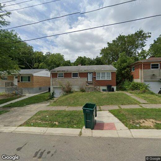
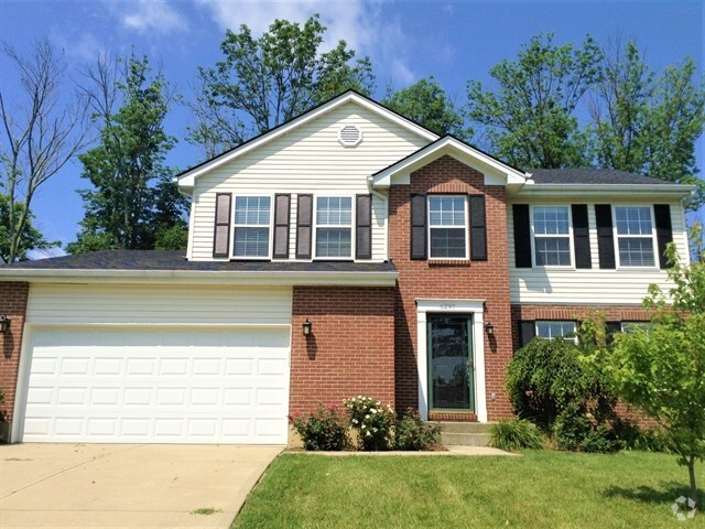
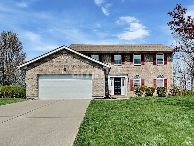
2841 Westknolls Ln

Favorites
About This Home
Available Now
Discover a beautifully painted 4-bed, 2-bath, 1,200 sq ft Single Family Home at 2841 Westknolls Lane. In this property Rent is $1600, with Section 8 accepted. Pets are allowed with a $50 monthly fee per pet Applicants need an income of 3 times the rent, a clean rental history, and no recent evictions or criminal records. Move-in with $0 security deposit - Rhino insurance accepted, reducing move-in costs. Enjoy best-in-class amenities in Westwood, about five miles northwest of Downtown Cincinnati. Explore parks like the 1,400-acre Mount Airy Forest for outdoor enjoyment. To Book Showing or Apply: Visit or Call . Note: Images are for representation purposes only, and the actual property units may vary in Configuration, Quality & Appearance. For move-in specials please text or call Miguel at
2841 Westknolls Ln is a house located in Hamilton County and the 45211 ZIP Code. This area is served by the Cincinnati Public Schools attendance zone.
* Price shown is base rent and may not include non-optional fees and utilities.
Price, availability, fees, and any applicable rent special are subject to change without notice.
* Square footage definitions vary. Displayed square footage is approximate.
Fees and Policies
The fees below are based on community-supplied data and may exclude additional fees and utilities.
- Dogs Allowed
-
Fees not specified
- Cats Allowed
-
Fees not specified
Contact
- Listed by Leasing Agent
- Phone Number
- Contact
Location
Get Directions
Situated about five miles northwest of Downtown Cincinnati, Westwood is the largest neighborhood in the city. Residents flock to Westwood for its many affordable historic homes and modern apartments available for rent in addition to its close proximity to I-74, I-75, and all that Downtown Cincinnati has to offer.
While Westwood is a predominantly residential neighborhood, it is also home to a slew of convenient stores and restaurants. Shopping opportunities abound in Westwood, with plenty of national retailers in Western Hills Plaza and local shops in the growing Town Hall District. Numerous neighborhood parks provide ample space to enjoy the outdoors in town as well as the sprawling 1,400-acre Mount Airy Forest, which is partially located in Westwood.
Learn more about living in Westwood
Education
| Colleges & Universities | Distance | ||
|---|---|---|---|
| Colleges & Universities | Distance | ||
| Drive: | 13 min | 4.4 mi | |
| Drive: | 11 min | 4.7 mi | |
| Drive: | 13 min | 5.1 mi | |
| Drive: | 17 min | 7.0 mi |
2841 Westknolls Ln is within 13 minutes or 4.4 miles from Cincinnati State. It is also near University of Cincinnati and Univ. of Cincinnati, Medical.
Schools


Public Elementary School
Grades PK-6
409 Students
Attendance Zone
Public Middle & High School
Grades 7-12
760 Students
Attendance Zone
Public Middle & High School
Grades 6-12
1,418 Students
Attendance Zone
Private Elementary & Middle School
Grades PK-8
381 Students
Nearby
Private Elementary & Middle School
Grades K-8
164 Students
Nearby
Private High School
Grades 9-12
495 Students
Nearby
School data provided by
 The GreatSchools Rating helps parents compare schools within a state based on a variety of school quality indicators and provides a helpful picture of how effectively each school serves all of its students. Ratings are on a scale of 1 (below average) to 10 (above average) and can include test scores, college readiness, academic progress, advanced courses, equity, discipline and attendance data. We also advise parents to visit schools, consider other information on school performance and programs, and consider family needs as part of the school selection process.
View GreatSchools Rating Methodology
View GreatSchools Rating Methodology
Transportation options available in Cincinnati include Brewery District Station, Elm & Henry, located 3.8 miles from 2841 Westknolls Ln. 2841 Westknolls Ln is near Cincinnati/Northern Kentucky International, located 18.1 miles or 34 minutes away.
| Transit / Subway | Distance | ||
|---|---|---|---|
| Transit / Subway | Distance | ||
| Drive: | 9 min | 3.8 mi | |
| Drive: | 9 min | 4.0 mi | |
| Drive: | 10 min | 4.0 mi | |
| Drive: | 10 min | 4.1 mi | |
| Drive: | 10 min | 4.3 mi |
| Commuter Rail | Distance | ||
|---|---|---|---|
| Commuter Rail | Distance | ||
|
|
Drive: | 9 min | 4.0 mi |
| Airports | Distance | ||
|---|---|---|---|
| Airports | Distance | ||
|
Cincinnati/Northern Kentucky International
|
Drive: | 34 min | 18.1 mi |
Time and distance from 2841 Westknolls Ln.
| Shopping Centers | Distance | ||
|---|---|---|---|
| Shopping Centers | Distance | ||
| Drive: | 5 min | 2.0 mi | |
| Drive: | 5 min | 2.2 mi | |
| Drive: | 8 min | 3.0 mi |
2841 Westknolls Ln has 3 shopping centers within 3.0 miles, which is about a 8-minute drive. The miles and minutes will be for the farthest away property.
| Parks and Recreation | Distance | ||
|---|---|---|---|
| Parks and Recreation | Distance | ||
|
Imago Earth Center
|
Drive: | 11 min | 3.6 mi |
|
Mt. Airy Forest
|
Drive: | 10 min | 3.7 mi |
|
Wilson Commons
|
Drive: | 10 min | 4.0 mi |
|
Museum of Natural History and Science
|
Drive: | 9 min | 4.0 mi |
|
Cincinnati History Museum
|
Drive: | 9 min | 4.0 mi |
2841 Westknolls Ln has 5 parks within 4.0 miles, including Imago Earth Center, Mt. Airy Forest, and Wilson Commons.
| Hospitals | Distance | ||
|---|---|---|---|
| Hospitals | Distance | ||
| Drive: | 10 min | 3.9 mi | |
| Drive: | 12 min | 4.7 mi | |
| Drive: | 12 min | 4.8 mi |
2841 Westknolls Ln has 3 hospitals within 4.8 miles, the nearest is Good Samaritan Hospital which is 3.9 miles away and a 10 minute drive.
| Military Bases | Distance | ||
|---|---|---|---|
| Military Bases | Distance | ||
| Drive: | 75 min | 56.0 mi | |
| Drive: | 81 min | 61.1 mi | |
| Drive: | 83 min | 64.4 mi |
2841 Westknolls Ln has 3 military bases within 64.4 miles, the nearest is Gentile Air Force Station which is 56.0 miles away and a 75 minute drive.
You May Also Like
Similar Rentals Nearby
-
-
-
-
-
-
-
-
 $2,8604 Beds, 2.5 Baths, 3,072 sq ftHouse for Rent
 -
 $2,7954 Beds, 2.5 Baths, 2,317 sq ftHouse for Rent
 -
What Are Walk Score®, Transit Score®, and Bike Score® Ratings?
Walk Score® measures the walkability of any address. Transit Score® measures access to public transit. Bike Score® measures the bikeability of any address.
What is a Sound Score Rating?
A Sound Score Rating aggregates noise caused by vehicle traffic, airplane traffic and local sources

2841 Westknolls Ln
Cincinnati, OH 45211