
$1,900 / Month
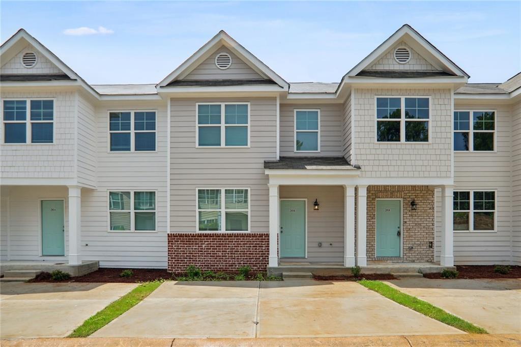
2850 Laurel Ridge Cir
East Point, GA 30344
1 Day Ago
Favorites
470-776-2562
-
Bedrooms
3
-
Bathrooms
2.5
-
Square Feet
1,490 sq ft
-
Available
Available Now
Highlights
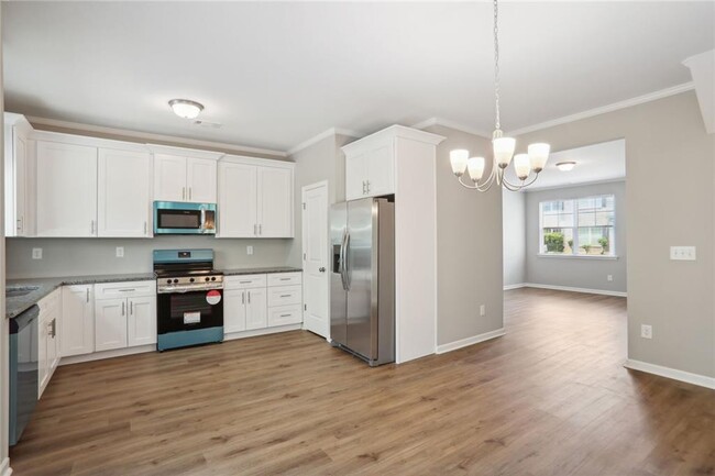
- Open-Concept Dining Room
- Traditional Architecture
- Solid Surface Countertops
- White Kitchen Cabinets
- Ceiling height of 9 feet on the main level
- Double Pane Windows
2850 Laurel Ridge Cir

Favorites
About This Home
Available Now
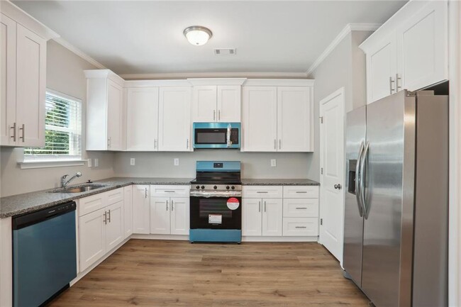
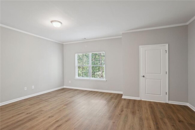
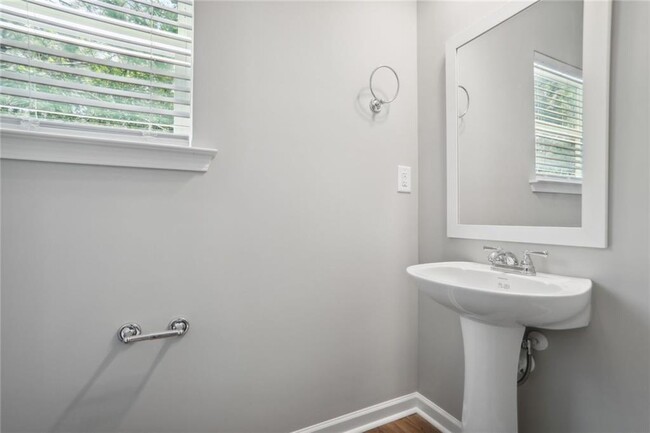
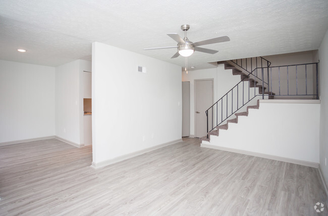
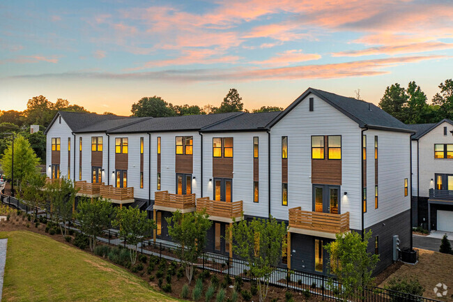
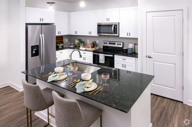
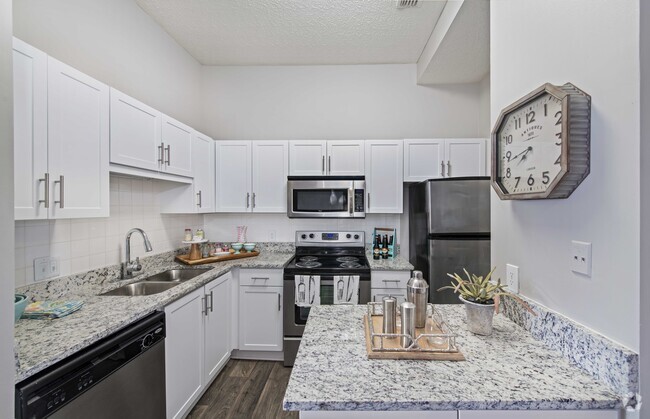
Discover the perfect blend of modern living and serene surroundings in this stunning new construction townhome! Featuring sleek stainless-steel appliances and an inviting open floor plan adorned with beautiful granite countertops,this home is designed for both comfort and style. Upstairs,you'll find two cozy bedrooms along with a well-appointed bathroom,complementing a spacious master suite complete with a generous walk-in closet and an elegant full bath. The home overlooks lush greenery-a rare gem in the heart of the city! The unfinished basement offers ample storage space,allowing you to keep your living areas clutter-free. Plus,you'll love the unbeatable location: just minutes away from Camp Creek Marketplace,one of Atlanta's premier shopping destinations,and quick access to I-285 for easy commuting. Don't miss out on this exceptional opportunity to make this beautiful townhome your new sanctuary!
2850 Laurel Ridge Cir is a townhome located in Fulton County and the 30344 ZIP Code. This area is served by the Fulton County attendance zone.
* Price shown is base rent and may not include non-optional fees and utilities.
Price, availability, fees, and any applicable rent special are subject to change without notice.
* Square footage definitions vary. Displayed square footage is approximate.
Home Details
Home Type
Townhome
Year Built
Built in 2024
Bedrooms and Bathrooms
Bathtub and Shower Combination in Primary Bathroom
2.5 Bathrooms
3 Bedrooms
Flooring
Luxury Vinyl Tile
Carpet
Home Design
Traditional Architecture
Composition Roof
HardiePlank Type
Frame Construction
Home Security
Fire and Smoke Detector
Interior Spaces
Open-Concept Dining Room
Ceiling height of 9 feet on the main level
Double Pane Windows
1,490 Sq Ft Home
2-Story Property
Kitchen
Solid Surface Countertops
White Kitchen Cabinets
Microwave
Dishwasher
Disposal
Listing and Financial Details
Security Deposit $2,000
$150 Move-In Fee
12 Month Lease Term
$40 Application Fee
Lot Details
7,841 Sq Ft Lot
Landscaped
Two or More Common Walls
Back Yard
Cleared Lot
Parking
Driveway
2 Parking Spaces
Schools
Brookview Elementary School
Woodland - Fulton Middle School
Tri-Cities High School
Unfinished Basement
Basement Fills Entire Space Under The House
Utilities
Forced Air Heating and Cooling System
Cable TV Available
Phone Available
Underground Utilities
Electric Water Heater
Community Details
Overview
Application Fee Required
Laurel Townhomes Subdivision
Pet Policy
Call for details about the types of pets allowed
Pet Deposit $300
Contact
- Listed by Micah Miller | GMAP Realty
- Phone Number (470) 776-2562
- Contact
-
Source
 First Multiple Listing Service, Inc.
Copyright © 2025 First Multiple Listing Service, Inc. All rights reserved. All information provided by the listing agent/broker is deemed reliable but is not guaranteed and should be independently verified.
$1,787 / month
$295,000 Listing Price
3 Beds
•2.5 Baths
•
1,517 Sq Ft
$1,598 / month
$225,000 Listing Price
3 Beds
•2.5 Baths
Location
Get Directions
Amenities
- Dishwasher
- Disposal
- Microwave
- Refrigerator
Aerotropolis refers to an array of Southside Atlanta communities surrounding Hartsfield-Jackson Atlanta International Airport, the world’s busiest airport. The cities of College Park, Chattahoochee Hills, East Point, Fairburn, Forest Park, Union City, Hapeville, Morrow, and Palmetto are all a part of the Aerotropolis Alliance, working together on initiatives to improve their respective communities.
Aerotropolis’ close proximity to the airport makes the region an ideal choice for local employees and frequent travelers alike. A wide variety of rentals are available throughout the region, from luxury apartments and cozy condos to charming townhomes and spacious houses. Getting around from Aerotropolis is easy with access to I-75, I-85, and I-285.
Learn more about living in Aerotropolis
Education
| Colleges & Universities | Distance | ||
|---|---|---|---|
| Colleges & Universities | Distance | ||
| Drive: | 16 min | 10.1 mi | |
| Drive: | 18 min | 10.5 mi | |
| Drive: | 20 min | 10.7 mi | |
| Drive: | 20 min | 10.8 mi |
2850 Laurel Ridge Cir is within 16 minutes or 10.1 miles from Atlanta Metropolitan State. It is also near Atlanta Technical College and Morehouse School of Medicine.
Schools
Public Elementary School
Grades PK-5
416 Students
Attendance Zone
5
Out of 10
Public Middle School
Grades 6-8
799 Students
Attendance Zone
3
Out of 10
Public High School
Grades 9-12
1,483 Students
Attendance Zone
2
Out of 10
Private Elementary, Middle & High School
Grades PK-12
127 Students
Nearby
Private Elementary School
Grades PK-5
Nearby
School data provided by
GreatSchools
The GreatSchools Rating helps parents compare schools within a state based on a variety of school quality indicators and provides a helpful picture of how effectively each school serves all of its students. Ratings are on a scale of 1 (below average) to 10 (above average) and can include test scores, college readiness, academic progress, advanced courses, equity, discipline and attendance data. We also advise parents to visit schools, consider other information on school performance and programs, and consider family needs as part of the school selection process.
Transportation options available in East Point include College Park, located 3.6 miles from 2850 Laurel Ridge Cir. 2850 Laurel Ridge Cir is near Hartsfield - Jackson Atlanta International, located 9.1 miles or 16 minutes away.
| Transit / Subway | Distance | ||
|---|---|---|---|
| Transit / Subway | Distance | ||
|
|
Drive: | 7 min | 3.6 mi |
|
|
Drive: | 8 min | 4.0 mi |
|
|
Drive: | 11 min | 5.5 mi |
|
|
Drive: | 13 min | 7.4 mi |
|
|
Drive: | 14 min | 8.2 mi |
| Commuter Rail | Distance | ||
|---|---|---|---|
| Commuter Rail | Distance | ||
|
|
Drive: | 26 min | 16.6 mi |
| Airports | Distance | ||
|---|---|---|---|
| Airports | Distance | ||
|
Hartsfield - Jackson Atlanta International
|
Drive: | 16 min | 9.1 mi |
Time and distance from 2850 Laurel Ridge Cir.
| Shopping Centers | Distance | ||
|---|---|---|---|
| Shopping Centers | Distance | ||
| Walk: | 20 min | 1.1 mi | |
| Drive: | 5 min | 1.7 mi | |
| Drive: | 4 min | 1.7 mi |
2850 Laurel Ridge Cir has 3 shopping centers within 1.7 miles, which is about a 4-minute walk. The miles and minutes will be for the farthest away property.
| Parks and Recreation | Distance | ||
|---|---|---|---|
| Parks and Recreation | Distance | ||
|
Cascade Springs Nature Preserve
|
Drive: | 11 min | 7.1 mi |
|
West Atlanta Watershed Alliance (WAWA)
|
Drive: | 16 min | 8.9 mi |
|
Atlanta BeltLine Southwest Connector Spur Trail
|
Drive: | 16 min | 9.4 mi |
|
Park Pride
|
Drive: | 19 min | 11.2 mi |
|
Zoo Atlanta
|
Drive: | 21 min | 12.5 mi |
2850 Laurel Ridge Cir has 5 parks within 12.5 miles, including Cascade Springs Nature Preserve, West Atlanta Watershed Alliance (WAWA), and Atlanta BeltLine Southwest Connector Spur Trail.
| Hospitals | Distance | ||
|---|---|---|---|
| Hospitals | Distance | ||
| Drive: | 13 min | 6.6 mi | |
| Drive: | 18 min | 9.5 mi | |
| Drive: | 17 min | 10.2 mi |
2850 Laurel Ridge Cir has 3 hospitals within 10.2 miles, the nearest is Southern Crescent Behavioral Health System - Anchor Hospital Campus which is 6.6 miles away and a 13 minute drive.
| Military Bases | Distance | ||
|---|---|---|---|
| Military Bases | Distance | ||
| Drive: | 15 min | 8.0 mi | |
| Drive: | 25 min | 15.4 mi |
2850 Laurel Ridge Cir is 8.0 miles from Fort McPherson, and is convenient to other military bases, including Fort Gillem.
You May Also Like
Similar Rentals Nearby


What Are Walk Score®, Transit Score®, and Bike Score® Ratings?
Walk Score® measures the walkability of any address. Transit Score® measures access to public transit. Bike Score® measures the bikeability of any address.
What is a Sound Score Rating?
A Sound Score Rating aggregates noise caused by vehicle traffic, airplane traffic and local sources
2850 Laurel Ridge Cir
East Point, GA 30344