
$2,080 / Month
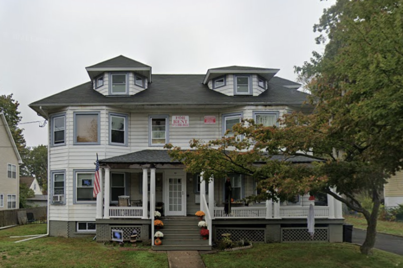
29 High St Unit 1R
West Orange, NJ 07052
2 Weeks Ago
Favorites
29 High St Unit 1R

Favorites
Check Back Soon for Upcoming Availability
| Beds | Baths | Average SF |
|---|---|---|
| 1 Bedroom 1 Bedroom 1 Br | 1 Bath 1 Bath 1 Ba | — |
About This Property
Property Id: 1668396 LOVELY 1 BEDROOM LOOKING FOR A PEACEFUL TENANT TO BE A FAMILY MEMEBR WITH WWHM NEWLY RENOVATED FOR THE RIGHT PERSON ::::::::::::::::::::::::::::::::::::::::::::::::::::::::::::::::::: SECTION 8 WELCOME
29 High St is an apartment community located in Essex County and the 07052 ZIP Code.
Features
- Oven
- Lawn
Fees and Policies
The fees below are based on community-supplied data and may exclude additional fees and utilities.
Details
Utilities Included
-
Water
-
Trash Removal
-
Sewer
Property Address:
29 High St,
West Orange,
NJ
07052
West Orange is an upscale suburban community located about thirty miles west of Manhattan. The township is best known for its historic Llewellyn Park neighborhood, filled with Victorian homes that once belonged to such prominent citizens as Thomas Edison (Edison’s factory is one of the city’s distinctive landmarks as well). Most of the landscape in West Orange is covered by residential neighborhoods, with the popular Essex Green Shopping Center in the middle of town serving as the hub for shopping, dining, and entertainment.
When the weather is nice, locals love to hit the links at the nearby golf courses or explore the trails of South Mountain and Eagle Rock reservations. Seton Hall University sits just a few blocks southeast of town, making West Orange a great place for students, faculty, and staff members to live.
Learn more about living in West Orange
Amenities
- Oven
- Lawn
Expenses
Utilities Included
Water, Trash Removal, Sewer
Included
Education
| Colleges & Universities | Distance | ||
|---|---|---|---|
| Colleges & Universities | Distance | ||
| Drive: | 7 min | 2.6 mi | |
| Drive: | 11 min | 4.2 mi | |
| Drive: | 11 min | 4.9 mi | |
| Drive: | 12 min | 5.2 mi |
29 High St Unit 1R is within 7 minutes or 2.6 miles from Bloomfield College. It is also near Seton Hall University and N.J. Inst. of Technology.
Transportation options available in West Orange include Grove Street, located 2.9 miles from 29 High St Unit 1R. 29 High St Unit 1R is near Newark Liberty International, located 10.5 miles or 20 minutes away, and Laguardia, located 31.3 miles or 50 minutes away.
| Transit / Subway | Distance | ||
|---|---|---|---|
| Transit / Subway | Distance | ||
|
|
Drive: | 8 min | 2.9 mi |
|
|
Drive: | 10 min | 3.6 mi |
|
|
Drive: | 10 min | 3.6 mi |
|
|
Drive: | 10 min | 3.7 mi |
|
|
Drive: | 9 min | 4.4 mi |
| Commuter Rail | Distance | ||
|---|---|---|---|
| Commuter Rail | Distance | ||
|
|
Drive: | 5 min | 1.6 mi |
|
|
Drive: | 6 min | 1.9 mi |
|
|
Drive: | 6 min | 1.9 mi |
|
|
Drive: | 7 min | 2.1 mi |
|
|
Drive: | 6 min | 2.2 mi |
| Airports | Distance | ||
|---|---|---|---|
| Airports | Distance | ||
|
Newark Liberty International
|
Drive: | 20 min | 10.5 mi |
|
Laguardia
|
Drive: | 50 min | 31.3 mi |
Time and distance from 29 High St Unit 1R.
| Shopping Centers | Distance | ||
|---|---|---|---|
| Shopping Centers | Distance | ||
| Drive: | 5 min | 1.7 mi | |
| Drive: | 5 min | 2.0 mi | |
| Drive: | 7 min | 2.1 mi |
29 High St Unit 1R has 3 shopping centers within 2.1 miles, which is about a 7-minute drive. The miles and minutes will be for the farthest away property.
| Parks and Recreation | Distance | ||
|---|---|---|---|
| Parks and Recreation | Distance | ||
|
Edison National Historic Site
|
Drive: | 5 min | 1.4 mi |
|
Van Vleck House & Gardens
|
Drive: | 6 min | 2.5 mi |
|
Turtle Back Zoo
|
Drive: | 11 min | 4.0 mi |
|
Presby Memorial Iris Gardens
|
Drive: | 10 min | 4.7 mi |
|
Branch Brook Park
|
Drive: | 11 min | 4.7 mi |
29 High St Unit 1R has 5 parks within 4.7 miles, including Edison National Historic Site, Van Vleck House & Gardens, and Turtle Back Zoo.
| Hospitals | Distance | ||
|---|---|---|---|
| Hospitals | Distance | ||
| Drive: | 7 min | 3.2 mi | |
| Drive: | 9 min | 4.6 mi | |
| Drive: | 10 min | 4.7 mi |
29 High St Unit 1R has 3 hospitals within 4.7 miles, the nearest is East Orange General Hospital which is 3.2 miles away and a 7 minute drive.
| Military Bases | Distance | ||
|---|---|---|---|
| Military Bases | Distance | ||
| Drive: | 25 min | 14.3 mi | |
| Drive: | 31 min | 16.7 mi | |
| Drive: | 35 min | 16.9 mi |
29 High St Unit 1R has 3 military bases within 16.9 miles, the nearest is Military Ocean Terminal which is 14.3 miles away and a 25 minute drive.
You May Also Like
Similar Rentals Nearby


What Are Walk Score®, Transit Score®, and Bike Score® Ratings?
Walk Score® measures the walkability of any address. Transit Score® measures access to public transit. Bike Score® measures the bikeability of any address.
What is a Sound Score Rating?
A Sound Score Rating aggregates noise caused by vehicle traffic, airplane traffic and local sources
29 High St
West Orange, NJ 07052