
$2,250 / Month
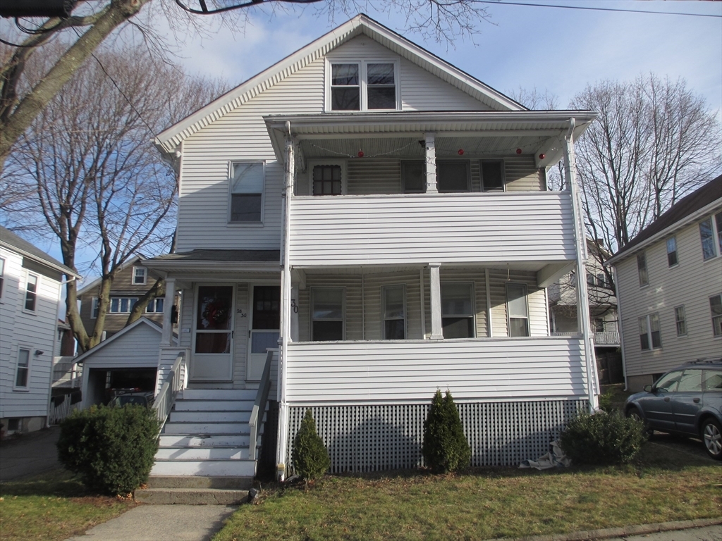
30 Watson Rd
Belmont, MA 02478
Today
Favorites
617-460-4292
-
Bedrooms
1
-
Bathrooms
1
-
Square Feet
980 sq ft
-
Available
Available Now
Highlights
- Property is near public transit
- Community Pool
- Jogging Path
- Porch
- No Cooling
- Patio
30 Watson Rd Unit 30

Favorites
About This Home
$2,250 deposit,
Available Now
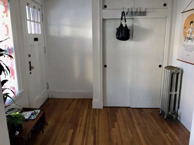
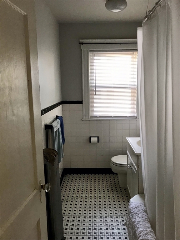
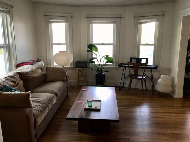
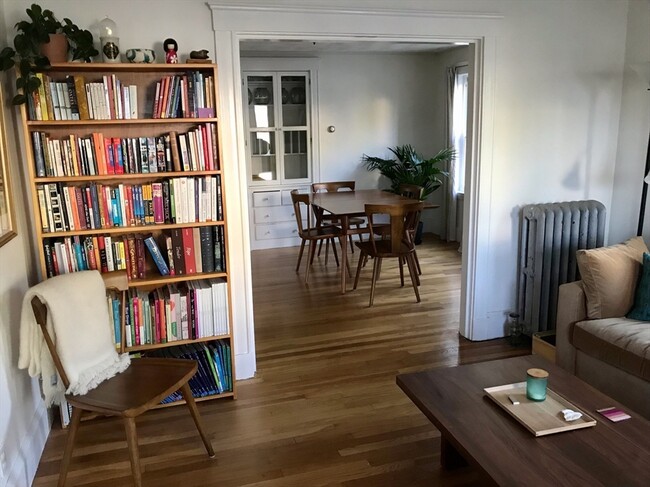
INCREDIBLE VALUE! Spacious 1 bed/1bath apartment located in a great neighborhood of Belmont near the Cambridge/Fresh Pond line. Walking distance to local public schools including Belmont High School,Burbank Elementary and Wellington Elementary. Bus stops to Alewife right down the street on Concord Ave. This apartment boasts hardwood floors in the large living room,dining room and bedroom. Nice classic built-ins in dining room and kitchen. Generous closet space and extra storage in the basement. Eat in kitchen with gas stove,disposal and dishwasher. Washer/Dryer in basement. Backyard with plenty of room for outside activities/grilling.
30 Watson Rd is an apartment community located in Middlesex County and the 02478 ZIP Code.
* Price shown is base rent and may not include non-optional fees and utilities.
Price, availability, fees, and any applicable rent special are subject to change without notice.
* Square footage definitions vary. Displayed square footage is approximate.
Home Details
Accessible Home Design
Entry on the 1st floor
Bedrooms and Bathrooms
1 Full Bathroom
1 Bedroom
Home Design
Apartment
Interior Spaces
980 Sq Ft Home
Kitchen
Range
Dishwasher
Disposal
Listing and Financial Details
Security Deposit $2,250
Property Available on 3/15/25
Rent includes gardener, extra storage, parking
Location
Property is near public transit
Property is near schools
Lot Details
4,770 Sq Ft Lot
Outdoor Features
Porch
Patio
Parking
2 Parking Spaces
Utilities
No Cooling
Heating System Uses Natural Gas
Community Details
Amenities
Shops
Laundry Facilities
Overview
No Home Owners Association
Pet Policy
Call for details about the types of pets allowed
Recreation
Community Pool
Jogging Path
Park
Contact
- Listed by Alex Rufo
- Phone Number (617) 460-4292
-
Source
 MLS Property Information Network
The property listing data and information set forth herein were provided to MLS Property Information Network, Inc. from third party sources, including sellers, lessors and public records, and were compiled by MLS Property Information Network, Inc. The property listing data and information are for the personal, non-commercial use of consumers having a good faith interest in purchasing or leasing listed properties of the type displayed to them and may not be used for any purpose other than to identify prospective properties which such consumers may have a good faith interest in purchasing or leasing. MLS Property Information Network, Inc. and its subscribers disclaim any and all representations and warranties as to the accuracy of the property listing data and information set forth herein. All properties are subject to prior sale, change or withdrawal. Copyright © 2025 MLS Property Information Network, Inc. All rights reserved.
Location
Get Directions
Amenities
- Dishwasher
- Disposal
- Range
- Refrigerator
- Patio
- Porch
Situated on Cambridge’s western border, about eight miles from Downtown Boston, Belmont is a picturesque suburb boasting a close-knit, small-town feel. Primarily a residential community, Belmont is known to locals as “the Town of Homes” with beautiful houses lining the Pleasant Street Historic District. Local businesses and popular chains also populate Leonard Street’s commercial corridor in Belmont.
Belmont offers residents easy access to Downtown Boston via the T and major roadways in addition to scenic natural surroundings. Convenience to Beaver Brook North Reservation, Rock Meadow Conservation Area, Lone Tree Hill, Claypit Pond, and Robbins Farm Park allows Belmont residents the opportunity to connect with nature at any time while nearby Harvard Square and Downtown Boston present endless options for metropolitan endeavors as well.
Learn more about living in Belmont
Education
| Colleges & Universities | Distance | ||
|---|---|---|---|
| Colleges & Universities | Distance | ||
| Drive: | 6 min | 2.4 mi | |
| Drive: | 6 min | 2.7 mi | |
| Drive: | 7 min | 3.3 mi | |
| Drive: | 7 min | 3.6 mi |
30 Watson Rd Unit 30 is within 6 minutes or 2.4 miles from Lesley University. It is also near Lesley University, Porter and Harvard University.
Transportation options available in Belmont include Alewife Station, located 1.8 miles from 30 Watson Rd Unit 30. 30 Watson Rd Unit 30 is near General Edward Lawrence Logan International, located 11.6 miles or 20 minutes away.
| Transit / Subway | Distance | ||
|---|---|---|---|
| Transit / Subway | Distance | ||
|
|
Drive: | 4 min | 1.8 mi |
|
|
Drive: | 6 min | 2.7 mi |
|
|
Drive: | 7 min | 3.1 mi |
|
|
Drive: | 6 min | 3.2 mi |
| Drive: | 7 min | 3.9 mi |
| Commuter Rail | Distance | ||
|---|---|---|---|
| Commuter Rail | Distance | ||
|
|
Walk: | 19 min | 1.0 mi |
|
|
Drive: | 4 min | 2.1 mi |
|
|
Drive: | 7 min | 2.7 mi |
|
|
Drive: | 7 min | 3.9 mi |
| Drive: | 12 min | 6.2 mi |
| Airports | Distance | ||
|---|---|---|---|
| Airports | Distance | ||
|
General Edward Lawrence Logan International
|
Drive: | 20 min | 11.6 mi |
Time and distance from 30 Watson Rd Unit 30.
| Shopping Centers | Distance | ||
|---|---|---|---|
| Shopping Centers | Distance | ||
| Walk: | 21 min | 1.1 mi | |
| Drive: | 2 min | 1.3 mi | |
| Drive: | 3 min | 1.5 mi |
30 Watson Rd Unit 30 has 3 shopping centers within 1.5 miles, which is about a 3-minute drive. The miles and minutes will be for the farthest away property.
| Parks and Recreation | Distance | ||
|---|---|---|---|
| Parks and Recreation | Distance | ||
|
Mass Audubon's Habitat Education Center and Wildlife Sanctuary
|
Drive: | 6 min | 2.1 mi |
|
Harvard-Smithsonian Center for Astrophysics
|
Drive: | 5 min | 2.1 mi |
|
Longfellow National Historic Site
|
Drive: | 5 min | 2.4 mi |
|
Beaver Brook Reservation
|
Drive: | 5 min | 2.5 mi |
|
Harvard Museum of Natural History
|
Drive: | 7 min | 2.8 mi |
30 Watson Rd Unit 30 has 5 parks within 2.8 miles, including Mass Audubon's Habitat Education Center and Wildlife Sanctuary, Harvard-Smithsonian Center for Astrophysics, and Beaver Brook Reservation.
| Hospitals | Distance | ||
|---|---|---|---|
| Hospitals | Distance | ||
| Drive: | 4 min | 2.4 mi | |
| Drive: | 5 min | 2.5 mi | |
| Drive: | 9 min | 3.6 mi |
30 Watson Rd Unit 30 has 3 hospitals within 3.6 miles, the nearest is McLean Hospital Corporation which is 2.4 miles away and a 4 minutes drive.
| Military Bases | Distance | ||
|---|---|---|---|
| Military Bases | Distance | ||
| Drive: | 18 min | 8.7 mi | |
| Drive: | 28 min | 16.0 mi |
30 Watson Rd Unit 30 is 8.7 miles from Hanscom Air Force Base, and is convenient to other military bases, including US Military Reservation.
You May Also Like
Similar Rentals Nearby


What Are Walk Score®, Transit Score®, and Bike Score® Ratings?
Walk Score® measures the walkability of any address. Transit Score® measures access to public transit. Bike Score® measures the bikeability of any address.
What is a Sound Score Rating?
A Sound Score Rating aggregates noise caused by vehicle traffic, airplane traffic and local sources
30 Watson Rd
Belmont, MA 02478