$2,500 / Month
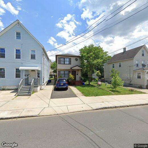
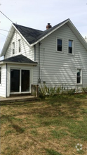
304 Pershing Ave
Carteret, NJ 07008
1 Day Ago
Favorites
732-634-9100
-
Bedrooms
2
-
Bathrooms
1.5
-
Square Feet
960 sq ft
-
Available
Available Now
Highlights
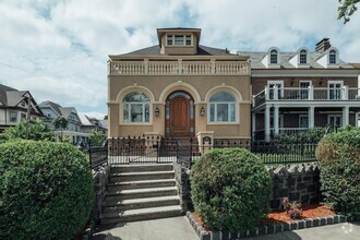
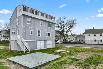
- Colonial Architecture
- Attic
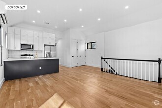
- Eat-In Kitchen
- Living Room
- Ceramic Tile Flooring
- Forced Air Heating System
304 Pershing Ave

Favorites
304 Pershing Ave is a house located in Middlesex County and the 07008 ZIP Code. This area is served by the Carteret Public attendance zone.
* Price shown is base rent and may not include non-optional fees and utilities.
Price, availability, fees, and any applicable rent special are subject to change without notice.
* Square footage definitions vary. Displayed square footage is approximate.
Home Details
Home Type
Single Family Detached Home
Year Built
Built in 1990
Basement
Basement Fills Entire Space Under The House
Laundry in Basement
Bedrooms and Bathrooms
1.5 Bathrooms
2 Bedrooms
Flooring
Ceramic Tile
Laminate
Home Design
Colonial Architecture
Interior Spaces
Living Room
960 Sq Ft Home
3-Story Property
Kitchen
Eat-In Kitchen
Gas Oven or Range
Listing and Financial Details
Tenant pays for repairs, grounds care, all utilities, electricity, gas, snow removal, hot water, trash collection, water
Utilities
Forced Air Heating System
Gas Water Heater
Underground Utilities
Community Details
Overview
The community has rules related to vehicle restrictions
Pershing Subdivision
Pet Policy
No Pets Allowed
Fees and Policies
Details
Lease Options
-
12 Months
Contact
- Listed by SUKHWINDER KAUR
- Phone Number (732) 634-9100
- Contact
-
Source
 CENTRAL JERSEY MULTIPLE LISTING SYSTEM, INC
The CENTRAL JERSEY MULTIPLE LISTING SYSTEM, INC does not warrant the accuracy, quality, reliability, suitability, completeness, usefulness or effectiveness of any information provided. The information being provided is for consumers' personal, non-commercial use and may not be used for any purpose other than to identify properties the consumer may be interested in purchasing or renting. Copyright 2025, CENTRAL JERSEY MULTIPLE LISTING SYSTEM, INC. All rights reserved. “The CENTRAL JERSEY MULTIPLE LISTING SYSTEM, INC retains all rights, title and interest in and to its trademarks, service marks and copyrighted material.
Location
Get Directions
Amenities
- Air Conditioning
- Kitchen
- Oven
- Range
- Refrigerator
- Tile Floors
- Vinyl Flooring
- Attic
Located directly across the Arthur Kill from Staten Island, Carteret was once part of the Woodbridge Township. It became the borough of Roosevelt in 1906 and was renamed Carteret in 1922. This popular community is bordered by the Rahway River to the north, Arthur Kill to the east, and the Ernest L. Oros Wildlife Preserve to the west. Due to its central location, the borough bills itself as the "Center of it All."
Residents enjoy a fantastic location and beautiful parks. Carteret Waterfront Park has a fishing pier and access to two hiking trails: Danielle's Garden Trail and the Waterfront Fitness Trail. Shopping in Carteret is plentiful -- the brick-paved sidewalks and outdoor cafes along Washington Avenue provide historic charm and locally-owned businesses, while the shops and restaurants along Roosevelt Avenue have a more modern feel. With just 22 miles to Manhattan, 10 miles to Newark, and 70 miles to Philadelphia, residents can easily commute to nearby cities.
Learn more about living in Carteret
Education
| Colleges & Universities | Distance | ||
|---|---|---|---|
| Colleges & Universities | Distance | ||
| Drive: | 14 min | 7.4 mi | |
| Drive: | 17 min | 9.0 mi | |
| Drive: | 18 min | 10.3 mi | |
| Drive: | 23 min | 13.2 mi |
304 Pershing Ave is within 14 minutes or 7.4 miles from Union County Coll., Elizabeth. It is also near Kean University and Coll. of Staten Island, CUNY.
Schools
Public Elementary School
Grades 5-6
553 Students
Attendance Zone
4
Out of 10
Public Elementary School
Grades PK-4
438 Students
Attendance Zone
2
Out of 10
Public High School
Grades 9-12
1,089 Students
Attendance Zone
2
Out of 10
Private Elementary, Middle & High School
40 Students
Nearby
Private Elementary School
Grades PK-5
Nearby
School data provided by
GreatSchools
The GreatSchools Rating helps parents compare schools within a state based on a variety of school quality indicators and provides a helpful picture of how effectively each school serves all of its students. Ratings are on a scale of 1 (below average) to 10 (above average) and can include test scores, college readiness, academic progress, advanced courses, equity, discipline and attendance data. We also advise parents to visit schools, consider other information on school performance and programs, and consider family needs as part of the school selection process.
Transportation options available in Carteret include 8Th Street Light Rail Station, located 11.9 miles from 304 Pershing Ave. 304 Pershing Ave is near Newark Liberty International, located 13.5 miles or 21 minutes away, and Laguardia, located 30.9 miles or 50 minutes away.
| Transit / Subway | Distance | ||
|---|---|---|---|
| Transit / Subway | Distance | ||
| Drive: | 20 min | 11.9 mi | |
|
|
Drive: | 22 min | 13.1 mi |
|
|
Drive: | 21 min | 14.8 mi |
|
|
Drive: | 20 min | 14.8 mi |
|
|
Drive: | 26 min | 16.9 mi |
| Commuter Rail | Distance | ||
|---|---|---|---|
| Commuter Rail | Distance | ||
|
|
Drive: | 9 min | 4.3 mi |
|
|
Drive: | 9 min | 4.7 mi |
|
|
Drive: | 10 min | 5.2 mi |
|
|
Drive: | 21 min | 11.2 mi |
|
|
Drive: | 23 min | 12.6 mi |
| Airports | Distance | ||
|---|---|---|---|
| Airports | Distance | ||
|
Newark Liberty International
|
Drive: | 21 min | 13.5 mi |
|
Laguardia
|
Drive: | 50 min | 30.9 mi |
Time and distance from 304 Pershing Ave.
| Shopping Centers | Distance | ||
|---|---|---|---|
| Shopping Centers | Distance | ||
| Walk: | 16 min | 0.8 mi | |
| Walk: | 19 min | 1.0 mi | |
| Drive: | 16 min | 9.7 mi |
304 Pershing Ave has 3 shopping centers within 9.7 miles, which is about a 16-minute drive. The miles and minutes will be for the farthest away property.
| Parks and Recreation | Distance | ||
|---|---|---|---|
| Parks and Recreation | Distance | ||
|
Liberty State Park
|
Drive: | 5 min | 1.9 mi |
|
Hawk Rise Sanctuary
|
Drive: | 12 min | 5.2 mi |
|
William T. Davis Wildlife Refuge
|
Drive: | 17 min | 10.5 mi |
|
Clay Pit Ponds State Park Preserve
|
Drive: | 22 min | 10.7 mi |
|
Freshkills Park
|
Drive: | 23 min | 13.4 mi |
304 Pershing Ave has 5 parks within 13.4 miles, including Liberty State Park, Hawk Rise Sanctuary, and William T. Davis Wildlife Refuge.
| Hospitals | Distance | ||
|---|---|---|---|
| Hospitals | Distance | ||
| Drive: | 12 min | 5.2 mi | |
| Drive: | 13 min | 7.1 mi | |
| Drive: | 14 min | 7.7 mi |
304 Pershing Ave has 3 hospitals within 7.7 miles, the nearest is Robert Wood Johnson University Hospital at Rahway which is 5.2 miles away and a 12 minutes drive.
| Military Bases | Distance | ||
|---|---|---|---|
| Military Bases | Distance | ||
| Drive: | 19 min | 8.2 mi | |
| Drive: | 22 min | 9.0 mi | |
| Drive: | 27 min | 14.9 mi |
304 Pershing Ave has 3 military bases within 14.9 miles, the nearest is Ash Brook Reservation which is 8.2 miles away and a 19 minutes .
You May Also Like
Similar Rentals Nearby
-
-
-
-
-
-
 $3,3002 Beds, 2 Baths, 1,506 sq ftHouse for Rent
 -
-
-
 $12,0005 Beds, 5 Baths, 3,500 sq ftHouse for Rent
 -
What Are Walk Score®, Transit Score®, and Bike Score® Ratings?
Walk Score® measures the walkability of any address. Transit Score® measures access to public transit. Bike Score® measures the bikeability of any address.
What is a Sound Score Rating?
A Sound Score Rating aggregates noise caused by vehicle traffic, airplane traffic and local sources

304 Pershing Ave
Carteret, NJ 07008