32 Cummins Hwy
32 Cummins Hwy,
Boston,
MA
02131
Favorites

32 Cummins Hwy
Favorites
Check Back Soon for Upcoming Availability
About 32 Cummins Hwy Boston, MA 02131
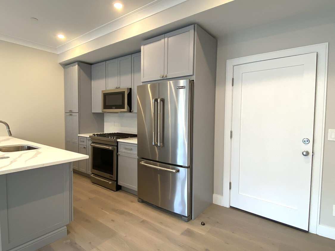
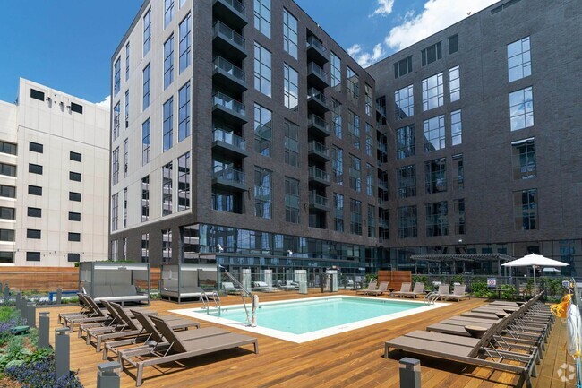
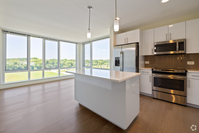
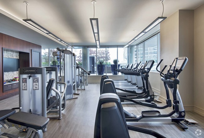
Absolutely incredible new construction in Roslindale. This unit features premium finishes from the bottom up. The kitchen features Jenn-Air appliances and quartz countertops. Bathrooms are perfectly designed with both stand-up shower (with built-in tile seat) as well as a full bath. In-unit laundry, a Juliet balcony, and custom closet shelving top off the finer details of this exquisite design.
32 Cummins Hwy is an apartment community located in Suffolk County and the 02131 ZIP Code.
Apartment Features
- Laundry Facilities
- Gated
Fees and Policies
The fees below are based on community-supplied data and may exclude additional fees and utilities.
- Parking
-
Street--
Details
Lease Options
-
12 Months
Property Address:
32 Cummins Hwy,
Boston,
MA
02131
 This Property
 Available Property
Lower Washington-Mount Hope is a walkable neighborhood about eight miles south of Boston via Interstate 93 or public transit. Despite this area’s dense population, Lower Washington-Mount Hope has many wooded areas, and large parks like Bussey Brook Meadow and Franklin Park surround the neighborhood. Along with residential neighborhoods, a few shops and eateries can be found in town along American Legion Highway. Many residents travel to the western corner of town to get to the shopping plaza off Corinth Street for all the necessities. The western part of the neighborhood is also where most of the rentals in this area are located. Apartments, condos, and townhomes ranging from moderately priced to luxury can be found here.
Learn more about living in Lower Washington-Mount HopeBelow are rent ranges for similar nearby apartments
| Beds | Average Size | Lowest | Typical | Premium |
|---|---|---|---|---|
| Studio Studio Studio | 621 Sq Ft | $2,095 | $2,300 | $2,423 |
| 1 Bed 1 Bed 1 Bed | 856 Sq Ft | $1,900 | $2,851 | $3,188 |
| 2 Beds 2 Beds 2 Beds | 1576 Sq Ft | $2,120 | $2,868 | $4,100 |
| 3 Beds 3 Beds 3 Beds | 1724 Sq Ft | $2,750 | $3,470 | $4,800 |
| 4 Beds 4 Beds 4 Beds | 6230 Sq Ft | $3,600 | $5,078 | $5,300 |
Amenities
- Laundry Facilities
- Gated
Education
| Colleges & Universities | Distance | ||
|---|---|---|---|
| Colleges & Universities | Distance | ||
| Drive: | 10 min | 3.9 mi | |
| Drive: | 10 min | 4.6 mi | |
| Drive: | 10 min | 5.0 mi | |
| Drive: | 10 min | 5.2 mi |
32 Cummins Hwy is within 10 minutes or 3.9 miles from Curry College. It is also near Wentworth Inst. of Technology and MCPHS University, Boston.
Transportation options available in Boston include Forest Hills Station, located 1.3 miles from 32 Cummins Hwy. 32 Cummins Hwy is near General Edward Lawrence Logan International, located 9.9 miles or 20 minutes away.
| Transit / Subway | Distance | ||
|---|---|---|---|
| Transit / Subway | Distance | ||
|
|
Drive: | 4 min | 1.3 mi |
|
|
Drive: | 6 min | 2.5 mi |
|
|
Drive: | 6 min | 2.6 mi |
|
|
Drive: | 7 min | 3.1 mi |
|
|
Drive: | 7 min | 3.1 mi |
| Commuter Rail | Distance | ||
|---|---|---|---|
| Commuter Rail | Distance | ||
|
|
Walk: | 5 min | 0.3 mi |
|
|
Drive: | 4 min | 1.2 mi |
|
|
Drive: | 4 min | 1.3 mi |
|
|
Drive: | 5 min | 1.7 mi |
|
|
Drive: | 7 min | 2.8 mi |
| Airports | Distance | ||
|---|---|---|---|
| Airports | Distance | ||
|
General Edward Lawrence Logan International
|
Drive: | 20 min | 9.9 mi |
Time and distance from 32 Cummins Hwy.
| Shopping Centers | Distance | ||
|---|---|---|---|
| Shopping Centers | Distance | ||
| Walk: | 20 min | 1.0 mi | |
| Drive: | 4 min | 1.3 mi | |
| Drive: | 4 min | 1.5 mi |
32 Cummins Hwy has 3 shopping centers within 1.5 miles, which is about a 4-minute drive. The miles and minutes will be for the farthest away property.
| Parks and Recreation | Distance | ||
|---|---|---|---|
| Parks and Recreation | Distance | ||
|
Arnold Arboretum of Harvard University
|
Drive: | 4 min | 1.4 mi |
|
Mass Audubon's Boston Nature Center and Wildlife Sanctuary
|
Drive: | 5 min | 1.7 mi |
|
Stony Brook Reservation
|
Drive: | 5 min | 2.2 mi |
|
Franklin Park Zoo
|
Drive: | 8 min | 3.6 mi |
|
Brook Farm Historic Site
|
Drive: | 8 min | 3.6 mi |
32 Cummins Hwy has 5 parks within 3.6 miles, including Arnold Arboretum of Harvard University, Mass Audubon's Boston Nature Center and Wildlife Sanctuary, and Stony Brook Reservation.
| Hospitals | Distance | ||
|---|---|---|---|
| Hospitals | Distance | ||
| Drive: | 4 min | 1.7 mi | |
| Drive: | 5 min | 2.1 mi | |
| Drive: | 7 min | 2.6 mi |
32 Cummins Hwy has 3 hospitals within 2.6 miles, the nearest is Brigham and Women's Faulkner Hospital which is 1.7 miles away and a 4 minutes drive.
| Military Bases | Distance | ||
|---|---|---|---|
| Military Bases | Distance | ||
| Drive: | 28 min | 15.0 mi |
32 Cummins Hwy is 15.0 miles and a 28 minutes from US Military Reservation.
You May Also Like
Similar Rentals Nearby


What Are Walk Score®, Transit Score®, and Bike Score® Ratings?
Walk Score® measures the walkability of any address. Transit Score® measures access to public transit. Bike Score® measures the bikeability of any address.
What is a Sound Score Rating?
A Sound Score Rating aggregates noise caused by vehicle traffic, airplane traffic and local sources