329 E 132nd St
329 E 132nd St,
The Bronx,
NY
10454
2 Weeks Ago
Favorites
329 E 132nd St

Favorites
Check Back Soon for Upcoming Availability
About 329 E 132nd St The Bronx, NY 10454
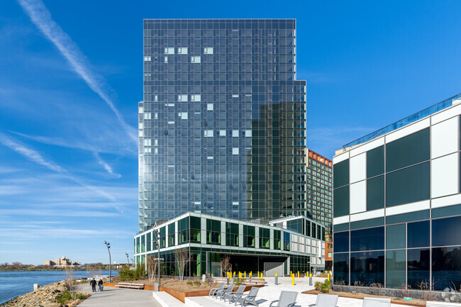
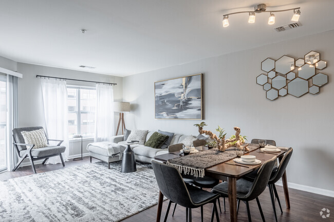
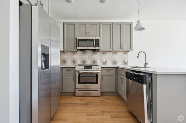
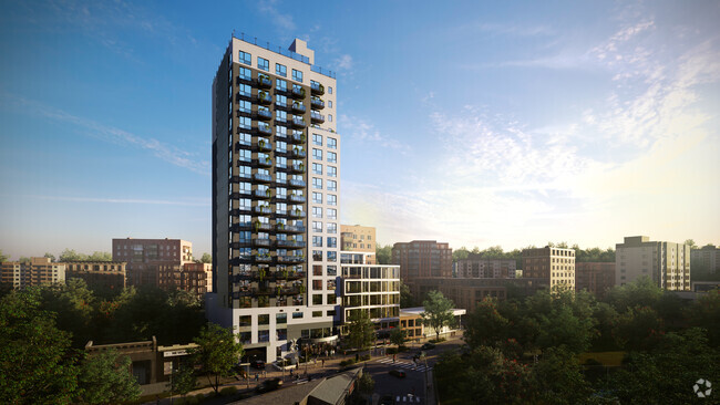
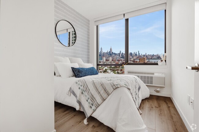
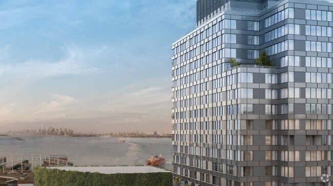
If youre looking for the convenience of an amenity-rich building paired with an authentic New York City neighborhood, look no further than Bridgeline, the Mott Haven neighborhoods newest residential building. Designed with the modern sophisticate in mind, this building offers residents a full-suite of luxury amenities. These include a stunning roof deck with panoramic views of the waterfront and Manhattan, a state-of-the-art fitness center, and resident lounges designed by Tersigni & Polachek. Sun-bathed residences are beautifully appointed with high-end appliances and sleek finishes. Located in one of the Bronx's most well-beloved areas just minutes away from Manhattan via the 4, 5, and 6 trains. Manhattan is also only a short bike ride away via the Third and Willis Avenue bridges and located amidst a series of new DOT bike routes leading to the Randals Island Connector. Bridgeline offers the best that contemporary city living has to offer.*Net effective rent advertised -Doorman -Garage -Laundry -Bicycle Room -Roof Deck -Virtual Doorman -City View
329 E 132nd St is an apartment community located in Bronx County and the 10454 ZIP Code.
Apartment Features
- Laundry Facilities
- Fitness Center
- Waterfront
Fees and Policies
The fees below are based on community-supplied data and may exclude additional fees and utilities.
- Dogs Allowed
-
Fees not specified
- Cats Allowed
-
Fees not specified
- Parking
-
Garage--
Details
Lease Options
-
12 Months
Location
Get Directions
The East and Harlem Rivers encircle Port Morris, an industrial-based waterfront neighborhood on the southwestern tip of the Bronx, New York. As the community's renaissance continues, residential construction adds to the supply of houses and condos for rent. Pulaski Park, a neighborhood recreational space and gathering place, offers exercise areas and basketball courts. Nearby highways give access to other city locations, including historic Harlem in Manhattan, just across the Harlem River.
Port Morris locals encourage their 90,000 neighbors to partake in community activities such as using the Randall's Island Connector to walk or bike to the island adjacent to the neighborhood. The Bronx Kill, a narrow stretch of water that connects the East and Harlem Rivers and separates Port Morris from Randall's Island, accommodates locals who canoe at high tide and walk across at low tide to get to the island.
Learn more about living in Port Morris
Amenities
- Laundry Facilities
- Waterfront
- Fitness Center
Education
| Colleges & Universities | Distance | ||
|---|---|---|---|
| Colleges & Universities | Distance | ||
| Drive: | 4 min | 1.4 mi | |
| Drive: | 6 min | 2.4 mi | |
| Drive: | 6 min | 2.5 mi | |
| Drive: | 7 min | 2.6 mi |
329 E 132nd St is within 4 minutes or 1.4 miles from Hostos Community College. It is also near The City College of New York and Manhattan School Of Music.
Transportation options available in The Bronx include 3 Avenue-138 Street, located 0.4 mile from 329 E 132nd St. 329 E 132nd St is near Laguardia, located 6.1 miles or 14 minutes away, and John F Kennedy International, located 17.3 miles or 27 minutes away.
| Transit / Subway | Distance | ||
|---|---|---|---|
| Transit / Subway | Distance | ||
|
|
Walk: | 8 min | 0.4 mi |
|
|
Walk: | 11 min | 0.6 mi |
|
|
Walk: | 13 min | 0.7 mi |
|
|
Walk: | 16 min | 0.9 mi |
|
|
Walk: | 18 min | 0.9 mi |
| Commuter Rail | Distance | ||
|---|---|---|---|
| Commuter Rail | Distance | ||
|
|
Walk: | 20 min | 1.0 mi |
|
|
Drive: | 4 min | 1.6 mi |
|
|
Drive: | 8 min | 2.4 mi |
| Drive: | 8 min | 3.2 mi | |
|
|
Drive: | 9 min | 4.5 mi |
| Airports | Distance | ||
|---|---|---|---|
| Airports | Distance | ||
|
Laguardia
|
Drive: | 14 min | 6.1 mi |
|
John F Kennedy International
|
Drive: | 27 min | 17.3 mi |
Time and distance from 329 E 132nd St.
| Shopping Centers | Distance | ||
|---|---|---|---|
| Shopping Centers | Distance | ||
| Drive: | 4 min | 1.2 mi | |
| Drive: | 4 min | 1.2 mi | |
| Drive: | 5 min | 1.9 mi |
329 E 132nd St has 3 shopping centers within 1.9 miles, which is about a 5-minute drive. The miles and minutes will be for the farthest away property.
| Parks and Recreation | Distance | ||
|---|---|---|---|
| Parks and Recreation | Distance | ||
|
St. Mary's Park
|
Drive: | 4 min | 1.2 mi |
|
Randall's Island Park
|
Drive: | 3 min | 1.3 mi |
|
Marcus Garvey Park
|
Drive: | 4 min | 1.3 mi |
|
Thomas Jefferson Park
|
Drive: | 5 min | 1.9 mi |
|
Mill Pond Park
|
Drive: | 6 min | 2.4 mi |
329 E 132nd St has 5 parks within 2.4 miles, including St. Mary's Park, Randall's Island Park, and Thomas Jefferson Park.
| Hospitals | Distance | ||
|---|---|---|---|
| Hospitals | Distance | ||
| Drive: | 4 min | 1.3 mi | |
| Drive: | 4 min | 1.4 mi | |
| Drive: | 6 min | 2.8 mi |
329 E 132nd St has 3 hospitals within 2.8 miles, the nearest is Lincoln Medical & Mental Health Center which is 1.3 miles away and a 4 minute drive.
| Military Bases | Distance | ||
|---|---|---|---|
| Military Bases | Distance | ||
| Drive: | 21 min | 11.0 mi | |
| Drive: | 24 min | 12.0 mi |
329 E 132nd St is 11.0 miles from Fort Totten US Govt Reservation, and is convenient to other military bases, including Governors Island Support Center.
You May Also Like
Similar Rentals Nearby


What Are Walk Score®, Transit Score®, and Bike Score® Ratings?
Walk Score® measures the walkability of any address. Transit Score® measures access to public transit. Bike Score® measures the bikeability of any address.
What is a Sound Score Rating?
A Sound Score Rating aggregates noise caused by vehicle traffic, airplane traffic and local sources