
$6,980 / Month
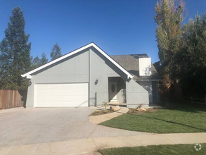
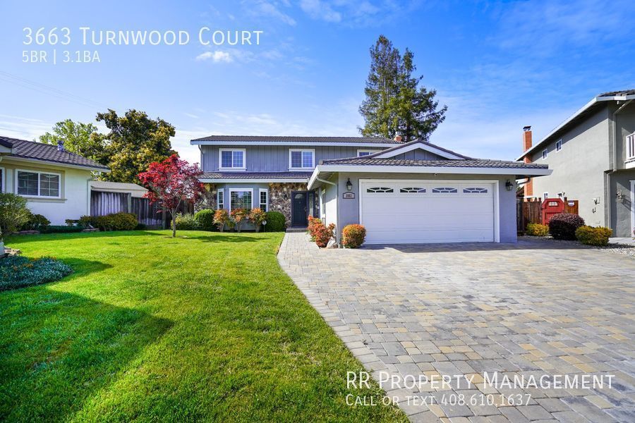
3663 Turnwood Ct
San Jose, CA 95130
2 Weeks Ago
Favorites
3663 Turnwood Ct

Favorites
Check Back Soon for Upcoming Availability
| Beds | Baths | Average SF |
|---|---|---|
| 5 Bedrooms 5 Bedrooms 5 Br | 3.5 Baths 3.5 Baths 3.5 Ba | 2,353 SF |
About This Property
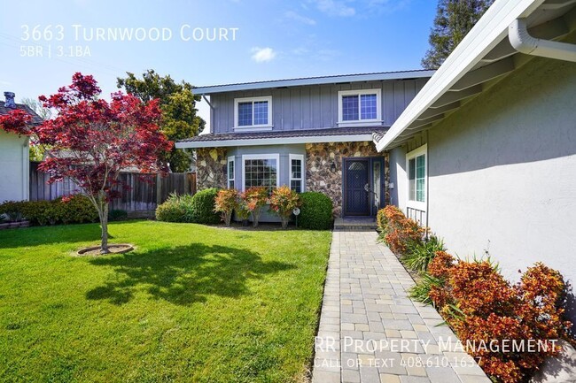
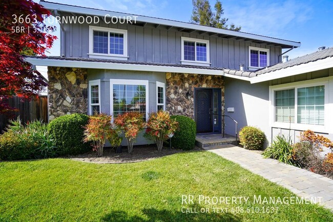
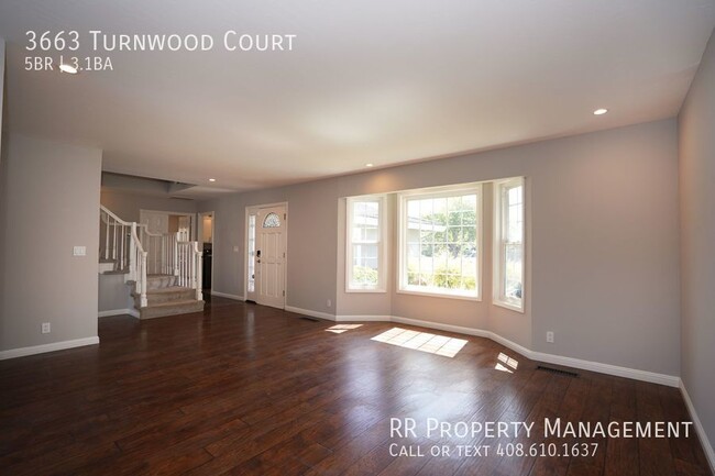
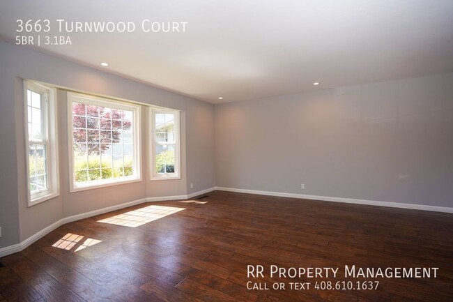
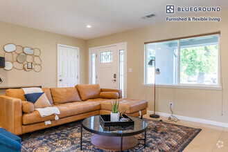
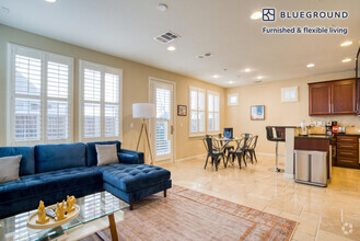
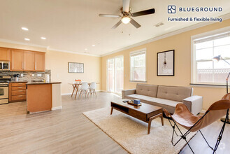
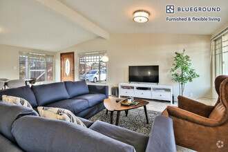
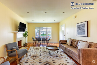
---- SCHEDULE A SHOWING ONLINE AT: ---- Your paradise retreat awaits! Come and see this spacious 5-bedroom, 3.5-bathroom, single family home in a fantastic central location in West San Jose. This two-story home features laminate flooring on the ground floor and lush carpeting in the bedrooms upstairs. Upgraded kitchen with quartz counters and stainless steel appliances with sliding door leading to your private backyard oasis. Separate family room with fireplace and sliding door to backyard. Ground floor suite, perfect for an office/guest room. Large primary bedroom upstairs with three additional bedrooms. Dual-pane windows, central heating and AC! Huge lot with a beautiful backyard including paver stone hardscaping with pool, outdoor BBQ, and firepit with conversation bench. Lawn area and mature trees and bushes line the perimeter, encompassing you in the seclusion of your backyard retreat! Walking distance to Payne Elementary. Nearby local shopping areas (Westgate/Valley Fair) with easy access to Lawrence/San Tomas Expwy, and highways 280/85, a commuter's dream! Available Now! Central Ac Dual Pane Windows Ground Floor Suite Laminate Wood Flooring Tile Flooring Two Car Garage Whole House Fan
3663 Turnwood Ct is a house located in Santa Clara County and the 95130 ZIP Code. This area is served by the Moreland attendance zone.
Location
Get Directions
Located just off the San Tomas Expressway, Paynes is a largely residential neighborhood containing educational and care facilities. All kinds of international cuisine are conveniently located near Paynes, including Filipino, Persian, and Latin American restaurants to satisfy even the most cultured eaters. Shoppers delight in Paynes’ close proximity to a host of retail centers such as the Westgate Center, Westgate West, and El Paseo de Saratoga trio in addition to Santana Row and Westfield Valley Fair. Outdoor enthusiasts relish access to both John D. Morgan Park and Hathaway Park from nearby Paynes.
Accessible to public transportation as well as Interstates 280 and 880, Paynes residents enjoy convenience to San Jose International Airport, Santa Clara University, and Downtown San Jose.
Learn more about living in PaynesBelow are rent ranges for similar nearby apartments
Education
| Colleges & Universities | Distance | ||
|---|---|---|---|
| Colleges & Universities | Distance | ||
| Drive: | 8 min | 3.6 mi | |
| Drive: | 12 min | 5.0 mi | |
| Drive: | 12 min | 5.2 mi | |
| Drive: | 14 min | 5.6 mi |
3663 Turnwood Ct is within 8 minutes or 3.6 miles from San Jose City College. It is also near West Valley College and Santa Clara University.
Schools


Public Elementary School
Grades K-5
367 Students
Nearby
Public Elementary School
Grades K-5
455 Students
Attendance Zone
Public Middle School
Grades 6-8
783 Students
Attendance Zone
Public High School
Grades 9-12
1,459 Students
Attendance Zone
Private Elementary, Middle & High School
Grades 1-12
6 Students
Nearby
Private Elementary, Middle & High School
Grades K-10
22 Students
Nearby
Private Elementary School
Grades PK-5
Nearby
Private Elementary & Middle School
Grades PK-8
498 Students
Nearby
School data provided by
 The GreatSchools Rating helps parents compare schools within a state based on a variety of school quality indicators and provides a helpful picture of how effectively each school serves all of its students. Ratings are on a scale of 1 (below average) to 10 (above average) and can include test scores, college readiness, academic progress, advanced courses, equity, discipline and attendance data. We also advise parents to visit schools, consider other information on school performance and programs, and consider family needs as part of the school selection process.
View GreatSchools Rating Methodology
View GreatSchools Rating Methodology
Transportation options available in San Jose include Hamilton Station, located 1.9 miles from 3663 Turnwood Ct. 3663 Turnwood Ct is near Norman Y Mineta San Jose International, located 5.7 miles or 12 minutes away, and San Francisco International, located 36.7 miles or 48 minutes away.
| Transit / Subway | Distance | ||
|---|---|---|---|
| Transit / Subway | Distance | ||
|
|
Drive: | 4 min | 1.9 mi |
|
|
Drive: | 5 min | 2.1 mi |
|
|
Drive: | 6 min | 2.3 mi |
|
|
Drive: | 7 min | 2.8 mi |
|
|
Drive: | 7 min | 3.7 mi |
| Commuter Rail | Distance | ||
|---|---|---|---|
| Commuter Rail | Distance | ||
| Drive: | 10 min | 5.0 mi | |
| Drive: | 12 min | 5.8 mi | |
| Drive: | 13 min | 6.6 mi | |
| Drive: | 12 min | 6.7 mi | |
| Drive: | 13 min | 7.0 mi |
| Airports | Distance | ||
|---|---|---|---|
| Airports | Distance | ||
|
Norman Y Mineta San Jose International
|
Drive: | 12 min | 5.7 mi |
|
San Francisco International
|
Drive: | 48 min | 36.7 mi |
Time and distance from 3663 Turnwood Ct.
| Shopping Centers | Distance | ||
|---|---|---|---|
| Shopping Centers | Distance | ||
| Walk: | 8 min | 0.5 mi | |
| Walk: | 10 min | 0.5 mi | |
| Walk: | 14 min | 0.7 mi |
3663 Turnwood Ct has 3 shopping centers within 0.7 mile, which is about a 14-minute walk. The miles and minutes will be for the farthest away property.
| Parks and Recreation | Distance | ||
|---|---|---|---|
| Parks and Recreation | Distance | ||
|
John D. Morgan Park
|
Drive: | 4 min | 1.8 mi |
|
Orchard City Green
|
Drive: | 5 min | 2.3 mi |
|
Los Gatos Creek Trail
|
Drive: | 5 min | 2.7 mi |
|
Edith Morley Park
|
Drive: | 7 min | 3.4 mi |
|
Jack Fischer Park
|
Drive: | 8 min | 3.5 mi |
3663 Turnwood Ct has 5 parks within 3.5 miles, including John D. Morgan Park, Orchard City Green, and Los Gatos Creek Trail.
| Hospitals | Distance | ||
|---|---|---|---|
| Hospitals | Distance | ||
| Drive: | 6 min | 3.3 mi | |
| Drive: | 8 min | 4.4 mi | |
| Drive: | 9 min | 4.5 mi |
3663 Turnwood Ct has 3 hospitals within 4.5 miles, the nearest is Santa Clara Valley Medical Center which is 3.3 miles away and a 6 minute drive.
| Military Bases | Distance | ||
|---|---|---|---|
| Military Bases | Distance | ||
| Drive: | 23 min | 13.7 mi |
3663 Turnwood Ct is 13.7 miles and a 23 minute drive from Ames Research Center.
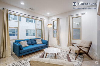
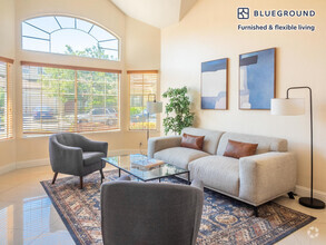
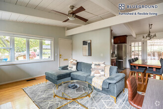
You May Also Like
Similar Rentals Nearby

What Are Walk Score®, Transit Score®, and Bike Score® Ratings?
Walk Score® measures the walkability of any address. Transit Score® measures access to public transit. Bike Score® measures the bikeability of any address.
What is a Sound Score Rating?
A Sound Score Rating aggregates noise caused by vehicle traffic, airplane traffic and local sources
3663 Turnwood Ct
San Jose, CA 95130