
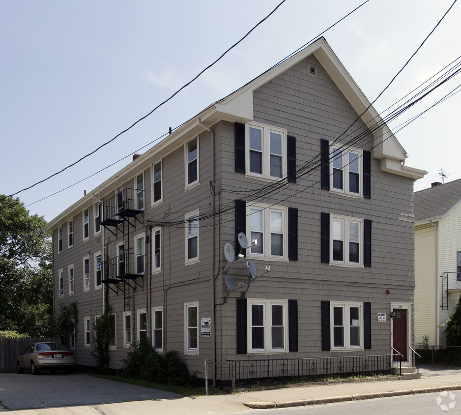
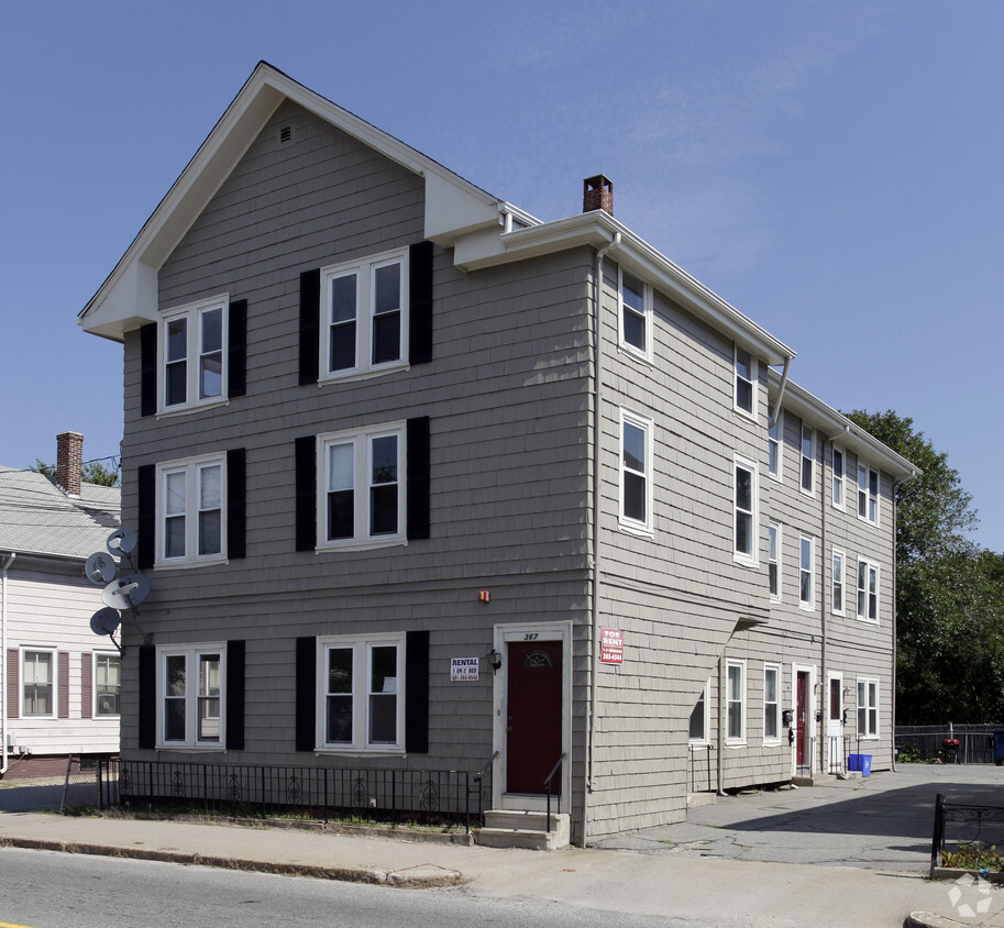
367 Broad St
367 Broad St,
Cumberland,
RI
02864
2 Weeks Ago
Favorites
367 Broad St
Favorites
Check Back Soon for Upcoming Availability
| Beds | Baths | Average SF | Availability |
|---|---|---|---|
| 1 Bedroom 1 Bedroom 1 Br | 1 Bath 1 Bath 1 Ba | — | Not Available |
About 367 Broad St Cumberland, RI 02864
Find your new home at 367 Broad St in Cumberland, RI. Based in Cumberland's 02864 Zip code, moving here gives you a number of nearby experiences. Come for a visit to see the current floorplan options. The leasing staff is ready for you to come by for a visit. Stop by 367 Broad St today.
367 Broad St is an apartment community located in Providence County and the 02864 ZIP Code. This area is served by the Cumberland attendance zone.
Fees and Policies
Details
Property Information
-
Built in 1930
-
6 units/3 stories
Location
Get Directions
Cumberland is a charming city in northeast Rhode Island. The city’s historical significance runs deep and is remembered today through the Monastery, a historical home for monks in the 19th century. This unique property resides on about 481 acres and now houses the Cumberland Public Library. Recreational trails were developed by the monks at the Monastery, known as the Nine Men’s Misery. Parks, ponds, and reservoirs are plentiful in the area, and more nature trails are available to the public, such as Diamond Hill Park Trail. Local pizza restaurants are abundant in the community, as well as a good variety of other cuisines like Angelo’s Palace Pizza and Davenport’s on Mendon Road. This family-friendly city is zoned into Cumberland Schools with a great variety of public schools for the residential youth.
Learn more about living in Cumberland
Education
| Colleges & Universities | Distance | ||
|---|---|---|---|
| Colleges & Universities | Distance | ||
| Drive: | 10 min | 4.2 mi | |
| Drive: | 12 min | 5.9 mi | |
| Drive: | 11 min | 6.3 mi | |
| Drive: | 11 min | 7.3 mi |
367 Broad St is within 10 minutes or 4.2 miles from C.C. of Rhode Island, Flanagan. It is also near Brown University and Rhode Island School of Design.
Schools


Public Elementary School
Grades PK-1
Nearby
Public Elementary School
Grades K-5
296 Students
Nearby
Public Elementary School
Grades K-5
323 Students
Attendance Zone
Public Middle School
Grades 6-8
436 Students
Attendance Zone
Public High School
Grades 9-12
811 Students
Nearby
Public High School
Grades 9-12
1,446 Students
Attendance Zone
Private Elementary & Middle School
Grades PK-8
160 Students
Nearby
Private Elementary, Middle & High School
Grades 1-12
24 Students
Nearby
School data provided by
 The GreatSchools Rating helps parents compare schools within a state based on a variety of school quality indicators and provides a helpful picture of how effectively each school serves all of its students. Ratings are on a scale of 1 (below average) to 10 (above average) and can include test scores, college readiness, academic progress, advanced courses, equity, discipline and attendance data. We also advise parents to visit schools, consider other information on school performance and programs, and consider family needs as part of the school selection process.
View GreatSchools Rating Methodology
View GreatSchools Rating Methodology
Transportation options available in Cumberland include Mattapan Station, located 33.4 miles from 367 Broad St. 367 Broad St is near Rhode Island Tf Green International, located 15.4 miles or 27 minutes away, and Worcester Regional, located 41.3 miles or 55 minutes away.
| Transit / Subway | Distance | ||
|---|---|---|---|
| Transit / Subway | Distance | ||
|
|
Drive: | 46 min | 33.4 mi |
|
|
Drive: | 47 min | 33.8 mi |
|
|
Drive: | 47 min | 33.9 mi |
|
|
Drive: | 49 min | 35.6 mi |
|
|
Drive: | 52 min | 38.7 mi |
| Commuter Rail | Distance | ||
|---|---|---|---|
| Commuter Rail | Distance | ||
| Drive: | 3 min | 2.3 mi | |
|
|
Drive: | 6 min | 3.0 mi |
|
|
Drive: | 11 min | 6.6 mi |
|
|
Drive: | 11 min | 7.3 mi |
|
|
Drive: | 23 min | 13.7 mi |
| Airports | Distance | ||
|---|---|---|---|
| Airports | Distance | ||
|
Rhode Island Tf Green International
|
Drive: | 27 min | 15.4 mi |
|
Worcester Regional
|
Drive: | 55 min | 41.3 mi |
Time and distance from 367 Broad St.
| Shopping Centers | Distance | ||
|---|---|---|---|
| Shopping Centers | Distance | ||
| Walk: | 17 min | 0.9 mi | |
| Walk: | 19 min | 1.0 mi | |
| Drive: | 4 min | 2.3 mi |
367 Broad St has 3 shopping centers within 2.3 miles, which is about a 4-minute walk. The miles and minutes will be for the farthest away property.
| Parks and Recreation | Distance | ||
|---|---|---|---|
| Parks and Recreation | Distance | ||
|
Blackstone Valley Outfitters
|
Walk: | 19 min | 1.0 mi |
|
Lincoln Woods State Park
|
Drive: | 5 min | 2.3 mi |
|
Ladd Observatory
|
Drive: | 10 min | 5.1 mi |
|
Caratunk Wildlife Refuge
|
Drive: | 12 min | 6.3 mi |
|
Blackstone River Bikeway
|
Drive: | 12 min | 6.9 mi |
367 Broad St has 5 parks within 6.9 miles, including Blackstone Valley Outfitters, Lincoln Woods State Park, and Blackstone River Bikeway.
| Hospitals | Distance | ||
|---|---|---|---|
| Hospitals | Distance | ||
| Drive: | 5 min | 2.8 mi | |
| Drive: | 7 min | 4.4 mi | |
| Drive: | 8 min | 4.6 mi |
367 Broad St has 3 hospitals within 4.6 miles, the nearest is Arbour - Fuller Hospital which is 2.8 miles away and a 5 minute drive.
| Military Bases | Distance | ||
|---|---|---|---|
| Military Bases | Distance | ||
| Drive: | 42 min | 27.7 mi | |
| Drive: | 55 min | 30.6 mi |
367 Broad St is 27.7 miles from Rhode Island National Gaurd, and is convenient to other military bases, including US Military Reservation.
You May Also Like
Similar Rentals Nearby


What Are Walk Score®, Transit Score®, and Bike Score® Ratings?
Walk Score® measures the walkability of any address. Transit Score® measures access to public transit. Bike Score® measures the bikeability of any address.
What is a Sound Score Rating?
A Sound Score Rating aggregates noise caused by vehicle traffic, airplane traffic and local sources
367 Broad St
Cumberland, RI 02864
Responded To This Review