
$8,000 / Month
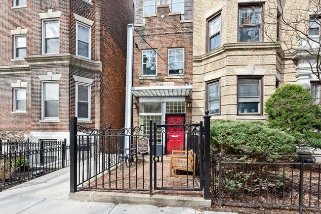
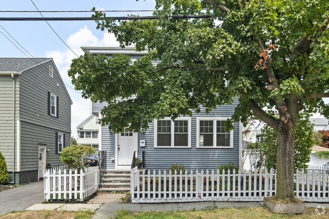
37 Queensberry St
Boston, MA 02215
Today
Favorites
617-285-7100
-
Bedrooms
4
-
Bathrooms
3
-
Square Feet
2,440 sq ft
-
Available
Available Now
Highlights
- Medical Services
- Deck
- Property is near public transit
- Jogging Path
- Cooling Available
- Park
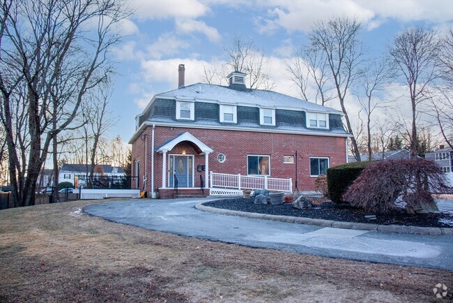
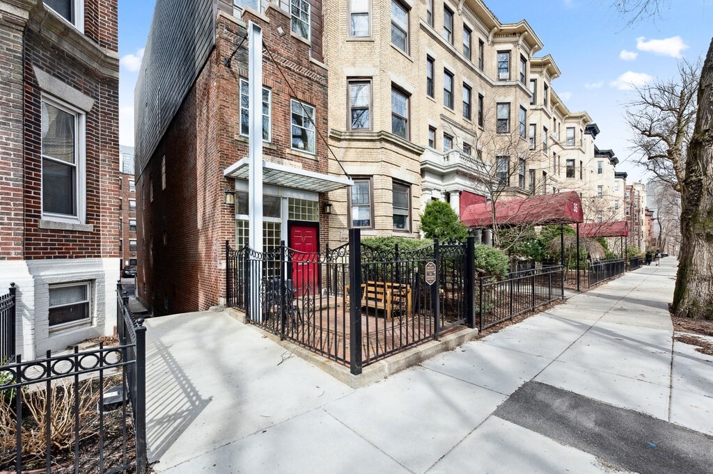
37 Queensberry St

Favorites
About This Home
$8,000 deposit,
Available Now
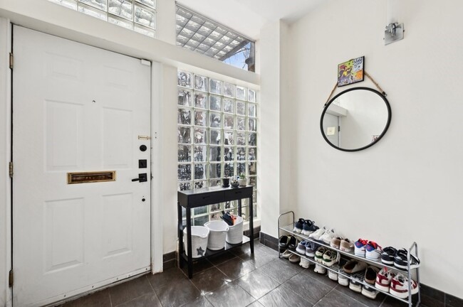
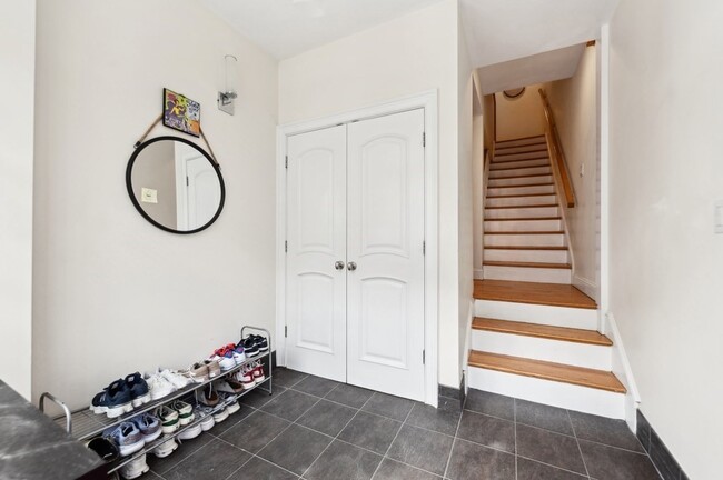
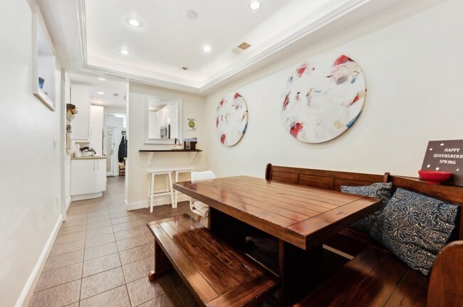
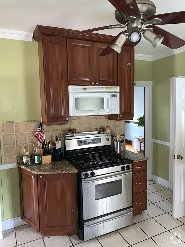
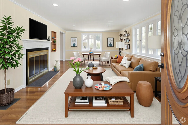
Welcome to The Pantry,this charming single-family home nestled in the vibrant Fenway neighborhood. As you enter,you'll be greeted by an inviting atmosphere with a seamless flow throughout the main level. The home features four well proportioned bedrooms,each providing a comfortable retreat for rest and rejuvenation. With two full and two 1/2 well-appointed bathrooms,convenience and privacy are effortlessly achieved for everyone in the household. The kitchen is designed for both functionality and style,offering plenty of space for culinary creativity. Adjacent to the kitchen,you'll find a dining area that enhances the home's open-concept design. Natural light floods the interior,accentuating the home's warm and welcoming ambiance. The property also boasts central heat & A/C,laundry,2 outdoor spaces and parking for 2 cars. Outside,enjoy the benefits of urban living with nearby amenities that cater to a variety of interests and lifestyles. Available 9/1.
37 Queensberry St is a house located in Suffolk County and the 02215 ZIP Code. This area is served by the Boston Public Schools attendance zone.
* Price shown is base rent and may not include non-optional fees and utilities.
Price, availability, fees, and any applicable rent special are subject to change without notice.
* Square footage definitions vary. Displayed square footage is approximate.
Home Details
Home Type
Single Family Detached Home
Year Built
Built in 1920
Accessible Home Design
Entry on the 3rd floor
Bedrooms and Bathrooms
4 Bathrooms
4 Bedrooms
Interior Spaces
2,440 Sq Ft Home
Kitchen
Range
Freezer
Dishwasher
Laundry
Dryer
Laundry in unit
Washer
Listing and Financial Details
Security Deposit $8,000
Property Available on 9/1/25
12 Month Lease Term
Assessor Parcel Number 3363315
Rent includes water, sewer
Location
Property is near public transit
Property is near schools
Lot Details
2.3 Acre Lot
Outdoor Features
Deck
Parking
2 Car Parking Spaces
Schools
Bps Elementary And Middle School
Bps High School
Utilities
Cooling Available
Central Heating
Community Details
Amenities
Medical Services
Shops
Laundry Facilities
Overview
No Home Owners Association
Pet Policy
Call for details about the types of pets allowed
Recreation
Jogging Path
Park
Contact
- Listed by Nicole Modica | Compass
- Phone Number
-
Source
 MLS Property Information Network
The property listing data and information set forth herein were provided to MLS Property Information Network, Inc. from third party sources, including sellers, lessors and public records, and were compiled by MLS Property Information Network, Inc. The property listing data and information are for the personal, non-commercial use of consumers having a good faith interest in purchasing or leasing listed properties of the type displayed to them and may not be used for any purpose other than to identify prospective properties which such consumers may have a good faith interest in purchasing or leasing. MLS Property Information Network, Inc. and its subscribers disclaim any and all representations and warranties as to the accuracy of the property listing data and information set forth herein. All properties are subject to prior sale, change or withdrawal. Copyright © 2025 MLS Property Information Network, Inc. All rights reserved.
Location
Get Directions
Amenities
- Dishwasher
- Range
- Refrigerator
- Freezer
- Deck
Tree-filled, historic, and packed with educational opportunity, there's no other neighborhood quite like Fenway. The neighborhood may be most well-known for its titular attraction, Fenway Park, home of the Boston Red Sox. However, the area is also renowned for its sprawling greenspace. The name "Fenway" refers to the neighborhood’s lush parkway and tree-filled paths that wind lazily through the area, forming part of Frederick Law Olmsted’s “Emerald Necklace Plan” (a chain of parks throughout Boston). The Fenway opened in 1876, and its route includes the Museum of Fine Arts and the Isabella Steward Gardner Museum.
Learn more about living in Fenway
Education
| Colleges & Universities | Distance | ||
|---|---|---|---|
| Colleges & Universities | Distance | ||
| Walk: | 11 min | 0.6 mi | |
| Walk: | 11 min | 0.6 mi | |
| Drive: | 3 min | 1.1 mi | |
| Drive: | 3 min | 1.2 mi |
37 Queensberry St is within 3 minutes or 1.1 miles from Simmons College. It is also near Emmanuel College and Wentworth Inst. of Technology.
Schools


Public Elementary & Middle School
Grades PK-8
426 Students
Attendance Zone
Public Elementary & Middle School
Grades PK-8
352 Students
Attendance Zone
Public Middle & High School
Grades 7-12
2,423 Students
Attendance Zone
Public Middle & High School
Grades 7-12
26 Students
Attendance Zone
Charter High School
Grades 9-12
364 Students
Attendance Zone
Private Elementary, Middle & High School
Grades 5-12
471 Students
Nearby
Private Elementary School
Grades PK-6
202 Students
Nearby
School data provided by
 The GreatSchools Rating helps parents compare schools within a state based on a variety of school quality indicators and provides a helpful picture of how effectively each school serves all of its students. Ratings are on a scale of 1 (below average) to 10 (above average) and can include test scores, college readiness, academic progress, advanced courses, equity, discipline and attendance data. We also advise parents to visit schools, consider other information on school performance and programs, and consider family needs as part of the school selection process.
View GreatSchools Rating Methodology
View GreatSchools Rating Methodology
Transportation options available in Boston include Museum Of Fine Arts Station, located 0.5 mile from 37 Queensberry St. 37 Queensberry St is near General Edward Lawrence Logan International, located 6.4 miles or 14 minutes away.
| Transit / Subway | Distance | ||
|---|---|---|---|
| Transit / Subway | Distance | ||
|
|
Walk: | 10 min | 0.5 mi |
|
|
Walk: | 10 min | 0.5 mi |
|
|
Walk: | 10 min | 0.5 mi |
|
|
Walk: | 11 min | 0.6 mi |
|
|
Drive: | 4 min | 1.5 mi |
| Commuter Rail | Distance | ||
|---|---|---|---|
| Commuter Rail | Distance | ||
|
|
Walk: | 15 min | 0.8 mi |
|
|
Drive: | 7 min | 1.7 mi |
| Drive: | 5 min | 2.2 mi | |
|
|
Drive: | 7 min | 2.8 mi |
|
|
Drive: | 8 min | 4.1 mi |
| Airports | Distance | ||
|---|---|---|---|
| Airports | Distance | ||
|
General Edward Lawrence Logan International
|
Drive: | 14 min | 6.4 mi |
Time and distance from 37 Queensberry St.
| Shopping Centers | Distance | ||
|---|---|---|---|
| Shopping Centers | Distance | ||
| Walk: | 7 min | 0.4 mi | |
| Drive: | 3 min | 1.1 mi | |
| Drive: | 9 min | 5.0 mi |
37 Queensberry St has 3 shopping centers within 5.0 miles, which is about a 9-minute walk. The miles and minutes will be for the farthest away property.
| Parks and Recreation | Distance | ||
|---|---|---|---|
| Parks and Recreation | Distance | ||
|
Charles River Reservation
|
Drive: | 3 min | 1.4 mi |
|
Coit Observatory
|
Drive: | 4 min | 1.8 mi |
|
Boston Public Garden
|
Drive: | 6 min | 2.0 mi |
|
Roxbury Heritage State Park
|
Drive: | 5 min | 2.0 mi |
|
John Fitzgerald Kennedy National Historic Site
|
Drive: | 5 min | 2.3 mi |
37 Queensberry St has 5 parks within 2.3 miles, including Charles River Reservation, Coit Observatory, and Roxbury Heritage State Park.
| Hospitals | Distance | ||
|---|---|---|---|
| Hospitals | Distance | ||
| Walk: | 11 min | 0.6 mi | |
| Drive: | 3 min | 1.2 mi | |
| Drive: | 3 min | 1.6 mi |
37 Queensberry St has 3 hospitals within 1.6 miles, the nearest is Beth Israel Deaconess Medical Center which is 0.6 mile away and a 11 minute walk.
| Military Bases | Distance | ||
|---|---|---|---|
| Military Bases | Distance | ||
| Drive: | 30 min | 15.1 mi | |
| Drive: | 29 min | 16.1 mi |
37 Queensberry St is 15.1 miles from Hanscom Air Force Base, and is convenient to other military bases, including US Military Reservation.
You May Also Like
Similar Rentals Nearby


What Are Walk Score®, Transit Score®, and Bike Score® Ratings?
Walk Score® measures the walkability of any address. Transit Score® measures access to public transit. Bike Score® measures the bikeability of any address.
What is a Sound Score Rating?
A Sound Score Rating aggregates noise caused by vehicle traffic, airplane traffic and local sources
37 Queensberry St
Boston, MA 02215