
$5,200 / Month
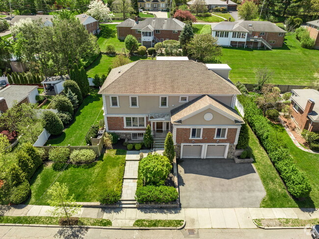
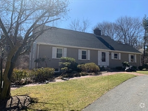
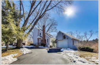
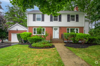
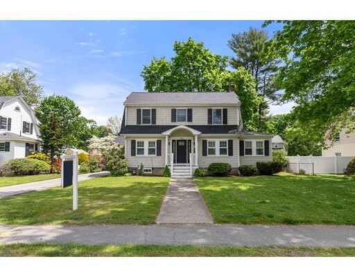
395 Weston Rd
Wellesley, MA 02482
2 Weeks Ago
Favorites
395 Weston Rd

Favorites
Check Back Soon for Upcoming Availability
| Beds | Baths | Average SF |
|---|---|---|
| 3 Bedrooms 3 Bedrooms 3 Br | 1.5 Baths 1.5 Baths 1.5 Ba | 2,125 SF |
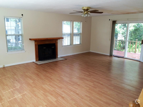
About This Property
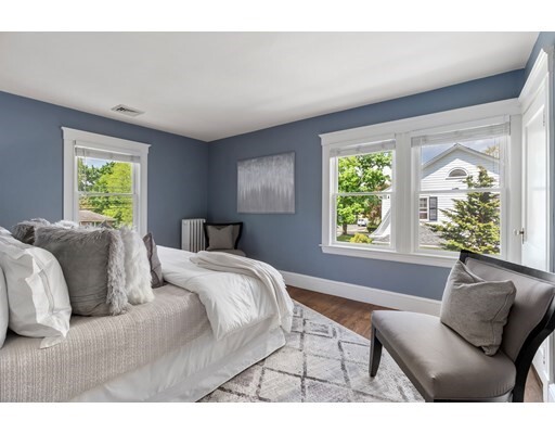
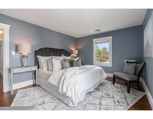
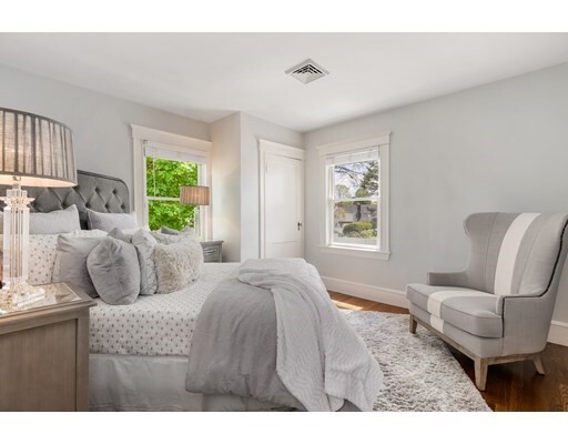
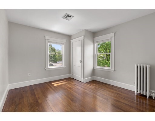
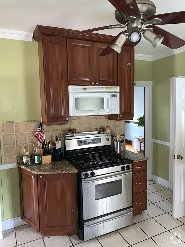
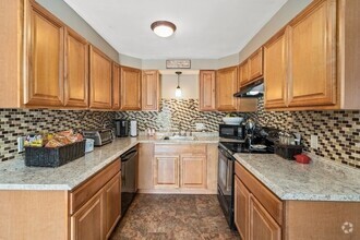
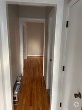
Beautiful 3 bedroom colonial close to Perrin Park, Kelly memorial park, Wellesley Square, primary school and Wellesley College. On the first floor, there is updated Kitchen with stainless steel appliances, gas cooktop, double oven, wine cooler connecting with a cozy dining area, spacious living rm with fireplace to sunny family room .The three nice size bedrooms with one full bath w/double and a den make up the second level. Finished lower level with recess light has family space for play and exercise. Nice level backyard give an idyllic feeling, plus there is a detached garage with new garage door installed in 2022.
395 Weston Rd is a house located in Norfolk County and the 02482 ZIP Code. This area is served by the Wellesley attendance zone.
House Features
Air Conditioning
Dishwasher
Microwave
Refrigerator
- Air Conditioning
- Dishwasher
- Disposal
- Microwave
- Oven
- Range
- Refrigerator
- Patio
Fees and Policies
The fees below are based on community-supplied data and may exclude additional fees and utilities.
Location
Get Directions
Just west of Boston and East of Worcester sits Metro West, a region that houses a group of towns and cities with significant historical backgrounds. A total of 19 municipalities make up the core of this community, but other municipalities are considered to be a part of the Interstate 495/Metro West Corridor.
Learn more about living in Metro WestBelow are rent ranges for similar nearby apartments
| Beds | Average Size | Lowest | Typical | Premium |
|---|---|---|---|---|
| Studio Studio Studio | 533-536 Sq Ft | $1,450 | $2,541 | $6,803 |
| 1 Bed 1 Bed 1 Bed | 792-793 Sq Ft | $1,050 | $3,047 | $10,781 |
| 2 Beds 2 Beds 2 Beds | 1162-1164 Sq Ft | $1,850 | $3,678 | $15,521 |
| 3 Beds 3 Beds 3 Beds | 1590-1595 Sq Ft | $2,190 | $5,139 | $20,680 |
| 4 Beds 4 Beds 4 Beds | 3416 Sq Ft | $1,050 | $6,448 | $20,000 |
Amenities
- Air Conditioning
- Dishwasher
- Disposal
- Microwave
- Oven
- Range
- Refrigerator
- Patio
Education
| Colleges & Universities | Distance | ||
|---|---|---|---|
| Colleges & Universities | Distance | ||
| Drive: | 6 min | 2.4 mi | |
| Drive: | 7 min | 3.4 mi | |
| Drive: | 13 min | 6.6 mi | |
| Drive: | 12 min | 6.9 mi |
395 Weston Rd is within 6 minutes or 2.4 miles from Wellesley College. It is also near Babson College and Brandeis University.
Schools


Public Elementary School
Grades K-5
271 Students
Attendance Zone
Public Elementary School
Grades K-5
280 Students
Nearby
Public Middle School
Grades 6-8
922 Students
Attendance Zone
Public High School
Grades 9-12
1,412 Students
Attendance Zone
Private Elementary & Middle School
Grades PK-8
185 Students
Nearby
Private Middle & High School
Grades 6-12
496 Students
Nearby
School data provided by
 The GreatSchools Rating helps parents compare schools within a state based on a variety of school quality indicators and provides a helpful picture of how effectively each school serves all of its students. Ratings are on a scale of 1 (below average) to 10 (above average) and can include test scores, college readiness, academic progress, advanced courses, equity, discipline and attendance data. We also advise parents to visit schools, consider other information on school performance and programs, and consider family needs as part of the school selection process.
View GreatSchools Rating Methodology
View GreatSchools Rating Methodology
Transportation options available in Wellesley include Woodland Station, located 4.9 miles from 395 Weston Rd. 395 Weston Rd is near General Edward Lawrence Logan International, located 18.9 miles or 31 minutes away, and Worcester Regional, located 30.9 miles or 52 minutes away.
| Transit / Subway | Distance | ||
|---|---|---|---|
| Transit / Subway | Distance | ||
|
|
Drive: | 9 min | 4.9 mi |
|
|
Drive: | 10 min | 5.0 mi |
|
|
Drive: | 10 min | 5.6 mi |
|
|
Drive: | 11 min | 6.2 mi |
|
|
Drive: | 11 min | 6.4 mi |
| Commuter Rail | Distance | ||
|---|---|---|---|
| Commuter Rail | Distance | ||
|
|
Drive: | 3 min | 1.7 mi |
|
|
Drive: | 5 min | 2.9 mi |
|
|
Drive: | 7 min | 3.7 mi |
|
|
Drive: | 7 min | 4.2 mi |
|
|
Drive: | 10 min | 5.1 mi |
| Airports | Distance | ||
|---|---|---|---|
| Airports | Distance | ||
|
General Edward Lawrence Logan International
|
Drive: | 31 min | 18.9 mi |
|
Worcester Regional
|
Drive: | 52 min | 30.9 mi |
Time and distance from 395 Weston Rd.
| Shopping Centers | Distance | ||
|---|---|---|---|
| Shopping Centers | Distance | ||
| Drive: | 2 min | 1.6 mi | |
| Drive: | 4 min | 1.9 mi | |
| Drive: | 4 min | 2.2 mi |
395 Weston Rd has 3 shopping centers within 2.2 miles, which is about a 4-minute drive. The miles and minutes will be for the farthest away property.
| Parks and Recreation | Distance | ||
|---|---|---|---|
| Parks and Recreation | Distance | ||
|
Whitin Observatory
|
Drive: | 4 min | 1.6 mi |
|
Wellesley College Botanic Gardens
|
Drive: | 3 min | 1.9 mi |
|
Elm Bank Reservation
|
Drive: | 9 min | 3.7 mi |
|
Hamlen Woods
|
Drive: | 7 min | 3.9 mi |
|
Horticultural Society at Elm Bank
|
Drive: | 10 min | 3.9 mi |
395 Weston Rd has 5 parks within 3.9 miles, including Whitin Observatory, Wellesley College Botanic Gardens, and Hamlen Woods.
| Hospitals | Distance | ||
|---|---|---|---|
| Hospitals | Distance | ||
| Drive: | 8 min | 4.6 mi | |
| Drive: | 9 min | 5.3 mi | |
| Drive: | 13 min | 7.1 mi |
395 Weston Rd has 3 hospitals within 7.1 miles, the nearest is Newton - Wellesley Hospital which is 4.6 miles away and a 8 minute drive.
| Military Bases | Distance | ||
|---|---|---|---|
| Military Bases | Distance | ||
| Drive: | 7 min | 3.9 mi | |
| Drive: | 25 min | 12.8 mi |
395 Weston Rd is 3.9 miles from US Military Reservation, and is convenient to other military bases, including Hanscom Air Force Base.
You May Also Like
Similar Rentals Nearby
What Are Walk Score®, Transit Score®, and Bike Score® Ratings?
Walk Score® measures the walkability of any address. Transit Score® measures access to public transit. Bike Score® measures the bikeability of any address.
What is a Sound Score Rating?
A Sound Score Rating aggregates noise caused by vehicle traffic, airplane traffic and local sources
395 Weston Rd
Wellesley, MA 02482