
$5,000
5 Beds, 3 Baths, 2,050 sq ft
House for Rent
Bedrooms
3
Bathrooms
2
Square Feet
2,000 sq ft
Available
Available Now

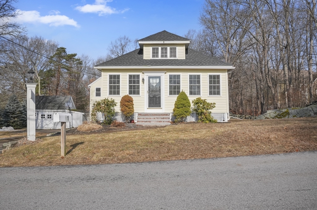
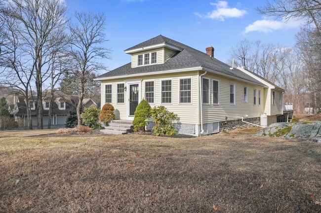
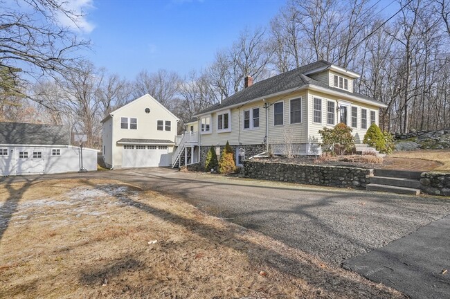
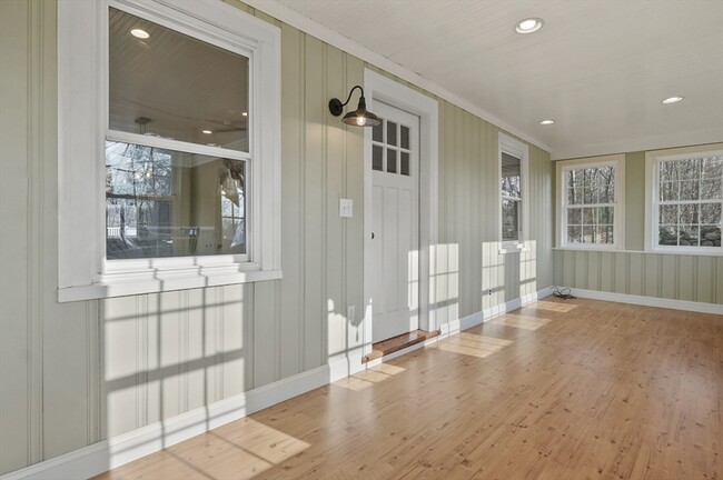
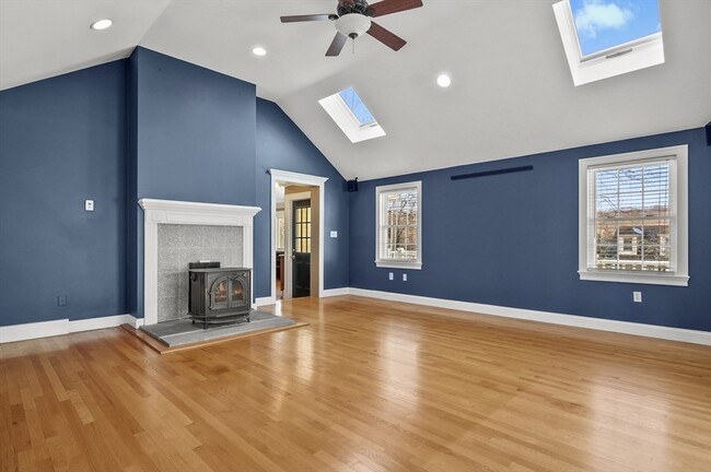
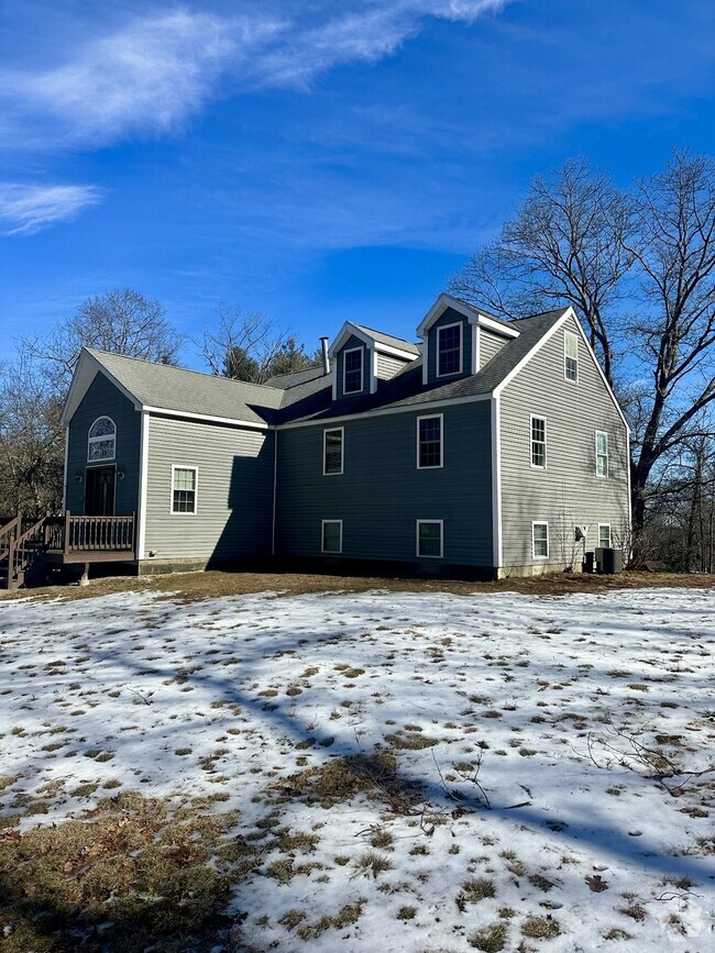
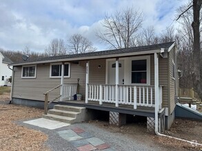
This completely renovated 3 to 4 bedroom Cape style home,nestled on a quiet winding road,is now available for rent. Enjoy the benefits of a fully renovated property Inside,discover a beautifully updated interior with high-end finishes and a dream kitchen. The home offers two bedrooms on main floor and one to two bedrooms downstairs in the bright,walk-out,above-grade lower level. A spacious 15x20 vaulted family room,complete with a wood stove for cozy evenings,provides ample living space. Step outside onto the expansive maintenance-free composite deck,overlooking a large,level backyard perfect for outdoor enjoyment. Plus,a massive two-car garage with plenty of storage. Don't miss the opportunity to rent this beautifully renovated home! Available for immediate occupancy ~ good rental history and credit references a must!
41 Mt Pleasant St is a house located in Worcester County and the 01581 ZIP Code. This area is served by the Westborough attendance zone.
Dishwasher
Refrigerator
Disposal
Range
Situated just moments east of Worcester is the Route 9 Corridor, a large neighborhood compiled of several communities including Shrewsbury, Westborough, Northborough, and Southborough. Not only is Worcester at residents’ fingertips, but Downtown Boston is less than 40 miles east. The Route 9 Corridor is a commuter’s dream, offering easy city access and entry onto Interstates 290, 495, and 90.
The suburb is dotted with ponds, reservoirs, brooks, and rivers, providing ample outdoor recreation. Renters craving a beach day can bask on the sunny shores of Lake Chauncy Beach. Route 9 Corridor’s Prospect Park allows locals to take their dog for a stroll while Assabet Park gives children ample space to play on the playground. Those looking for winter recreation won’t want to miss the powdery slopes of Ski Ward Ski Area. No matter the season, renters settling in this diverse community can choose from gorgeous apartments ranging in price and amenities.
Learn more about living in Route 9 Corridor| Colleges & Universities | Distance | ||
|---|---|---|---|
| Colleges & Universities | Distance | ||
| Drive: | 11 min | 4.2 mi | |
| Drive: | 19 min | 10.0 mi | |
| Drive: | 22 min | 11.5 mi | |
| Drive: | 23 min | 12.1 mi |
Transportation options available in Westborough include Riverside Station, located 23.3 miles from 41 Mt Pleasant St. 41 Mt Pleasant St is near Worcester Regional, located 16.8 miles or 33 minutes away, and General Edward Lawrence Logan International, located 36.4 miles or 55 minutes away.
| Transit / Subway | Distance | ||
|---|---|---|---|
| Transit / Subway | Distance | ||
|
|
Drive: | 37 min | 23.3 mi |
|
|
Drive: | 37 min | 23.6 mi |
|
|
Drive: | 38 min | 24.3 mi |
|
|
Drive: | 41 min | 25.9 mi |
|
|
Drive: | 41 min | 26.1 mi |
| Commuter Rail | Distance | ||
|---|---|---|---|
| Commuter Rail | Distance | ||
|
|
Drive: | 10 min | 3.5 mi |
|
|
Drive: | 11 min | 4.3 mi |
|
|
Drive: | 18 min | 8.3 mi |
|
|
Drive: | 24 min | 10.5 mi |
|
|
Drive: | 22 min | 11.5 mi |
| Airports | Distance | ||
|---|---|---|---|
| Airports | Distance | ||
|
Worcester Regional
|
Drive: | 33 min | 16.8 mi |
|
General Edward Lawrence Logan International
|
Drive: | 55 min | 36.4 mi |
Time and distance from 41 Mt Pleasant St.
| Shopping Centers | Distance | ||
|---|---|---|---|
| Shopping Centers | Distance | ||
| Drive: | 5 min | 1.7 mi | |
| Drive: | 8 min | 2.6 mi | |
| Drive: | 8 min | 2.7 mi |
| Parks and Recreation | Distance | ||
|---|---|---|---|
| Parks and Recreation | Distance | ||
|
Whitehall State Park
|
Drive: | 13 min | 4.0 mi |
|
Cedar Hill and Sawink Farm Reservation
|
Drive: | 12 min | 4.5 mi |
|
Upton State Forest
|
Drive: | 10 min | 4.5 mi |
|
Walkup And Robinson Memorial Reservation
|
Drive: | 11 min | 4.6 mi |
|
Ward Hill Ski Area
|
Drive: | 16 min | 6.7 mi |
| Hospitals | Distance | ||
|---|---|---|---|
| Hospitals | Distance | ||
| Drive: | 19 min | 9.6 mi | |
| Drive: | 19 min | 9.9 mi | |
| Drive: | 19 min | 10.5 mi |
| Military Bases | Distance | ||
|---|---|---|---|
| Military Bases | Distance | ||
| Drive: | 30 min | 16.3 mi |


What Are Walk Score®, Transit Score®, and Bike Score® Ratings?
Walk Score® measures the walkability of any address. Transit Score® measures access to public transit. Bike Score® measures the bikeability of any address.
What is a Sound Score Rating?
A Sound Score Rating aggregates noise caused by vehicle traffic, airplane traffic and local sources

41 Mt Pleasant St
Westborough, MA 01581